
FCCInfo.com
A Service of Cavell, Mertz & Associates, Inc.
(855) FCC-INFO
|
|
|
|  |
|
|||||||||||||||
|
|
WAGP Channel: 204C1 88.7 MHz Beaufort, South Carolina Service: FM - A full-service FM station or application. Facility ID: 12534 Fac. Service: FM Status: License Application Accepted: 03/17/2016 Application Granted: 03/23/2016 File Number: BLED-20160317ABU License Expires: 00/00/0000 Prefix Type: This is a license for a noncommercial educational FM station Application Type: License To Cover FCC Website Links: LMS Facility Details This Application CDBS Application Other WAGP Applications Other WAGP Applications in CDBS Including Superseded Applications Mailing Address Correspondence for WAGP Correspondence related to application BLED-20160317ABU Service Contour - Open Street Map or USGS Map (60 dBu) Service Contour - KML / Google Earth (60 dBu) Public Inspection Files Facility Type: NON-COMMERCIAL EDUC. FM Class: C1, A Zone II station; with 50kW-100kW ERP and a class contour distance 52km-72km Site Location: 32-21-27.8 N 80-55-10.6 W (NAD 83) Site Location: 32-21-27.1 N 80-55-11.2 W (Converted to NAD 27) Effective Radiated Power: 100 kW Transmitter Output Power: 17.63 kW Antenna Center HAAT: 101 m (331 ft.) Antenna Center AMSL: 105.4 m (346 ft.) Antenna Center HAG: 99 m (325 ft.) Calculated Site Elevation: 6.4 m. (21 ft.) Height Overall*: 111 m (364 ft.) (* As Filed In This Application, may differ from ASR Data, Below.) Directional Antenna Antenna Make/Model: Electronics Research Inc. MP-6E-DA Antenna ID: 119651 Polarization: | ||||||||||||||||||
| Antenna Data for Antenna Id: 119651 WAGP FM File: BLED-20160317ABU Electronics Research Inc. - MP-6E-DA Service: FM | 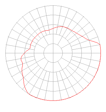 | ||||||||||||||||||
| Azimuth | Ratio | Azimuth | Ratio | Azimuth | Ratio | Azimuth | Ratio | ||||||||||||
| 0 | 0.514 | 10 | 0.554 | 20 | 0.587 | 30 | 0.606 | ||||||||||||
| 40 | 0.616 | 50 | 0.648 | 60 | 0.703 | 70 | 0.795 | ||||||||||||
| 80 | 1.000 | 90 | 1.000 | 100 | 1.000 | 110 | 1.000 | ||||||||||||
| 120 | 1.000 | 130 | 1.000 | 140 | 1.000 | 150 | 1.000 | ||||||||||||
| 160 | 1.000 | 170 | 1.000 | 180 | 1.000 | 190 | 1.000 | ||||||||||||
| 200 | 1.000 | 210 | 1.000 | 220 | 0.923 | 230 | 0.814 | ||||||||||||
| 240 | 0.752 | 250 | 0.680 | 260 | 0.680 | 270 | 0.597 | ||||||||||||
| 280 | 0.500 | 290 | 0.500 | 300 | 0.500 | 310 | 0.500 | ||||||||||||
| 320 | 0.500 | 330 | 0.500 | 340 | 0.495 | 350 | 0.487 | ||||||||||||
Structure Registration Number 1259038 Structure Type: TOWER Registered To: Community Broadcasting Corp. of Beaufort Inc. Structure Address: Hwy 462 1/2 Mile North Of Hwy 170 Okatie, SC County Name: Jasper County ASR Issued: 06/29/2007 Date Built: 01/29/2009 Site Elevation: 6.4 m (21 ft.) Structure Height: 111 m (364 ft.) Height Overall: 111 m (364 ft.) Overall Height AMSL: 117.4 m (385 ft.) FAA Determination: 06/27/2007 FAA Study #: 2007-ASO-2341-OE FAA Circular #: 70/7460-1K Paint & Light FAA Chapters: 4, 6, 12 Removed expiration date from determination. Scenario 1./jjs/case#635066 32-21-27.8 N 80-55-10.6 W (NAD 83) 32-21-27.1 N 80-55-11.2 W (Converted to NAD 27) |
P.o. Box 119 Beaufort, SC 29901 Not-for-Profit | Date: 03/17/2016 Application Certifier COMMUNITY BROADCASTING CORP. OF BEAUFORT, INC. P.o. Box 119 Beaufort, SC 29901 Applicant RICHARD FORSCHNER Community Broadcasting Corp. Of Beaufort, Inc. TIMOTHY L. WARNER, P.E. Timothy L. Warner, Inc. Post Office Box 8045 Asheville, NC 28814-8045 TECHNICAL CONSULTANT | |||||||||||||||||
| |||||||||||||||||||