
FCCInfo.com
A Service of Cavell, Mertz & Associates, Inc.
(855) FCC-INFO
|
|
|
|
|
||||||||||||||||
|
|
K211EI Channel: 211D 90.1 MHz Lamar, Colorado Service: FX - A translator or application for a translator. Facility ID: 92416 Fac. Service: FX Programming Delivery Method: Unspecified Status: License Application Accepted: 07/31/2012 Application Granted: 08/15/2012 File Number: BLFT-20120731ACX License Expires: 00/00/0000 Prefix Type: This is a license for a translator Application Type: License To Cover FCC Website Links: LMS Facility Details This Application CDBS Application Other K211EI Applications Other K211EI Applications in CDBS Including Superseded Applications Mailing Address Correspondence for K211EI Correspondence related to application BLFT-20120731ACX Service Contour - Open Street Map or USGS Map (60 dBu) Service Contour - KML / Google Earth (60 dBu) Class: D, A Noncommercial educational operating with no more than 10W Site Location: 38-02-14.0 N 102-35-52.7 W (NAD 83) Site Location: 38-02-14.0 N 102-35-51.0 W (Converted to NAD 27) Effective Radiated Power: 0 kW Horiz. ; 0.205 kW Vert. Transmitter Output Power: 0.183 kW Antenna Center HAAT: 70.9 m Horiz.; 0 m Vert. Antenna Center AMSL: 0 m Horiz.; 1217 m Vert. Antenna Center HAG: 0 m Horiz.; 64 m Vert. Site Elevation: 1153 m. (3783 ft.) Height Overall*: 81 m (266 ft.) (* As Filed In This Application, may differ from ASR Data, Below.) Directional Antenna Antenna Make/Model: None Antenna ID: 31326 Polarization:
| ||||||||||||||||||
| Antenna Data for Antenna Id: 31326 K211EI FX File: BLFT-20120731ACX None - Service: FX | 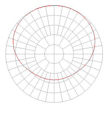 | ||||||||||||||||||
| Azimuth | Ratio | Azimuth | Ratio | Azimuth | Ratio | Azimuth | Ratio | ||||||||||||
| 0 | 1.000 | 10 | 0.999 | 20 | 0.995 | 30 | 0.987 | ||||||||||||
| 40 | 0.975 | 50 | 0.956 | 60 | 0.929 | 70 | 0.892 | ||||||||||||
| 80 | 0.845 | 90 | 0.792 | 100 | 0.735 | 110 | 0.679 | ||||||||||||
| 120 | 0.630 | 130 | 0.592 | 140 | 0.566 | 150 | 0.549 | ||||||||||||
| 160 | 0.540 | 170 | 0.535 | 180 | 0.534 | 190 | 0.535 | ||||||||||||
| 200 | 0.540 | 210 | 0.549 | 220 | 0.566 | 230 | 0.592 | ||||||||||||
| 240 | 0.630 | 250 | 0.679 | 260 | 0.735 | 270 | 0.792 | ||||||||||||
| 280 | 0.845 | 290 | 0.892 | 300 | 0.929 | 310 | 0.956 | ||||||||||||
| 320 | 0.975 | 330 | 0.987 | 340 | 0.995 | 350 | 0.999 | ||||||||||||
Structure Registration Number 1027634 Structure Type: TOWER Registered To: Big Towers, LLC Structure Address: 2.5 Mi S On Hwy 287 1 Mi E Lamar, CO County Name: Prowers County ASR Issued: 06/01/2012 Date Built: 05/30/2013 Site Elevation: 1153.3 m (3784 ft.) Structure Height: 73.2 m (240 ft.) Height Overall: 80.7 m (265 ft.) Overall Height AMSL: 1234 m (4049 ft.) FAA Determination: 10/11/1994 FAA Study #: 94-ANM-0809-OE FAA Circular #: 70/7460-1H Paint & Light FAA Chapters: 3, 4, 5, 13 38-02-14.0 N 102-35-53.0 W (NAD 83) 38-02-14.0 N 102-35-51.3 W (Converted to NAD 27) |
4002 N. 3300 E. Twin Falls, ID 83301 Phone: 208-734-6633 Not-for-Profit | Date: 07/31/2012 Application Certifier CALVARY CHAPEL OF TWIN FALLS, INC. Po Box 391 Twin Falls, ID 83303 Applicant LOIS MILLS Po Box 391 Twin Falls, ID 83303 APPLICATION TECHNICIAN CARY TEPPER Booth, Freret, Imlay And Tepper, Pc 7900 Wisconsin Ave, Suite 304 Bethesda, MD 20814-3628 | |||||||||||||||||