
FCCInfo.com
A Service of Cavell, Mertz & Associates, Inc.
(855) FCC-INFO
|
|
W294AR from 05/01/2007 W294AR from 05/14/2004 |
|
|
||||||||||||||||
|
|
W294AR Channel: 294D 106.7 MHz Auburn, Alabama Service: FX - A translator or application for a translator. Facility ID: 141199 Fac. Service: FX Programming Delivery Method: Unspecified Status: Construction Permit Application Accepted: 07/17/2017 Application Pending: 07/18/2017 File Number: BMPFT-20170717ACX W294AR CP Expires: 00/00/0000 Prefix Type: This is a modification of construction permit for a translator Application Type: Minor Amendment FCC Website Links: LMS Facility Details This Application CDBS Application Other W294AR Applications Other W294AR Applications in CDBS Including Superseded Applications Mailing Address Correspondence for W294AR Correspondence related to application BMPFT-20170717ACX Service Contour - Open Street Map or USGS Map (60 dBu) Service Contour - KML / Google Earth (60 dBu) Class: D, A Noncommercial educational operating with no more than 10W Site Location: 32-40-03.5 N 85-33-00.8 W (NAD 83) Site Location: 32-40-03.0 N 85-33-01.0 W (Converted to NAD 27) Effective Radiated Power: 0.25 kW Antenna Center HAAT: 0 m Antenna Center AMSL: 366 m (1201 ft.) Antenna Center HAG: 143 m (469 ft.) Site Elevation: 223 m. (732 ft.) Height Overall*: 152 m (499 ft.) (* As Filed In This Application, may differ from ASR Data, Below.) Directional Antenna Antenna Make/Model: None Antenna ID: 134543 Polarization:
| ||||||||||||||||||
| Antenna Data for Antenna Id: 134543 W294AR FX File: BMPFT-20170717ACX None - Service: FX Pattern and Field Values Include a 130° Clockwise Rotation | 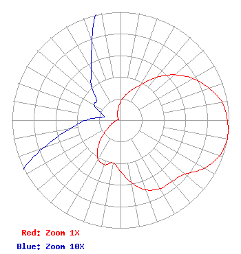 | ||||||||||||||||||
| Azimuth | Ratio | Azimuth | Ratio | Azimuth | Ratio | Azimuth | Ratio | ||||||||||||
| 0 | 0.169 | 10 | 0.228 | 20 | 0.294 | 30 | 0.378 | ||||||||||||
| 40 | 0.519 | 50 | 0.653 | 60 | 0.771 | 70 | 0.867 | ||||||||||||
| 80 | 0.951 | 90 | 0.986 | 100 | 1.000 | 110 | 0.970 | ||||||||||||
| 120 | 0.889 | 130 | 0.778 | 140 | 0.739 | 150 | 0.731 | ||||||||||||
| 160 | 0.686 | 170 | 0.589 | 180 | 0.474 | 190 | 0.401 | ||||||||||||
| 200 | 0.438 | 210 | 0.414 | 220 | 0.322 | 230 | 0.205 | ||||||||||||
| 240 | 0.120 | 250 | 0.076 | 260 | 0.048 | 270 | 0.032 | ||||||||||||
| 280 | 0.016 | 290 | 0.019 | 300 | 0.028 | 310 | 0.029 | ||||||||||||
| 320 | 0.042 | 330 | 0.054 | 340 | 0.077 | 350 | 0.116 | ||||||||||||
Structure Registration Number 1307550 Structure Type: GTOWER Registered To: Hubbard Properties LLC Structure Address: Farmville Road Auburn, AL County Name: Lee County ASR Issued: 11/06/2019 Date Built: 11/04/2019 Site Elevation: 223.1 m (732 ft.) Structure Height: 151 m (495 ft.) Height Overall: 152.1 m (499 ft.) Overall Height AMSL: 375.2 m (1231 ft.) FAA Determination: 07/17/2017 FAA Study #: 2017-ASO-12172-OE FAA Circular #: 70/7460-1L Paint & Light FAA Chapters: 3, 4, 5, 12 Removed expiration date from determination. Scenario 1./jjs/case#635066 32-40-04.0 N 85-33-00.8 W (NAD 83) 32-40-03.5 N 85-33-01.0 W (Converted to NAD 27) |
P.o. Box 950 Auburn, AL 36831-0950 Phone: 334-826-2929 | Date: 07/17/2017 Application Certifier AUBURN NETWORK, INC. P.o. Box 950 Auburn, AL 36831-0950 Applicant LEE REYNOLDS P. O. Box 383174 Birmingham, AL 35238 CONSULTING ENGINEER MARK LIPP Fletcher Heald & Hildreth Plc 1300 N. 17th Street Arlington, VA 22209 | |||||||||||||||||