
FCCInfo.com
A Service of Cavell, Mertz & Associates, Inc.
(855) FCC-INFO
|
|
K283CN from 09/28/2009 K283CN from 09/08/2004 |
|
|
||||||||||||||||
|
|
K283CN Channel: 283D 104.5 MHz Fort Collins, Colorado Service: FX - A translator or application for a translator. Facility ID: 149712 Fac. Service: FX Programming Delivery Method: Unspecified Status: License Application Accepted: 06/21/2017 Application Granted: 07/03/2017 File Number: BLFT-20170621AAE License Expires: 00/00/0000 Prefix Type: This is a license for a translator Application Type: License To Cover FCC Website Links: LMS Facility Details This Application CDBS Application Other K283CN Applications Other K283CN Applications in CDBS Including Superseded Applications Mailing Address Correspondence for K283CN Correspondence related to application BLFT-20170621AAE Service Contour - Open Street Map or USGS Map (60 dBu) Service Contour - KML / Google Earth (60 dBu) Class: D, A Noncommercial educational operating with no more than 10W Site Location: 40-32-46.9 N 105-11-54.9 W (NAD 83) Site Location: 40-32-47.0 N 105-11-53.0 W (Converted to NAD 27) Effective Radiated Power: 0.08 kW Transmitter Output Power: 0.032 kW Antenna Center HAAT: 0 m Antenna Center AMSL: 2185 m (7169 ft.) Antenna Center HAG: 12 m (39 ft.) Site Elevation: 2173 m. (7129 ft.) Height Overall*: 30 m (98 ft.) (* As Filed In This Application, may differ from ASR Data, Below.) Directional Antenna Antenna Make/Model: None Antenna ID: 127243 Polarization:
| ||||||||||||||||||
| Antenna Data for Antenna Id: 127243 K283CN FX File: BLFT-20170621AAE None - Service: FX Pattern and Field Values Include a 63° Clockwise Rotation | 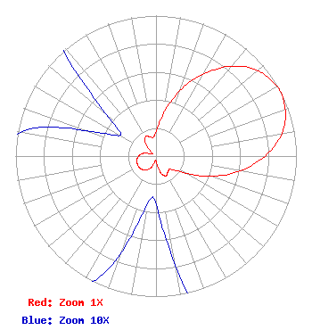 | ||||||||||||||||||
| Azimuth | Ratio | Azimuth | Ratio | Azimuth | Ratio | Azimuth | Ratio | ||||||||||||
| 3 | 0.203 | 13 | 0.363 | 23 | 0.553 | 33 | 0.727 | ||||||||||||
| 43 | 0.871 | 48 | 0.928 | 53 | 0.966 | 58 | 0.986 | ||||||||||||
| 63 | 1.000 | 68 | 0.986 | 73 | 0.966 | 78 | 0.928 | ||||||||||||
| 83 | 0.871 | 93 | 0.727 | 103 | 0.553 | 113 | 0.363 | ||||||||||||
| 123 | 0.203 | 133 | 0.138 | 143 | 0.141 | 153 | 0.157 | ||||||||||||
| 163 | 0.130 | 173 | 0.060 | 183 | 0.030 | 193 | 0.042 | ||||||||||||
| 203 | 0.088 | 213 | 0.117 | 223 | 0.134 | 233 | 0.143 | ||||||||||||
| 243 | 0.145 | 253 | 0.143 | 263 | 0.134 | 273 | 0.117 | ||||||||||||
| 283 | 0.088 | 293 | 0.042 | 303 | 0.030 | 313 | 0.060 | ||||||||||||
| 323 | 0.130 | 333 | 0.157 | 343 | 0.141 | 353 | 0.138 | ||||||||||||
Structure Registration Number 1271533 Structure Type: Registered To: RF Towers, LLC Structure Address: Soderburg Communications Site Fort Collins, CO County Name: Larimer County ASR Issued: 02/10/2024 Date Built: 11/07/2010 Site Elevation: 2172.9 m (7129 ft.) Structure Height: 27.7 m (91 ft.) Height Overall: 29.9 m (98 ft.) Overall Height AMSL: 2202.8 m (7227 ft.) FAA Determination: 07/02/2009 FAA Study #: 2009-ANM-988-OE Paint & Light FAA Chapters: NONE Removed expiration date from determination. Scenario 1./jjs/case#635066 40-32-46.9 N 105-11-54.8 W (NAD 83) 40-32-47.0 N 105-11-52.9 W (Converted to NAD 27) |
288 South River Road Bedford, NH 03110 Phone: 603-668-6400 | Date: 06/21/2017 Application Certifier BRAHMIN BROADCASTING CORPORATION 288 South River Road Bedford, NH 03110 Applicant AARON ISHMAEL Po Box 123 Windsor, CO 80550 TECHNICAL CONSULTANT LISA BURGESS Brahmin Broadcasting 288 South River Road Bedford, NH 03110 | |||||||||||||||||