
FCCInfo.com
A Service of Cavell, Mertz & Associates, Inc.
(855) FCC-INFO
|
|
WSTV from 12/17/2007 WSTV from 03/15/2005 WSTV from 02/21/2001 WSTV from 12/15/1993 WSTV from 09/01/1992 WSTV from 06/04/1992 |
|
|
||||||||||||||||
|
|
WSTV Channel: 285C2 104.9 MHz Roanoke, Virginia Service: FM - A full-service FM station or application. Facility ID: 64082 Fac. Service: FM Status: License 73.215 Station Application Accepted: 07/23/2004 Application Granted: 08/26/2004 File Number: BLH-20040723ADP License Expires: 00/00/0000 Prefix Type: This is a license for a commercial FM station Application Type: License To Cover FCC Website Links: LMS Facility Details This Application CDBS Application Other WSTV Applications Other WSTV Applications in CDBS Including Superseded Applications Mailing Address Correspondence for WSTV Correspondence related to application BLH-20040723ADP Service Contour - Open Street Map or USGS Map (60 dBu) Service Contour - KML / Google Earth (60 dBu) Public Inspection Files Facility Type: FM STATION Class: C2, A Zone II station; with 25kW-50kW ERP and a class contour distance 39km-52km Site Location: 37-22-23.5 N 79-55-39.1 W (NAD 83) Site Location: 37-22-23.0 N 79-55-40.0 W (Converted to NAD 27) Effective Radiated Power: 14.5 kW Transmitter Output Power: 8.2 kW Antenna Center HAAT: 282 m (925 ft.) Antenna Center AMSL: 699 m (2293 ft.) Antenna Center HAG: 24 m (79 ft.) Calculated Site Elevation: 675 m. (2215 ft.) Height Overall*: 30 m (98 ft.) (* As Filed In This Application, may differ from ASR Data, Below.) Directional Antenna Antenna Make/Model: Electronics Research Inc. MP-4E-DA-HW Antenna ID: 64872 Polarization:
| ||||||||||||||||||
| Antenna Data for Antenna Id: 64872 WSTV FM File: BLH-20040723ADP Electronics Research Inc. - MP-4E-DA-HW Service: FM | 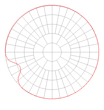 | ||||||||||||||||||
| Azimuth | Ratio | Azimuth | Ratio | Azimuth | Ratio | Azimuth | Ratio | ||||||||||||
| 0 | 1.000 | 10 | 1.000 | 20 | 1.000 | 30 | 1.000 | ||||||||||||
| 40 | 1.000 | 50 | 1.000 | 60 | 1.000 | 70 | 1.000 | ||||||||||||
| 80 | 1.000 | 90 | 1.000 | 100 | 1.000 | 110 | 1.000 | ||||||||||||
| 120 | 1.000 | 130 | 1.000 | 140 | 1.000 | 150 | 1.000 | ||||||||||||
| 160 | 1.000 | 170 | 1.000 | 180 | 1.000 | 190 | 1.000 | ||||||||||||
| 200 | 1.000 | 210 | 1.000 | 220 | 1.000 | 230 | 0.944 | ||||||||||||
| 240 | 0.775 | 250 | 0.775 | 260 | 0.944 | 270 | 1.000 | ||||||||||||
| 280 | 1.000 | 290 | 1.000 | 300 | 1.000 | 310 | 1.000 | ||||||||||||
| 320 | 1.000 | 330 | 1.000 | 340 | 1.000 | 350 | 1.000 | ||||||||||||
Structure Registration Number 1240762 [ASR Heights Differ from WSTV Application] Structure Type: TOWER Registered To: Vertical Bridge Towers, IV LLC Structure Address: Southernmost Point On Plateau Atop Tinker Mountain Cloverdale, VA County Name: Botetourt County ASR Issued: 10/11/2023 Date Built: 07/15/2004 Site Elevation: 674.5 m (2213 ft.) Structure Height: 30.2 m (99 ft.) Height Overall: 30.2 m (99 ft.) Overall Height AMSL: 704.7 m (2312 ft.) FAA Determination: 10/03/2003 FAA Study #: 2003-AEA-2802-OE Paint & Light FAA Chapters: NONE PRIOR STUDY 2003-AEA-652-OE 37-22-23.3 N 79-55-39.1 W (NAD 83) 37-22-22.8 N 79-55-40.0 W (Converted to NAD 27) |
7136 S. Yale Avenue Suite 501 Tulsa, OK 74136 Phone: 918-664-4581 | Date: 07/23/2004 Application Certifier CAPSTAR TX LIMITED PARTNERSHIP 2625 S. Memorial Drive Suite A Tulsa, OK 74129 Applicant BRAD A. DAVIS 2625 S. Memorial Drive Suite A Tulsa, OK 74129 ENGINEER MARISSA G. REPP Hogan & Hartson Llp | |||||||||||||||||
| |||||||||||||||||||