
FCCInfo.com
A Service of Cavell, Mertz & Associates, Inc.
(855) FCC-INFO
|
|
|
|
|
||||||||||||||||
|
|
K297AJ Channel: 297D 107.3 MHz Coburg, Oregon Service: FX - A translator or application for a translator. Facility ID: 156460 Fac. Service: FX Programming Delivery Method: Unspecified Status: License Application Accepted: 06/21/2017 Application Granted: 07/03/2017 File Number: BLFT-20170621AAO License Expires: 00/00/0000 Prefix Type: This is a license for a translator Application Type: License To Cover FCC Website Links: LMS Facility Details This Application CDBS Application Other K297AJ Applications Other K297AJ Applications in CDBS Including Superseded Applications Mailing Address Correspondence for K297AJ Correspondence related to application BLFT-20170621AAO Service Contour - Open Street Map or USGS Map (60 dBu) Service Contour - KML / Google Earth (60 dBu) Class: D, A Noncommercial educational operating with no more than 10W Site Location: 44-11-45.4 N 122-59-14.3 W (NAD 83) Site Location: 44-11-46.0 N 122-59-10.0 W (Converted to NAD 27) Effective Radiated Power: 0.135 kW Transmitter Output Power: 0.153 kW Antenna Center HAAT: 0 m Antenna Center AMSL: 1011 m (3317 ft.) Antenna Center HAG: 55 m (180 ft.) Site Elevation: 956 m. (3136 ft.) Height Overall*: 59 m (194 ft.) (* As Filed In This Application, may differ from ASR Data, Below.) Directional Antenna Antenna Make/Model: None Antenna ID: 127322 Polarization:
| ||||||||||||||||||
| Antenna Data for Antenna Id: 127322 K297AJ FX File: BLFT-20170621AAO None - Service: FX | 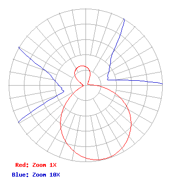 | ||||||||||||||||||
| Azimuth | Ratio | Azimuth | Ratio | Azimuth | Ratio | Azimuth | Ratio | ||||||||||||
| 0 | 0.242 | 10 | 0.218 | 20 | 0.172 | 30 | 0.104 | ||||||||||||
| 40 | 0.056 | 50 | 0.042 | 60 | 0.035 | 70 | 0.031 | ||||||||||||
| 80 | 0.038 | 90 | 0.116 | 100 | 0.288 | 110 | 0.479 | ||||||||||||
| 120 | 0.642 | 130 | 0.772 | 140 | 0.875 | 150 | 0.949 | ||||||||||||
| 160 | 0.989 | 170 | 0.989 | 180 | 0.949 | 190 | 0.875 | ||||||||||||
| 200 | 0.772 | 210 | 0.642 | 220 | 0.479 | 230 | 0.288 | ||||||||||||
| 240 | 0.116 | 250 | 0.038 | 260 | 0.031 | 270 | 0.035 | ||||||||||||
| 280 | 0.042 | 290 | 0.056 | 300 | 0.104 | 310 | 0.172 | ||||||||||||
| 320 | 0.218 | 330 | 0.242 | 340 | 0.255 | 350 | 0.255 | ||||||||||||
Structure Registration Number 1034283 Structure Type: LTOWER Registered To: American Towers LLC Structure Address: Buck Mtn., 3.5 Mi. N Of Mcgowan Creek Rd. (buck Mtn #8214) Springfield, OR County Name: Lane County ASR Issued: 01/15/2013 Date Built: 01/16/2002 Site Elevation: 955.8 m (3136 ft.) Structure Height: 56.7 m (186 ft.) Height Overall: 59.4 m (195 ft.) Overall Height AMSL: 1015.2 m (3331 ft.) FAA Determination: 12/03/2012 FAA Study #: 2012-ANM-2995-OE Paint & Light FAA Chapters: NONE PRIOR STUDY 2011-ANM-2900-OE 44-11-45.9 N 122-59-14.4 W (NAD 83) 44-11-46.5 N 122-59-10.1 W (Converted to NAD 27) |
5700 West Oaks Blvd. Rocklin, CA 95765 Phone: 916-251-1600 | Date: 06/21/2017 Application Certifier EDUCATIONAL MEDIA FOUNDATION 5700 West Oaks Blvd Rocklin, CA 95765 Applicant STEPHEN WILDE 5700 West Oaks Blvd Rocklin, CA 95765 RF DESIGN ENGINEER MARY O'CONNOR Educational Media Foundation 1800 M Street, N.w. Suite 800n Washington, DC 20036 | |||||||||||||||||