
FCCInfo.com
A Service of Cavell, Mertz & Associates, Inc.
(855) FCC-INFO
|
|
WXCY-FM from 03/01/1989 |
|  |
|
|||||||||||||||
|
|
WXCY-FM Channel: 279B 103.7 MHz Havre De Grace, Maryland Service: FM - A full-service FM station or application. Facility ID: 53488 Fac. Service: FM Status: License Application Accepted: 10/15/2002 Application Granted: 10/23/2002 File Number: BLH-20021015ABT License Expires: 00/00/0000 Prefix Type: This is a license for a commercial FM station Application Type: License To Cover FCC Website Links: LMS Facility Details This Application CDBS Application Other WXCY-FM Applications Other WXCY-FM Applications in CDBS Including Superseded Applications Mailing Address Correspondence for WXCY-FM Correspondence related to application BLH-20021015ABT Service Contour - Open Street Map or USGS Map (54 dBu) Service Contour - KML / Google Earth (54 dBu) Public Inspection Files History Cards for WXCY-FM Facility Type: FM STATION Class: B, A Zone I or I-A station; with 25kW-50kW ERP and a class contour distance 39km-52km Site Location: 39-33-52.4 N 76-06-05.8 W (NAD 83) Site Location: 39-33-52.0 N 76-06-07.0 W (Converted to NAD 27) Effective Radiated Power: 37 kW Transmitter Output Power: 17.35 kW Antenna Center HAAT: 168 m (551 ft.) Antenna Center AMSL: 217 m (712 ft.) Antenna Center HAG: 149 m (489 ft.) Site Elevation: 68 m. (223 ft.) Height Overall*: 160 m (525 ft.) (* As Filed In This Application, may differ from ASR Data, Below.) Directional Antenna Antenna Make/Model: Electronics Research Inc. MP-4E-DA-HW Antenna ID: 34444 Polarization: | ||||||||||||||||||
| Antenna Data for Antenna Id: 34444 WXCY-FM FM File: BLH-20021015ABT Electronics Research Inc. - MP-4E-DA-HW Service: FM | 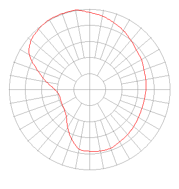 | ||||||||||||||||||
| Azimuth | Ratio | Azimuth | Ratio | Azimuth | Ratio | Azimuth | Ratio | ||||||||||||
| 0 | 0.957 | 10 | 0.924 | 20 | 0.883 | 30 | 0.843 | ||||||||||||
| 40 | 0.796 | 50 | 0.760 | 60 | 0.743 | 70 | 0.718 | ||||||||||||
| 80 | 0.709 | 90 | 0.701 | 100 | 0.693 | 110 | 0.693 | ||||||||||||
| 120 | 0.701 | 130 | 0.718 | 140 | 0.734 | 150 | 0.751 | ||||||||||||
| 160 | 0.778 | 170 | 0.778 | 180 | 0.769 | 190 | 0.751 | ||||||||||||
| 200 | 0.654 | 210 | 0.544 | 220 | 0.448 | 230 | 0.404 | ||||||||||||
| 240 | 0.390 | 250 | 0.381 | 260 | 0.385 | 270 | 0.432 | ||||||||||||
| 280 | 0.544 | 290 | 0.685 | 300 | 0.863 | 310 | 0.946 | ||||||||||||
| 320 | 0.979 | 330 | 1.000 | 340 | 1.000 | 350 | 1.000 | ||||||||||||
Structure Registration Number 1035692 [ASR Heights Differ from WXCY-FM Application] Structure Type: GTOWER Registered To: Global Tower, LLC. through American Towers, LLC Structure Address: 100 Lagaret Ln (371878 / Havre De Grace) Havre De Grace, MD County Name: Harford County ASR Issued: 01/22/2016 Date Built: 01/03/1992 Site Elevation: 68 m (223 ft.) Structure Height: 153.9 m (505 ft.) Height Overall: 155.8 m (511 ft.) Overall Height AMSL: 223.8 m (734 ft.) FAA Determination: 01/14/2016 FAA Study #: 2016-AEA-270-OE FAA Circular #: 70/7460-1L Paint & Light FAA Chapters: 4, 8, 12 PRIOR STUDY 2015-AEA-3899-OE 39-33-52.1 N 76-06-05.7 W (NAD 83) 39-33-51.7 N 76-06-06.9 W (Converted to NAD 27) |
274 Lakemont Park Blvd Altoona, PA 16602 Phone: 412-221-1629 Limited Liability Company | Date: 10/15/2002 Application Certifier DELMARVA BROADCASTING COMPANY 2727 Shipley Road Wilmington, DE 19803 Applicant JEFF TWILLEY 2727 Shipley Road Wilmington, DE 19803 CHIEF ENGINEER BRAD C. DEUTSCH Hogan & Hartson L.l.p. | |||||||||||||||||
| |||||||||||||||||||