
FCCInfo.com
A Service of Cavell, Mertz & Associates, Inc.
(855) FCC-INFO
|
|
|
|
|
||||||||||||||||
|
|
WJES Channel: 265A 100.9 MHz Maysville, Georgia Service: FM - A full-service FM station or application. Facility ID: 198772 Fac. Service: FM Status: License 73.215 Station Application Accepted: 11/17/2016 Application Granted: 12/29/2016 File Number: BLH-20161117ABU License Expires: 00/00/0000 Prefix Type: This is a license for a commercial FM station Application Type: License To Cover FCC Website Links: LMS Facility Details This Application CDBS Application Other WJES Applications Other WJES Applications in CDBS Including Superseded Applications Mailing Address Correspondence for WJES Correspondence related to application BLH-20161117ABU Service Contour - Open Street Map or USGS Map (60 dBu) Service Contour - KML / Google Earth (60 dBu) Public Inspection Files Facility Type: FM STATION Class: A, A Zone I; I-A; or II station; with 0.1kW-6kW ERP and a class contour distance <=28km Site Location: 34-20-09.0 N 83-39-06.0 W (NAD 83) Site Location: 34-20-08.6 N 83-39-06.4 W (Converted to NAD 27) Effective Radiated Power: 6 kW Transmitter Output Power: 3.2 kW Antenna Center HAAT: 99 m (325 ft.) Antenna Center AMSL: 398.2 m (1306 ft.) Antenna Center HAG: 68.1 m (223 ft.) Calculated Site Elevation: 330.1 m. (1083 ft.) Height Overall*: 98.4 m (323 ft.) (* As Filed In This Application, may differ from ASR Data, Below.) Directional Antenna Antenna Make/Model: Propagation System Inc FMR-3E-DA, three sections Antenna ID: 122178 Polarization: | ||||||||||||||||||
| Antenna Data for Antenna Id: 122178 WJES FM File: BLH-20161117ABU Propagation System Inc - FMR-3E-DA, three sections Service: FM | 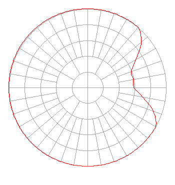 | ||||||||||||||||||
| Azimuth | Ratio | Azimuth | Ratio | Azimuth | Ratio | Azimuth | Ratio | ||||||||||||
| 0 | 1.000 | 10 | 1.000 | 20 | 1.000 | 30 | 1.000 | ||||||||||||
| 40 | 1.000 | 50 | 0.890 | 60 | 0.710 | 70 | 0.590 | ||||||||||||
| 80 | 0.590 | 90 | 0.590 | 100 | 0.710 | 110 | 0.890 | ||||||||||||
| 120 | 1.000 | 130 | 1.000 | 140 | 1.000 | 150 | 1.000 | ||||||||||||
| 160 | 1.000 | 170 | 1.000 | 180 | 1.000 | 190 | 1.000 | ||||||||||||
| 200 | 1.000 | 210 | 1.000 | 220 | 1.000 | 230 | 1.000 | ||||||||||||
| 240 | 1.000 | 250 | 1.000 | 260 | 1.000 | 270 | 1.000 | ||||||||||||
| 280 | 1.000 | 290 | 1.000 | 300 | 1.000 | 310 | 1.000 | ||||||||||||
| 320 | 1.000 | 330 | 1.000 | 340 | 1.000 | 350 | 1.000 | ||||||||||||
Structure Registration Number 1018671 Structure Type: GTOWER Registered To: MidAmerica Towers, Inc Structure Address: 2 Mi Nnw Gillsville, GA County Name: Hall County ASR Issued: 08/16/2013 Date Built: 08/19/2013 Site Elevation: 330.1 m (1083 ft.) Structure Height: 91.4 m (300 ft.) Height Overall: 98.4 m (323 ft.) Overall Height AMSL: 428.5 m (1406 ft.) FAA Determination: 06/10/2011 FAA Study #: 2011-ASO-3021-OE FAA Circular #: 70/7460-1K Paint & Light FAA Chapters: 3, 4, 5, 12 PRIOR STUDY 1989-ASO-1821-OE 34-20-09.0 N 83-39-06.0 W (NAD 83) 34-20-08.6 N 83-39-06.4 W (Converted to NAD 27) |
1625 Saint Julian St. Suwanee, GA 30024 Individual | Date: 11/17/2016 Application Certifier NELSON RODRIGUEZ 1625 Saint Julian Street Suwanne, GA 30024 Applicant CLIFTON G MOOR Bromo Communications, Inc. 3600 Dallas Highway, Suite 230 - Pmb 164 Marietta, GA 30064 TECHNICAL CONSULTANT DONALD E. MARTIN Donald E. Martin, P.c. | |||||||||||||||||