
FCCInfo.com
A Service of Cavell, Mertz & Associates, Inc.
(855) FCC-INFO
|
|
K248CU from 04/24/2014 K248CU from 10/29/2013 |
|
|
||||||||||||||||
|
|
K248CU Channel: 248D 97.5 MHz Austin, Texas Service: FX - A translator or application for a translator. Facility ID: 143307 Fac. Service: FX Programming Delivery Method: Unspecified Status: License Application Accepted: 12/15/2015 Application Granted: 01/11/2016 File Number: BLFT-20151215ACK License Expires: 00/00/0000 Prefix Type: This is a license for a translator Application Type: License To Cover FCC Website Links: LMS Facility Details This Application CDBS Application Other K248CU Applications Other K248CU Applications in CDBS Including Superseded Applications Mailing Address Correspondence for K248CU Correspondence related to application BLFT-20151215ACK Service Contour - Open Street Map or USGS Map (60 dBu) Service Contour - KML / Google Earth (60 dBu) Class: D, A Noncommercial educational operating with no more than 10W Site Location: 30-19-23.8 N 97-47-59.5 W (NAD 83) Site Location: 30-19-23.1 N 97-47-58.5 W (Converted to NAD 27) Effective Radiated Power: 0.25 kW Transmitter Output Power: 0.414 kW Antenna Center HAAT: 0 m Antenna Center AMSL: 516 m (1693 ft.) Antenna Center HAG: 267 m (876 ft.) Site Elevation: 249 m. (817 ft.) Height Overall*: 375 m (1230 ft.) (* As Filed In This Application, may differ from ASR Data, Below.) Directional Antenna Antenna Make/Model: None Antenna ID: 122084 Polarization:
| ||||||||||||||||||
| Antenna Data for Antenna Id: 122084 K248CU FX File: BLFT-20151215ACK None - Service: FX | 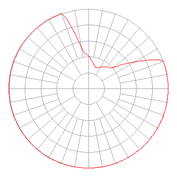 | ||||||||||||||||||
| Azimuth | Ratio | Azimuth | Ratio | Azimuth | Ratio | Azimuth | Ratio | ||||||||||||
| 0 | 0.407 | 10 | 0.325 | 20 | 0.280 | 30 | 0.310 | ||||||||||||
| 40 | 0.353 | 50 | 0.415 | 60 | 0.668 | 70 | 1.000 | ||||||||||||
| 80 | 1.000 | 90 | 1.000 | 100 | 1.000 | 110 | 1.000 | ||||||||||||
| 120 | 1.000 | 130 | 1.000 | 140 | 1.000 | 150 | 1.000 | ||||||||||||
| 160 | 1.000 | 170 | 1.000 | 180 | 1.000 | 190 | 1.000 | ||||||||||||
| 200 | 1.000 | 210 | 1.000 | 220 | 1.000 | 230 | 1.000 | ||||||||||||
| 240 | 1.000 | 250 | 1.000 | 260 | 1.000 | 270 | 1.000 | ||||||||||||
| 280 | 1.000 | 290 | 1.000 | 300 | 1.000 | 310 | 1.000 | ||||||||||||
| 320 | 1.000 | 330 | 1.000 | 340 | 1.000 | 350 | 0.525 | ||||||||||||
Structure Registration Number 1013180 Structure Type: GTOWER Registered To: American Towers LLC Structure Address: 5319 Buckman Mountain Road (007000) Austin, TX County Name: Travis County ASR Issued: 06/17/2016 Date Built: 10/08/1997 Site Elevation: 249.3 m (818 ft.) Structure Height: 351.1 m (1152 ft.) Height Overall: 374.6 m (1229 ft.) Overall Height AMSL: 623.9 m (2047 ft.) FAA Determination: 06/04/2013 FAA Study #: 2013-ASW-3758-OE FAA Circular #: 70/7460-1K Paint & Light FAA Chapters: 3, 4, 5, 12 PRIOR STUDY 2013-ASW-2050-OE 30-19-23.8 N 97-47-59.5 W (NAD 83) 30-19-23.1 N 97-47-58.5 W (Converted to NAD 27) |
24180 Forest Drive Forest Lake, IL 60047 Phone: 847-540-5410 | Date: 12/15/2015 Application Certifier AUSLATOR LLC 24180 Forest Drive Forest Lake, IL 60047 Applicant DONALD LYNCH 111 Sam Houston Drive Kerrville, TX 78028 TECHNICAL CONSULTANT KATHLEEN VICTORY Fletcher Heald & Hildreth, Plc 1300 N. 17th Street 11th Floor Arlington, VA 22209 | |||||||||||||||||