
FCCInfo.com
A Service of Cavell, Mertz & Associates, Inc.
(855) FCC-INFO
|
|
W299CH from 04/24/2013 |
|
|
||||||||||||||||
|
|
W299CH Channel: 299D 107.7 MHz Morganfield, Kentucky Service: FX - A translator or application for a translator. Facility ID: 145129 Fac. Service: FX Programming Delivery Method: Unspecified Status: License Application Accepted: 04/04/2016 Application Granted: 04/18/2016 File Number: BLFT-20160404ACQ License Expires: 00/00/0000 Prefix Type: This is a license for a translator Application Type: License To Cover FCC Website Links: LMS Facility Details This Application CDBS Application Other W299CH Applications Other W299CH Applications in CDBS Including Superseded Applications Mailing Address Correspondence for W299CH Correspondence related to application BLFT-20160404ACQ Service Contour - Open Street Map or USGS Map (60 dBu) Service Contour - KML / Google Earth (60 dBu) Class: D, A Noncommercial educational operating with no more than 10W Site Location: 37-40-04.2 N 87-55-46.1 W (NAD 83) Site Location: 37-40-04.0 N 87-55-46.0 W (Converted to NAD 27) Effective Radiated Power: 0.25 kW Transmitter Output Power: 0.81 kW Antenna Center HAAT: 0 m Antenna Center AMSL: 218 m (715 ft.) Antenna Center HAG: 92 m (302 ft.) Site Elevation: 126 m. (413 ft.) Height Overall*: 92 m (302 ft.) (* As Filed In This Application, may differ from ASR Data, Below.) Directional Antenna Antenna Make/Model: None Antenna ID: 124050 Polarization:
| ||||||||||||||||||
| Antenna Data for Antenna Id: 124050 W299CH FX File: BLFT-20160404ACQ None - Service: FX | 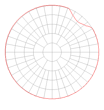 | ||||||||||||||||||
| Azimuth | Ratio | Azimuth | Ratio | Azimuth | Ratio | Azimuth | Ratio | ||||||||||||
| 0 | 1.000 | 10 | 1.000 | 20 | 1.000 | 30 | 0.900 | ||||||||||||
| 40 | 0.850 | 50 | 0.900 | 60 | 1.000 | 70 | 1.000 | ||||||||||||
| 80 | 1.000 | 90 | 1.000 | 100 | 1.000 | 110 | 1.000 | ||||||||||||
| 120 | 1.000 | 130 | 1.000 | 140 | 1.000 | 150 | 1.000 | ||||||||||||
| 160 | 1.000 | 170 | 1.000 | 180 | 1.000 | 190 | 1.000 | ||||||||||||
| 200 | 1.000 | 210 | 1.000 | 220 | 1.000 | 230 | 1.000 | ||||||||||||
| 240 | 1.000 | 250 | 1.000 | 260 | 1.000 | 270 | 1.000 | ||||||||||||
| 280 | 1.000 | 290 | 1.000 | 300 | 1.000 | 310 | 1.000 | ||||||||||||
| 320 | 1.000 | 330 | 1.000 | 340 | 1.000 | 350 | 1.000 | ||||||||||||
Structure Registration Number 1042780 Structure Type: TOWER Registered To: Henson Media of Union County, LLC Structure Address: Ky Us 60 1.6 Km Morganfield, KY County Name: Union County ASR Issued: 04/10/2019 Date Built: 12/03/2004 Site Elevation: 126.4 m (415 ft.) Structure Height: 92.4 m (303 ft.) Height Overall: 92.4 m (303 ft.) Overall Height AMSL: 218.8 m (718 ft.) FAA Determination: 08/21/2007 FAA Study #: 2007-ASO-4012-OE Paint & Light FAA Chapters: 1, 3, 12, 21 Continue As Is OM&L = PAINT/RED LIGHTS 37-40-04.2 N 87-55-46.1 W (NAD 83) 37-40-04.0 N 87-55-46.0 W (Converted to NAD 27) |
455 South Fourth Street, Suite 494 Louisville, KY 40202 Phone: 502-589-0060 | Date: 04/04/2016 Application Certifier HENSON MEDIA OF UNION COUNTY, LLC 1930 Bishop Lane Suite 1009 Louisville, KY 40218-1958 Applicant CHARLES M. ANDERSON 1519 Euclid Avenue Bowling Green, KY 42103 BROADCAST CONSULTANT JOHN F. GARZIGLIA Womble Carlyle Sandridge & Rice, Llp 1200 19th Street, N.w. Suite 500 Washington, DC 20036 | |||||||||||||||||