
FCCInfo.com
A Service of Cavell, Mertz & Associates, Inc.
(855) FCC-INFO
|
|
K250BN from 12/12/2013 |
|
|
||||||||||||||||
|
|
K250BN Channel: 250D 97.9 MHz Tulsa, Oklahoma Service: FX - A translator or application for a translator. Facility ID: 140389 Fac. Service: FX Programming Delivery Method: Unspecified Status: License Application Accepted: 07/18/2018 Application Granted: 08/07/2018 File Number: BMLFT-20180718AAU License Expires: 00/00/0000 Prefix Type: This is a modification of license for a translator Application Type: Minor Modification FCC Website Links: LMS Facility Details This Application CDBS Application Other K250BN Applications Other K250BN Applications in CDBS Including Superseded Applications Mailing Address Correspondence for K250BN Correspondence related to application BMLFT-20180718AAU Service Contour - Open Street Map or USGS Map (60 dBu) Service Contour - KML / Google Earth (60 dBu) Class: D, A Noncommercial educational operating with no more than 10W Site Location: 36-05-13.3 N 95-51-34.0 W (NAD 83) Site Location: 36-05-13.0 N 95-51-33.0 W (Converted to NAD 27) Effective Radiated Power: 0.25 kW Transmitter Output Power: 0.155 kW Antenna Center HAAT: 0 m Antenna Center AMSL: 285 m (935 ft.) Antenna Center HAG: 80 m (262 ft.) Site Elevation: 205 m. (673 ft.) Height Overall*: 91 m (299 ft.) (* As Filed In This Application, may differ from ASR Data, Below.) Directional Antenna Antenna Make/Model: None Antenna ID: 127895 Polarization:
| ||||||||||||||||||
| Antenna Data for Antenna Id: 127895 K250BN FX File: BMLFT-20180718AAU None - Service: FX | 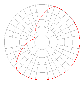 | ||||||||||||||||||
| Azimuth | Ratio | Azimuth | Ratio | Azimuth | Ratio | Azimuth | Ratio | ||||||||||||
| 0 | 0.692 | 10 | 0.866 | 20 | 1.000 | 30 | 1.000 | ||||||||||||
| 40 | 1.000 | 50 | 1.000 | 60 | 1.000 | 70 | 1.000 | ||||||||||||
| 80 | 1.000 | 90 | 1.000 | 100 | 1.000 | 110 | 1.000 | ||||||||||||
| 120 | 1.000 | 130 | 1.000 | 140 | 1.000 | 150 | 1.000 | ||||||||||||
| 160 | 1.000 | 170 | 1.000 | 180 | 1.000 | 190 | 1.000 | ||||||||||||
| 200 | 1.000 | 210 | 1.000 | 220 | 1.000 | 230 | 0.895 | ||||||||||||
| 240 | 0.715 | 250 | 0.571 | 260 | 0.456 | 270 | 0.364 | ||||||||||||
| 280 | 0.291 | 290 | 0.232 | 300 | 0.234 | 310 | 0.272 | ||||||||||||
| 320 | 0.283 | 330 | 0.353 | 340 | 0.441 | 350 | 0.553 | ||||||||||||
Structure Registration Number 1213828 [ASR Heights Differ from K250BN Application] Structure Type: LTOWER Registered To: American Towers LLC Structure Address: 10501 E. 54th Street (373732) Tulsa, OK County Name: Tulsa County ASR Issued: 01/31/2024 Date Built: 05/12/2000 Site Elevation: 204.5 m (671 ft.) Structure Height: 85.3 m (280 ft.) Height Overall: 91.4 m (300 ft.) Overall Height AMSL: 295.9 m (971 ft.) FAA Determination: 02/13/2023 FAA Study #: 2022-ASW-12282-OE FAA Circular #: 70/7460-1J Paint & Light FAA Chapters: 4, 6, 13 PRIOR STUDY 2006-ASW-1483-OE 36-05-13.4 N 95-51-33.6 W (NAD 83) 36-05-13.1 N 95-51-32.6 W (Converted to NAD 27) |
1232 E. 2nd St. Tulsa, OK 74120 Phone: 918-520-4447 | Date: 07/18/2018 Application Certifier RADIO LAS AMERICAS LLC 1232 E. 2nd St. Tulsa, OK 74120-2010 Applicant KEVIN T. FISHER Smith And Fisher 4791 Wintergreen Court Woodbridge, VA 22192 ENGINEERING CONSULTANT KATHLEEN VICTORY, ESQ. Fletcher, Heald & Hildreth, P.l.c. 1300 North 17th Street 11th Floor Arlington, VA 22209 | |||||||||||||||||