
FCCInfo.com
A Service of Cavell, Mertz & Associates, Inc.
(855) FCC-INFO
|
|
|
|
|
||||||||||||||||
|
|
K211CW Channel: 211D 90.1 MHz Hobbs, New Mexico Service: FX - A translator or application for a translator. Facility ID: 78075 Fac. Service: FX Programming Delivery Method: Unspecified Status: License Application Accepted: 03/24/1997 Application Granted: 04/27/1998 File Number: BLFT-19970324TB License Expires: 00/00/0000 Prefix Type: This is a license for a translator Application Type: License To Cover FCC Website Links: LMS Facility Details This Application CDBS Application Other K211CW Applications Other K211CW Applications in CDBS Including Superseded Applications Mailing Address Correspondence for K211CW Correspondence related to application BLFT-19970324TB Service Contour - Open Street Map or USGS Map (60 dBu) Service Contour - KML / Google Earth (60 dBu) Class: D, A Noncommercial educational operating with no more than 10W Site Location: 32-43-28.4 N 103-05-47.7 W (NAD 83) Site Location: 32-43-28.0 N 103-05-45.9 W (Converted to NAD 27) Effective Radiated Power: 0 kW Horiz. ; 0.057 kW Vert. Antenna Center HAAT: 99 m Horiz.; 0 m Vert. Antenna Center AMSL: 0 m Horiz.; 1197 m Vert. Antenna Center HAG: 0 m Horiz.; 94 m Vert. Calculated Site Elevation: m. Height Overall*: 164 m (538 ft.) (* As Filed In This Application, may differ from ASR Data, Below.) Directional Antenna Antenna Make/Model: None Antenna ID: 14858 Polarization:
| ||||||||||||||||||
| Antenna Data for Antenna Id: 14858 K211CW FX File: BLFT-19970324TB None - Service: FX | 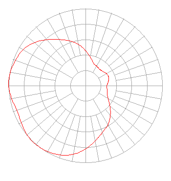 | ||||||||||||||||||
| Azimuth | Ratio | Azimuth | Ratio | Azimuth | Ratio | Azimuth | Ratio | ||||||||||||
| 0 | 0.453 | 10 | 0.371 | 20 | 0.308 | 30 | 0.291 | ||||||||||||
| 40 | 0.281 | 50 | 0.289 | 60 | 0.313 | 70 | 0.320 | ||||||||||||
| 80 | 0.301 | 90 | 0.277 | 100 | 0.285 | 110 | 0.300 | ||||||||||||
| 120 | 0.340 | 130 | 0.413 | 140 | 0.503 | 150 | 0.586 | ||||||||||||
| 160 | 0.646 | 170 | 0.730 | 180 | 0.823 | 190 | 0.905 | ||||||||||||
| 200 | 0.958 | 210 | 0.986 | 220 | 1.000 | 230 | 0.992 | ||||||||||||
| 240 | 0.964 | 250 | 0.946 | 260 | 0.975 | 270 | 1.000 | ||||||||||||
| 280 | 0.992 | 290 | 0.966 | 300 | 0.937 | 310 | 0.868 | ||||||||||||
| 320 | 0.779 | 330 | 0.691 | 340 | 0.620 | 350 | 0.546 | ||||||||||||
Structure Registration Number 1044868 [ASR Heights Differ from K211CW Application] Structure Type: GTOWER Registered To: American Towers LLC Structure Address: Intersection Us 62/180 & East Navajo Dr Hobbs, NM County Name: Lea County ASR Issued: 01/05/2021 Date Built: 01/01/1955 Site Elevation: 1106.4 m (3630 ft.) Structure Height: 157.3 m (516 ft.) Height Overall: 160.3 m (526 ft.) Overall Height AMSL: 1266.7 m (4156 ft.) FAA Determination: 02/25/2018 FAA Study #: 2017-ASW-17124-OE Paint & Light FAA Chapters: 1, 3, 4, 13, 21 Continue As Is OM&L = PAINT/RED LIGHTS 32-43-28.4 N 103-05-46.7 W (NAD 83) 32-43-28.0 N 103-05-44.9 W (Converted to NAD 27) |
3434 W. Kilbourn Ave. Milwaukee, WI 53208-3313 Phone: 414-935-3000 | Date: 03/24/1997 Application Certifier CHRISTIAN BROADCASTING ACADEMY INC. Christian Broadcasting Academy Inc. 3107 Eubank N.e. Suite #2 Albuquerque, NM 87111 Applicant | |||||||||||||||||