
FCCInfo.com
A Service of Cavell, Mertz & Associates, Inc.
(855) FCC-INFO
|
|
|
|  |
|
||||||||||||||||||
|
|
WDRC-FM Channel: 275B 102.9 MHz Hartford, Connecticut Service: FM - A full-service FM station or application. Facility ID: 7718 Fac. Service: FM Analog & Digital Status: License 73.215 Station Application Accepted: 09/29/2014 Application Granted: 10/10/2014 File Number: BLH-20140929AGJ License Expires: 00/00/0000 Prefix Type: This is a license for a commercial FM station Application Type: Amendment FCC Website Links: LMS Facility Details This Application CDBS Application Other WDRC-FM Applications Other WDRC-FM Applications in CDBS Including Superseded Applications Mailing Address Correspondence for WDRC-FM Correspondence related to application BLH-20140929AGJ Service Contour - Open Street Map or USGS Map (54 dBu) Service Contour - KML / Google Earth (54 dBu) Public Inspection Files History Cards for WDRC-FM Facility Type: FM STATION Class: B, A Zone I or I-A station; with 25kW-50kW ERP and a class contour distance 39km-52km Site Location: 41-33-44.4 N 72-50-38.4 W (NAD 83) Site Location: 41-33-44.0 N 72-50-40.0 W (Converted to NAD 27) Effective Radiated Power: 19.5 kW Horiz. ; 19.54 kW Vert. Transmitter Output Power: 6 kW Antenna Center HAAT: 247 m (810 ft.) Antenna Center AMSL: 345 m (1132 ft.) Antenna Center HAG: 33 m (108 ft.) Calculated Site Elevation: 312 m. (1024 ft.) Height Overall*: 41.2 m (135 ft.) (* As Filed In This Application, may differ from ASR Data, Below.) Directional Antenna Antenna Make/Model: Electronics Research Inc. LP-4E-DA, four sections Antenna ID: 118196 Polarization: | |||||||||||||||||||||
| Antenna Data for Antenna Id: 118196 WDRC-FM FM File: BLH-20140929AGJ Electronics Research Inc. - LP-4E-DA, four sections Service: FM | 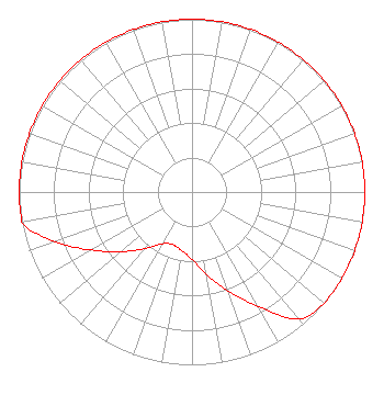 | |||||||||||||||||||||
| Azimuth | Ratio | Azimuth | Ratio | Azimuth | Ratio | Azimuth | Ratio | |||||||||||||||
| 0 | 1.000 | 10 | 1.000 | 20 | 1.000 | 30 | 1.000 | |||||||||||||||
| 40 | 1.000 | 50 | 1.000 | 60 | 1.000 | 70 | 1.000 | |||||||||||||||
| 80 | 1.000 | 90 | 1.000 | 100 | 1.000 | 110 | 1.000 | |||||||||||||||
| 120 | 1.000 | 130 | 1.000 | 140 | 0.958 | 150 | 0.763 | |||||||||||||||
| 160 | 0.610 | 170 | 0.486 | 180 | 0.388 | 190 | 0.345 | |||||||||||||||
| 200 | 0.324 | 210 | 0.347 | 220 | 0.428 | 230 | 0.537 | |||||||||||||||
| 240 | 0.672 | 250 | 0.842 | 260 | 1.000 | 270 | 1.000 | |||||||||||||||
| 280 | 1.000 | 290 | 1.000 | 300 | 1.000 | 310 | 1.000 | |||||||||||||||
| 320 | 1.000 | 330 | 1.000 | 340 | 1.000 | 350 | 1.000 | |||||||||||||||
Structure Registration Number 1045021 Structure Type: TOWER Registered To: Red Wolf Broadcasting Corporation Structure Address: West Peak Meriden, CT County Name: New Haven County ASR Issued: 04/23/2018 Date Built: 01/01/1972 Site Elevation: 312.4 m (1025 ft.) Structure Height: 41.2 m (135 ft.) Height Overall: 41.2 m (135 ft.) Overall Height AMSL: 353.6 m (1160 ft.) Paint & Light FAA Chapters: None 41-33-44.0 N 72-50-38.0 W (NAD 83) 41-33-43.6 N 72-50-39.6 W (Converted to NAD 27) |
Po Box 357 758 Colonel Ledyard Highway Ledyard, CT 06339 Phone: 202-747-1694 Corporation | Date: 09/29/2014 Application Certifier CONNOISSEUR MEDIA LICENSES, LLC 180 Post Road East Suite 201 Westport, CT 06880 Applicant W. JEFFREY REYNOLDS Du Treil, Lundin & Rackley, Inc. 201 Fletcher Avenue Sarasota, FL 34237-6019 TECHNICAL CONSULTANT DAVID D. OXENFORD Wilkinson Barker Knauer, Llp | ||||||||||||||||||||
|
| |||||||||||||||||||||