
FCCInfo.com
A Service of Cavell, Mertz & Associates, Inc.
(855) FCC-INFO
|
|
|
|
|
||||||||||||||||
|
|
W287BY Channel: 287D 105.3 MHz Rockford, Illinois Service: FX - A translator or application for a translator. Facility ID: 151837 Fac. Service: FX Programming Delivery Method: Unspecified Status: License Application Accepted: 06/02/2016 Application Granted: 06/23/2016 File Number: BLFT-20160602AAY License Expires: 00/00/0000 Prefix Type: This is a license for a translator Application Type: License To Cover FCC Website Links: LMS Facility Details This Application CDBS Application Other W287BY Applications Other W287BY Applications in CDBS Including Superseded Applications Mailing Address Correspondence for W287BY Correspondence related to application BLFT-20160602AAY Service Contour - Open Street Map or USGS Map (60 dBu) Service Contour - KML / Google Earth (60 dBu) Class: D, A Noncommercial educational operating with no more than 10W Site Location: 42-19-48.1 N 89-04-58.4 W (NAD 83) Site Location: 42-19-48.0 N 89-04-58.0 W (Converted to NAD 27) Effective Radiated Power: 0.135 kW Transmitter Output Power: 0.45 kW Antenna Center HAAT: 0 m Antenna Center AMSL: 322 m (1056 ft.) Antenna Center HAG: 90 m (295 ft.) Site Elevation: 232 m. (761 ft.) Height Overall*: 91 m (299 ft.) (* As Filed In This Application, may differ from ASR Data, Below.) Directional Antenna Antenna Make/Model: None Antenna ID: 123649 Polarization:
| ||||||||||||||||||
| Antenna Data for Antenna Id: 123649 W287BY FX File: BLFT-20160602AAY None - Service: FX Pattern and Field Values Include a 335° Clockwise Rotation | 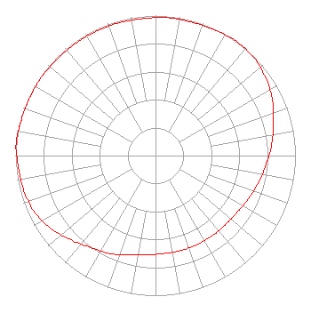 | ||||||||||||||||||
| Azimuth | Ratio | Azimuth | Ratio | Azimuth | Ratio | Azimuth | Ratio | ||||||||||||
| 5 | 0.988 | 15 | 0.988 | 25 | 0.992 | 35 | 1.000 | ||||||||||||
| 45 | 0.991 | 55 | 0.963 | 65 | 0.923 | 75 | 0.873 | ||||||||||||
| 85 | 0.832 | 95 | 0.792 | 105 | 0.762 | 115 | 0.732 | ||||||||||||
| 125 | 0.710 | 135 | 0.702 | 145 | 0.702 | 155 | 0.702 | ||||||||||||
| 165 | 0.702 | 175 | 0.702 | 185 | 0.712 | 195 | 0.732 | ||||||||||||
| 205 | 0.772 | 215 | 0.802 | 225 | 0.853 | 235 | 0.909 | ||||||||||||
| 245 | 0.953 | 255 | 0.973 | 265 | 0.983 | 275 | 1.000 | ||||||||||||
| 285 | 0.992 | 295 | 0.988 | 305 | 0.988 | 315 | 0.983 | ||||||||||||
| 325 | 0.983 | 335 | 0.983 | 345 | 0.983 | 355 | 0.983 | ||||||||||||
Structure Registration Number 1019526 Structure Type: TOWER Registered To: VCY America, Inc. Structure Address: 2272 Elmwood Rd Rockford, IL County Name: Winnebago County ASR Issued: 05/26/2022 Date Built: 09/29/1962 Site Elevation: 231.7 m (760 ft.) Structure Height: 90.2 m (296 ft.) Height Overall: 91.1 m (299 ft.) Overall Height AMSL: 322.8 m (1059 ft.) Paint & Light FAA Chapters: 1, 3, 11, 21 42-19-48.0 N 89-04-58.0 W (NAD 83) 42-19-47.9 N 89-04-57.6 W (Converted to NAD 27) |
3434 West Kilbourn Ave Milwaukee, WI 53208 Phone: 414-935-3000 Not-for-Profit | Date: 06/02/2016 Application Certifier ANGELO JOSEPH SALVI 2272 Elmwood Road Rockford, IL 61103 Applicant JOHN NEELY, ESQ. Miller And Neely, P.c. Suite 203 3750 University Blvd., West Kensington, MD 20895 CHARLES INGLE 5561 Hodges Run Roscoe, IL 61073 TECHNICAL CONSULTANT | |||||||||||||||||