
FCCInfo.com
A Service of Cavell, Mertz & Associates, Inc.
(855) FCC-INFO
|
|
W201DQ from 10/23/2013 |
|
|
||||||||||||||||
|
|
W201DQ Channel: 201D 88.1 MHz Utica, New York Service: FX - A translator or application for a translator. Facility ID: 139047 Fac. Service: FX Programming Delivery Method: Unspecified Status: License Application Accepted: 05/08/2019 Application Granted: 05/13/2019 File Number: BLFT-20190508AAE License Expires: 00/00/0000 Prefix Type: This is a license for a translator Application Type: License To Cover FCC Website Links: LMS Facility Details This Application CDBS Application Other W201DQ Applications Other W201DQ Applications in CDBS Including Superseded Applications Mailing Address Correspondence for W201DQ Correspondence related to application BLFT-20190508AAE Service Contour - Open Street Map or USGS Map (60 dBu) Service Contour - KML / Google Earth (60 dBu) Class: D, A Noncommercial educational operating with no more than 10W Site Location: 43-02-15.3 N 75-11-43.6 W (NAD 83) Site Location: 43-02-15.0 N 75-11-45.0 W (Converted to NAD 27) Effective Radiated Power: 0.01 kW Transmitter Output Power: 0.002 kW Antenna Center HAAT: 0 m Antenna Center AMSL: 463 m (1519 ft.) Antenna Center HAG: 30 m (98 ft.) Site Elevation: 433 m. (1421 ft.) Height Overall*: 56 m (184 ft.) (* As Filed In This Application, may differ from ASR Data, Below.) Directional Antenna Antenna Make/Model: None Antenna ID: 133497 Polarization:
| ||||||||||||||||||
| Antenna Data for Antenna Id: 133497 W201DQ FX File: BLFT-20190508AAE None - Service: FX Pattern and Field Values Include a 290° Clockwise Rotation | 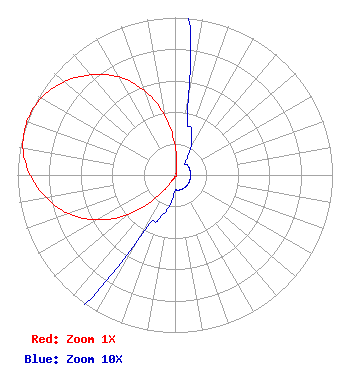 | ||||||||||||||||||
| Azimuth | Ratio | Azimuth | Ratio | Azimuth | Ratio | Azimuth | Ratio | ||||||||||||
| 0 | 0.190 | 10 | 0.050 | 20 | 0.030 | 30 | 0.020 | ||||||||||||
| 40 | 0.010 | 50 | 0.010 | 60 | 0.010 | 70 | 0.010 | ||||||||||||
| 80 | 0.010 | 90 | 0.010 | 100 | 0.010 | 110 | 0.010 | ||||||||||||
| 120 | 0.010 | 130 | 0.010 | 140 | 0.010 | 150 | 0.010 | ||||||||||||
| 160 | 0.010 | 170 | 0.010 | 180 | 0.010 | 190 | 0.020 | ||||||||||||
| 200 | 0.030 | 210 | 0.050 | 220 | 0.190 | 230 | 0.390 | ||||||||||||
| 240 | 0.570 | 250 | 0.720 | 260 | 0.830 | 270 | 0.920 | ||||||||||||
| 280 | 0.980 | 290 | 1.000 | 300 | 0.980 | 310 | 0.920 | ||||||||||||
| 320 | 0.830 | 330 | 0.720 | 340 | 0.570 | 350 | 0.390 | ||||||||||||
Structure Registration Number 1253558 Structure Type: TOWER Structure Address: Nad27 Coord. 43-02-15 N X 75-11-45 W Utica, NY County Name: Herkimer County ASR Issued: 05/23/2006 Date Built: 05/23/2006 Site Elevation: 433 m (1421 ft.) Structure Height: 56 m (184 ft.) Height Overall: 56 m (184 ft.) Overall Height AMSL: 489 m (1604 ft.) FAA Determination: 05/22/2006 FAA Study #: 2006-AEA-1908-OE FAA Circular #: 70/7460-1K Paint & Light FAA Chapters: 3, 4, 5, 12 PRIOR STUDY 1992-AEA-694-OE 43-02-14.9 N 75-11-43.5 W (NAD 83) 43-02-14.6 N 75-11-44.9 W (Converted to NAD 27) |
65 Kings Road Buskirk, NY 12028 Phone: 518-686-0975 | Date: 05/08/2019 Application Certifier NORTHEAST GOSPEL BROADCASTING, INC. 65 Kings Rd Buskirk, NY 12028 Applicant RICHARD C GOETZ Rl Mediasystems 135 N Country Club Dr Hendersonville, TN 37075 BROADCAST CONSULTANT BRIAN LARSON Northeast Gospel Broadcasting, Inc. 65 King Rd Buskirk, NY 12028 | |||||||||||||||||