
FCCInfo.com
A Service of Cavell, Mertz & Associates, Inc.
(855) FCC-INFO
|
|
|
|  |
|
|||||||||||||||
|
|
WUND-FM Channel: 205C0 88.9 MHz Manteo, North Carolina Service: FM - A full-service FM station or application. Facility ID: 89274 Fac. Service: FM Status: License Application Accepted: 08/12/2003 Application Granted: 08/18/2004 File Number: BLED-20030812ABB License Expires: 00/00/0000 Prefix Type: This is a license for a noncommercial educational FM station Application Type: License To Cover FCC Website Links: LMS Facility Details This Application CDBS Application Other WUND-FM Applications Other WUND-FM Applications in CDBS Including Superseded Applications Mailing Address Correspondence for WUND-FM Correspondence related to application BLED-20030812ABB Service Contour - Open Street Map or USGS Map (60 dBu) Service Contour - KML / Google Earth (60 dBu) Public Inspection Files Facility Type: NON-COMMERCIAL EDUC. FM Class: C0, C0 Site Location: 35-54-00.6 N 76-20-43.8 W (NAD 83) Site Location: 35-54-00.0 N 76-20-45.0 W (Converted to NAD 27) Effective Radiated Power: 50 kW Horiz. ; 47 kW Vert. Transmitter Output Power: 12.3 kW Antenna Center HAAT: 418 m (1371 ft.) Antenna Center AMSL: 419 m (1375 ft.) Antenna Center HAG: 417 m (1368 ft.) Site Elevation: 2 m. (7 ft.) Height Overall*: 501 m (1644 ft.) (* As Filed In This Application, may differ from ASR Data, Below.) Directional Antenna Antenna Make/Model: SL 6016-3/2-DA Antenna ID: 41894 Polarization:
| ||||||||||||||||||
| Antenna Data for Antenna Id: 41894 WUND-FM FM File: BLED-20030812ABB SL - 6016-3/2-DA Service: FM | 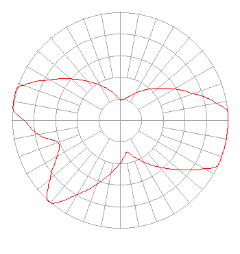 | ||||||||||||||||||
| Azimuth | Ratio | Azimuth | Ratio | Azimuth | Ratio | Azimuth | Ratio | ||||||||||||
| 0 | 0.189 | 1 | 0.185 | 10 | 0.194 | 20 | 0.231 | ||||||||||||
| 30 | 0.290 | 40 | 0.365 | 50 | 0.459 | 60 | 0.577 | ||||||||||||
| 70 | 0.716 | 75 | 0.819 | 80 | 0.913 | 85 | 1.000 | ||||||||||||
| 90 | 1.000 | 100 | 1.000 | 110 | 1.000 | 115 | 1.000 | ||||||||||||
| 120 | 0.896 | 130 | 0.712 | 140 | 0.566 | 150 | 0.450 | ||||||||||||
| 160 | 0.358 | 167 | 0.305 | 168 | 0.305 | 170 | 0.319 | ||||||||||||
| 180 | 0.401 | 190 | 0.504 | 200 | 0.634 | 210 | 0.798 | ||||||||||||
| 220 | 1.000 | 222 | 1.000 | 230 | 0.843 | 240 | 0.670 | ||||||||||||
| 250 | 0.610 | 260 | 0.767 | 270 | 0.885 | 276 | 1.000 | ||||||||||||
| 280 | 1.000 | 287 | 1.000 | 290 | 0.940 | 300 | 0.747 | ||||||||||||
| 310 | 0.594 | 320 | 0.472 | 330 | 0.375 | 340 | 0.298 | ||||||||||||
| 350 | 0.237 | ||||||||||||||||||
Structure Registration Number 1063239 [ASR Heights Differ from WUND-FM Application] Structure Type: GTOWER Registered To: UNIVERSITY OF NORTH CAROLINA Structure Address: 521 Raccoon Road Creswell, NC County Name: Tyrrell County ASR Issued: 11/21/2023 Date Built: 01/26/2024 Site Elevation: 1.8 m (6 ft.) Structure Height: 479.8 m (1574 ft.) Height Overall: 499.9 m (1640 ft.) Overall Height AMSL: 501.7 m (1646 ft.) FAA Determination: 10/31/2023 FAA Study #: 2022-ASO-40934-OE FAA Circular #: 70/7460-1M Paint & Light FAA Chapters: 4, 9, 15 PRIOR STUDY 1996-ASO-113-OE 35-53-58.5 N 76-20-46.5 W (NAD 83) 35-53-57.9 N 76-20-47.7 W (Converted to NAD 27) |
Campus Box 0915 120 Friday Center Drive Chapel Hill, NC 27517-9495 Phone: 919-445-9150 Government Entity | Date: 08/12/2003 Application Certifier THE BOARD OF TRUSTEES OF THE UNIVERSITY OF NC AT CHAPEL HILL Campus Box 0915, 120 Friday Center Drive Chapel Hill, NC 27517-9495 Applicant TIMOTHY L. WARNER, P.E. Timothy L. Warner, Inc. Post Office Box 8045 Asheville, NC 28814-8045 TECHNICAL CONSULTANT MARCUS W. TRATHEN Brooks, Pierce, Et Al. | |||||||||||||||||