
FCCInfo.com
A Service of Cavell, Mertz & Associates, Inc.
(855) FCC-INFO
|
|
K260CX from 12/05/2013 |
|
|
||||||||||||||||
|
|
K260CX Channel: 260D 99.9 MHz Mckinney, Texas Service: FX - A translator or application for a translator. Facility ID: 142902 Fac. Service: FX Programming Delivery Method: Unspecified Status: License Application Accepted: 01/11/2018 Application Granted: 02/02/2018 File Number: BLFT-20180111AEH License Expires: 00/00/0000 Prefix Type: This is a license for a translator Application Type: License To Cover FCC Website Links: LMS Facility Details This Application CDBS Application Other K260CX Applications Other K260CX Applications in CDBS Including Superseded Applications Mailing Address Correspondence for K260CX Correspondence related to application BLFT-20180111AEH Service Contour - Open Street Map or USGS Map (60 dBu) Service Contour - KML / Google Earth (60 dBu) Class: D, A Noncommercial educational operating with no more than 10W Site Location: 33-03-50.4 N 96-35-03.0 W (NAD 83) Site Location: 33-03-50.0 N 96-35-02.0 W (Converted to NAD 27) Effective Radiated Power: 0.25 kW Transmitter Output Power: 0.135 kW Antenna Center HAAT: 0 m Antenna Center AMSL: 306 m (1004 ft.) Antenna Center HAG: 131 m (430 ft.) Site Elevation: 175 m. (574 ft.) Height Overall*: 145 m (476 ft.) (* As Filed In This Application, may differ from ASR Data, Below.) Directional Antenna Antenna Make/Model: None Antenna ID: 129331 Polarization:
| ||||||||||||||||||
| Antenna Data for Antenna Id: 129331 K260CX FX File: BLFT-20180111AEH None - Service: FX Pattern and Field Values Include a 330° Clockwise Rotation | 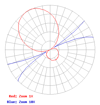 | ||||||||||||||||||
| Azimuth | Ratio | Azimuth | Ratio | Azimuth | Ratio | Azimuth | Ratio | ||||||||||||
| 0 | 0.810 | 10 | 0.680 | 20 | 0.530 | 30 | 0.380 | ||||||||||||
| 40 | 0.230 | 50 | 0.100 | 60 | 0.010 | 70 | 0.080 | ||||||||||||
| 80 | 0.130 | 90 | 0.160 | 100 | 0.180 | 110 | 0.200 | ||||||||||||
| 120 | 0.220 | 130 | 0.240 | 140 | 0.250 | 150 | 0.260 | ||||||||||||
| 160 | 0.250 | 170 | 0.240 | 180 | 0.210 | 190 | 0.190 | ||||||||||||
| 200 | 0.170 | 210 | 0.150 | 220 | 0.120 | 230 | 0.080 | ||||||||||||
| 240 | 0.010 | 250 | 0.090 | 260 | 0.220 | 270 | 0.370 | ||||||||||||
| 280 | 0.520 | 290 | 0.670 | 300 | 0.800 | 310 | 0.910 | ||||||||||||
| 320 | 0.970 | 330 | 1.000 | 340 | 0.980 | 350 | 0.910 | ||||||||||||
Structure Registration Number 1047140 [ASR Heights Differ from K260CX Application] Structure Type: GTOWER Registered To: American Towers LLC Structure Address: 1655 Stinson Road (lucas #90316) Allen, TX County Name: Collin County ASR Issued: 10/25/2022 Date Built: 10/04/2007 Site Elevation: 175.3 m (575 ft.) Structure Height: 138.4 m (454 ft.) Height Overall: 144.5 m (474 ft.) Overall Height AMSL: 319.8 m (1049 ft.) FAA Determination: 10/17/2022 FAA Study #: 2021-ASW-18151-OE FAA Circular #: 70/7460-1K Paint & Light FAA Chapters: 4, 8, 12 OM&L to remain the same as prior study = A MED-DUAL SYSTEM 33-03-50.4 N 96-35-03.0 W (NAD 83) 33-03-50.0 N 96-35-02.0 W (Converted to NAD 27) |
4440 W. Airport Freeway Irving, TX 75062 Phone: 972-904-5904 Limited Liability Company | Date: 01/11/2018 Application Certifier VIKRAM SHAH BRODCASTING INC. 3226 Ridge Oak Dr. Garland, TX 75044 Applicant HOMERO LOZANO 311 S Windomere Ave. Dallas, TX 75208 CONSULTING ENGINEER DAN J. ALPERT The Law Office Of Dan J. Alpert 2120 N. 21st Rd. Arlington, VA 22201 | |||||||||||||||||