
FCCInfo.com
A Service of Cavell, Mertz & Associates, Inc.
(855) FCC-INFO
|
|
W263CU from 05/24/2004 |
|
|
||||||||||||||||
|
|
W263CU Channel: 263D 100.5 MHz Hyannis, Massachusetts Service: FX - A translator or application for a translator. Facility ID: 140925 Fac. Service: FX Programming Delivery Method: Unspecified Status: License Application Accepted: 06/05/2014 Application Granted: 07/14/2014 File Number: BLFT-20140605AAO License Expires: 00/00/0000 Prefix Type: This is a license for a translator Application Type: License To Cover FCC Website Links: LMS Facility Details This Application CDBS Application Other W263CU Applications Other W263CU Applications in CDBS Including Superseded Applications Mailing Address Correspondence for W263CU Correspondence related to application BLFT-20140605AAO Service Contour - Open Street Map or USGS Map (60 dBu) Service Contour - KML / Google Earth (60 dBu) Class: D, A Noncommercial educational operating with no more than 10W Site Location: 41-41-20.4 N 70-20-47.1 W (NAD 83) Site Location: 41-41-20.0 N 70-20-49.0 W (Converted to NAD 27) Effective Radiated Power: 0.25 kW Transmitter Output Power: 0.31 kW Antenna Center HAAT: 0 m Antenna Center AMSL: 151 m (495 ft.) Antenna Center HAG: 113 m (371 ft.) Site Elevation: 38 m. (125 ft.) Height Overall*: 128 m (420 ft.) (* As Filed In This Application, may differ from ASR Data, Below.) Directional Antenna Antenna Make/Model: None Antenna ID: 118020 Polarization:
| ||||||||||||||||||
| Antenna Data for Antenna Id: 118020 W263CU FX File: BLFT-20140605AAO None - Service: FX | 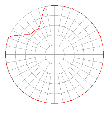 | ||||||||||||||||||
| Azimuth | Ratio | Azimuth | Ratio | Azimuth | Ratio | Azimuth | Ratio | ||||||||||||
| 0 | 1.000 | 10 | 1.000 | 20 | 1.000 | 30 | 1.000 | ||||||||||||
| 40 | 1.000 | 50 | 1.000 | 60 | 1.000 | 70 | 1.000 | ||||||||||||
| 80 | 1.000 | 90 | 1.000 | 100 | 1.000 | 110 | 1.000 | ||||||||||||
| 120 | 1.000 | 130 | 1.000 | 140 | 1.000 | 150 | 1.000 | ||||||||||||
| 160 | 1.000 | 170 | 1.000 | 180 | 1.000 | 190 | 1.000 | ||||||||||||
| 200 | 1.000 | 210 | 1.000 | 220 | 1.000 | 230 | 1.000 | ||||||||||||
| 240 | 1.000 | 250 | 1.000 | 260 | 1.000 | 270 | 1.000 | ||||||||||||
| 280 | 1.000 | 290 | 1.000 | 300 | 0.786 | 310 | 0.646 | ||||||||||||
| 320 | 0.632 | 330 | 0.632 | 340 | 0.775 | 350 | 1.000 | ||||||||||||
Structure Registration Number 1231034 Structure Type: GTOWER Registered To: Pinnacle Towers LLC Structure Address: 749 Oak Street West Barnstable, MA County Name: Barnstable County ASR Issued: 01/05/2021 Date Built: 07/22/2021 Site Elevation: 38.1 m (125 ft.) Structure Height: 118.3 m (388 ft.) Height Overall: 128.3 m (421 ft.) Overall Height AMSL: 166.4 m (546 ft.) FAA Determination: 12/17/2020 FAA Study #: 2020-ANE-6698-OE FAA Circular #: 70/7460-1M Paint & Light FAA Chapters: 4, 8, 15 PRIOR STUDY 2013-ANE-505-OE 41-41-20.1 N 70-20-47.1 W (NAD 83) 41-41-19.7 N 70-20-49.0 W (Converted to NAD 27) |
253 Old Stockbridge Road Lenox, MA 01240 Phone: 917-846-3930 Limited Liability Company | Date: 06/05/2014 Application Certifier NANTUCKET PUBLIC RADIO, INC. P.o. Box 2185 Nantucket, MA 02584 Applicant JOHN H. GARABEDIAN 24 Fairview Drive South Borough, MA 01772 ENGINEERING CONSULTANT DAVID G. O'NEIL, ESQ. Rini O'neil, Pc 1200 New Hampshire Avenue, Nw Suite 600 Washington, DC 20036 | |||||||||||||||||