
FCCInfo.com
A Service of Cavell, Mertz & Associates, Inc.
(855) FCC-INFO
|
|
WCIE from 08/02/1996 WCIE from 06/07/1996 WCIE from 11/16/1983 |
|  |
|
|||||||||||||||
|
|
WCIE Channel: 218C0 91.5 MHz New Port Richey, Florida Service: FM - A full-service FM station or application. Facility ID: 60262 Fac. Service: FM Analog & Digital Status: License Application Accepted: 11/21/2013 Application Granted: 12/05/2013 File Number: BLED-20131121AVZ License Expires: 00/00/0000 Prefix Type: This is a license for a noncommercial educational FM station Application Type: License To Cover FCC Website Links: LMS Facility Details This Application CDBS Application Other WCIE Applications Other WCIE Applications in CDBS Including Superseded Applications Mailing Address Correspondence for WCIE Correspondence related to application BLED-20131121AVZ Service Contour - Open Street Map or USGS Map (60 dBu) Service Contour - KML / Google Earth (60 dBu) Public Inspection Files Facility Type: NON-COMMERCIAL EDUC. FM Class: C0, C0 Site Location: 28-10-57.0 N 82-46-05.3 W (NAD 83) Site Location: 28-10-56.0 N 82-46-05.9 W (Converted to NAD 27) Effective Radiated Power: 75 kW Transmitter Output Power: 14.35 kW Antenna Center HAAT: 388.5 m (1275 ft.) Antenna Center AMSL: 391.1 m (1283 ft.) Antenna Center HAG: 388.6 m (1275 ft.) Calculated Site Elevation: 2.5 m. (8 ft.) Height Overall*: 466 m (1529 ft.) (* As Filed In This Application, may differ from ASR Data, Below.) Directional Antenna Antenna Make/Model: Electronics Research Inc. 1191-4/CP-DA, 4 sections Antenna ID: 113702 Polarization:
| ||||||||||||||||||
| Antenna Data for Antenna Id: 113702 WCIE FM File: BLED-20131121AVZ Electronics Research Inc. - 1191-4/CP-DA, 4 sections Service: FM | 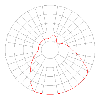 | ||||||||||||||||||
| Azimuth | Ratio | Azimuth | Ratio | Azimuth | Ratio | Azimuth | Ratio | ||||||||||||
| 0 | 0.269 | 10 | 0.331 | 20 | 0.331 | 30 | 0.280 | ||||||||||||
| 33 | 0.262 | 40 | 0.224 | 45 | 0.224 | 50 | 0.224 | ||||||||||||
| 60 | 0.281 | 70 | 0.353 | 80 | 0.420 | 90 | 0.490 | ||||||||||||
| 100 | 0.615 | 110 | 0.773 | 120 | 0.966 | 130 | 1.000 | ||||||||||||
| 135 | 1.000 | 140 | 1.000 | 150 | 1.000 | 160 | 1.000 | ||||||||||||
| 170 | 1.000 | 180 | 1.000 | 190 | 1.000 | 200 | 1.000 | ||||||||||||
| 210 | 0.860 | 220 | 0.690 | 225 | 0.616 | 230 | 0.550 | ||||||||||||
| 240 | 0.442 | 250 | 0.355 | 260 | 0.285 | 270 | 0.260 | ||||||||||||
| 280 | 0.260 | 290 | 0.260 | 300 | 0.260 | 310 | 0.260 | ||||||||||||
| 315 | 0.260 | 320 | 0.260 | 330 | 0.260 | 340 | 0.260 | ||||||||||||
| 350 | 0.251 | ||||||||||||||||||
Structure Registration Number 1246632 [ASR Heights Differ from WCIE Application] Structure Type: GTOWER Registered To: Vertical Bridge CC FM, LLC Structure Address: 3000 Atlantis Drive Holiday, FL County Name: Pasco County ASR Issued: 12/19/2018 Date Built: 06/30/2009 Site Elevation: 2.1 m (7 ft.) Structure Height: 465.2 m (1526 ft.) Height Overall: 468.1 m (1536 ft.) Overall Height AMSL: 470.2 m (1543 ft.) FAA Determination: 11/12/2015 FAA Study #: 2015-ASO-12897-OE FAA Circular #: 70/7460-1K Paint & Light FAA Chapters: 4, 7, 12 PRIOR STUDY 2006-ASO-4028-OE 28-10-57.4 N 82-46-04.1 W (NAD 83) 28-10-56.4 N 82-46-04.7 W (Converted to NAD 27) |
Po Box 7217 Lakeland, FL 33807 Phone: 863-644-3464 Not-for-Profit | Date: 11/21/2013 Application Certifier RADIO TRAINING NETWORK, INC. P.o. Box 7217 Lakeland, FL 33807-7217 Applicant R. STUART GRAHAM Graham Brock, Inc. P. O. Box 24466 St. Simons Island, GA 31522-7466 TECHNICAL CONSULTANT A. WRAY FITCH III Gammon & Grange, P.c. | |||||||||||||||||