
FCCInfo.com
A Service of Cavell, Mertz & Associates, Inc.
(855) FCC-INFO
|
|
|
|  |
|
|||||||||||||||
|
|
WXTU Channel: 223B 92.5 MHz Philadelphia, Pennsylvania Service: FM - A full-service FM station or application. Facility ID: 74213 Fac. Service: FM Analog & Digital Status: License Application Accepted: 10/17/2003 Application Granted: 06/14/2006 File Number: BLH-20031017ACG License Expires: 00/00/0000 Prefix Type: This is a license for a commercial FM station Application Type: Amendment FCC Website Links: LMS Facility Details This Application CDBS Application Other WXTU Applications Other WXTU Applications in CDBS Including Superseded Applications Mailing Address Correspondence for WXTU Correspondence related to application BLH-20031017ACG Service Contour - Open Street Map or USGS Map (54 dBu) Service Contour - KML / Google Earth (54 dBu) Public Inspection Files History Cards for WXTU Facility Type: FM STATION Class: B, A Zone I or I-A station; with 25kW-50kW ERP and a class contour distance 39km-52km Site Location: 40-02-19.4 N 75-14-12.6 W (NAD 83) Site Location: 40-02-19.0 N 75-14-14.0 W (Converted to NAD 27) Effective Radiated Power: 15 kW Transmitter Output Power: 10.75 kW Antenna Center HAAT: 279 m (915 ft.) Antenna Center AMSL: 343 m (1125 ft.) Antenna Center HAG: 267 m (876 ft.) Site Elevation: 76 m. (249 ft.) Height Overall*: 352.9 m (1158 ft.) (* As Filed In This Application, may differ from ASR Data, Below.) Directional Antenna Antenna Make/Model: TEN 756-664, two sections Antenna ID: 34564 Polarization: | ||||||||||||||||||
| Antenna Data for Antenna Id: 34564 WXTU FM File: BLH-20031017ACG TEN - 756-664, two sections Service: FM | 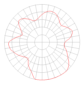 | ||||||||||||||||||
| Azimuth | Ratio | Azimuth | Ratio | Azimuth | Ratio | Azimuth | Ratio | ||||||||||||
| 0 | 0.729 | 10 | 0.820 | 20 | 0.850 | 30 | 0.804 | ||||||||||||
| 40 | 0.720 | 45 | 0.684 | 50 | 0.680 | 60 | 0.772 | ||||||||||||
| 70 | 0.850 | 80 | 0.770 | 90 | 0.613 | 100 | 0.600 | ||||||||||||
| 110 | 0.690 | 120 | 0.790 | 130 | 0.920 | 135 | 0.972 | ||||||||||||
| 140 | 1.000 | 150 | 1.000 | 160 | 1.000 | 170 | 1.000 | ||||||||||||
| 180 | 1.000 | 190 | 1.000 | 200 | 0.830 | 210 | 0.716 | ||||||||||||
| 220 | 0.580 | 225 | 0.579 | 230 | 0.610 | 240 | 0.700 | ||||||||||||
| 250 | 0.790 | 260 | 0.870 | 270 | 0.871 | 280 | 0.695 | ||||||||||||
| 290 | 0.560 | 300 | 0.646 | 310 | 0.810 | 315 | 0.832 | ||||||||||||
| 320 | 0.800 | 330 | 0.700 | 340 | 0.600 | 350 | 0.630 | ||||||||||||
Structure Registration Number 1026755 [ASR Heights Differ from WXTU Application] Structure Type: GTOWER Registered To: American Towers LLC Structure Address: 216 Paoli Ave (010110) Philadelphia, PA County Name: Philadelphia County ASR Issued: 06/09/2015 Date Built: 08/01/2008 Site Elevation: 75.6 m (248 ft.) Structure Height: 338.9 m (1112 ft.) Height Overall: 360.5 m (1183 ft.) Overall Height AMSL: 436.1 m (1431 ft.) FAA Determination: 04/23/2015 FAA Study #: 2015-AEA-640-OE FAA Circular #: 70/7460-1K Paint & Light FAA Chapters: 3, 4, 5, 12 PRIOR STUDY 2013-AEA-5467-OE 40-02-19.7 N 75-14-12.8 W (NAD 83) 40-02-19.3 N 75-14-14.2 W (Converted to NAD 27) |
3033 Riviera Drive Suite 200 Naples, FL 34103 Phone: 239-263-5000 Limited Liability Company | Date: 10/17/2003 Application Certifier WXTU LICENSE LIMITED PARTNERSHIP 3033 Riviera Drive Suite 200 Naples, FL 34103 Applicant JEFFERSON G. BROCK Graham Brock, Inc. P.o. Box 24466 St. Simons Island, GA 31522-7466 TECHNICAL CONSULTANT DENNIS P. CORBETT, ESQ. Leventhal Senter & Lerman Pllc | |||||||||||||||||
| |||||||||||||||||||