
FCCInfo.com
A Service of Cavell, Mertz & Associates, Inc.
(855) FCC-INFO
|
|
|
|  |
|
|||||||||||||||
|
|
WWCJ Channel: 206B1 89.1 MHz Cape May, New Jersey Service: FM - A full-service FM station or application. Facility ID: 41201 Fac. Service: FM Analog & Digital Status: License Application Accepted: 06/12/2012 Application Granted: 06/19/2012 File Number: BLED-20120612ABD License Expires: 00/00/0000 Prefix Type: This is a license for a noncommercial educational FM station Application Type: License To Cover FCC Website Links: LMS Facility Details This Application CDBS Application Other WWCJ Applications Other WWCJ Applications in CDBS Including Superseded Applications Mailing Address Correspondence for WWCJ Correspondence related to application BLED-20120612ABD Service Contour - Open Street Map or USGS Map (60 dBu) Service Contour - KML / Google Earth (60 dBu) Public Inspection Files Facility Type: NON-COMMERCIAL EDUC. FM Class: B1, A Zone I or I-A station; with 6kW-25kW ERP and a class contour distance 28km-39km Site Location: 39-07-28.0 N 74-45-55.0 W (NAD 83) Site Location: 39-07-27.6 N 74-45-56.4 W (Converted to NAD 27) Effective Radiated Power: 8.2 kW Horiz. ; 13.5 kW Vert. Transmitter Output Power: 6.07 kW Antenna Center HAAT: 117.4 m (385 ft.) Antenna Center AMSL: 118.2 m (388 ft.) Antenna Center HAG: 116.7 m (383 ft.) Calculated Site Elevation: 1.5 m. (5 ft.) Height Overall*: 133.2 m (437 ft.) (* As Filed In This Application, may differ from ASR Data, Below.) Directional Antenna Antenna Make/Model: Systems With Reliability Inc. FMI3D/4-DA, four sections, 0.5 wavelength spaced Antenna ID: 109178 Polarization:
| ||||||||||||||||||
| Antenna Data for Antenna Id: 109178 WWCJ FM File: BLED-20120612ABD Systems With Reliability Inc. - FMI3D/4-DA, four sections, 0.5 wavelength spaced Service: FM | 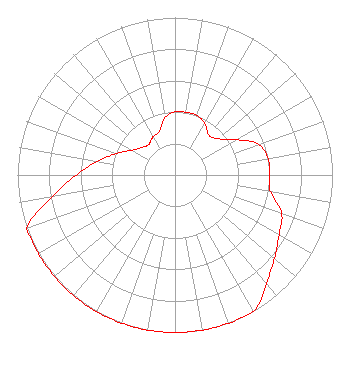 | ||||||||||||||||||
| Azimuth | Ratio | Azimuth | Ratio | Azimuth | Ratio | Azimuth | Ratio | ||||||||||||
| 0 | 0.401 | 10 | 0.405 | 20 | 0.403 | 30 | 0.378 | ||||||||||||
| 40 | 0.332 | 50 | 0.357 | 60 | 0.449 | 70 | 0.566 | ||||||||||||
| 80 | 0.600 | 90 | 0.600 | 100 | 0.615 | 110 | 0.720 | ||||||||||||
| 120 | 0.763 | 130 | 0.825 | 140 | 0.900 | 150 | 1.000 | ||||||||||||
| 160 | 1.000 | 170 | 1.000 | 180 | 1.000 | 190 | 1.000 | ||||||||||||
| 200 | 1.000 | 210 | 1.000 | 220 | 1.000 | 230 | 1.000 | ||||||||||||
| 240 | 1.000 | 250 | 1.000 | 260 | 0.791 | 270 | 0.628 | ||||||||||||
| 280 | 0.499 | 290 | 0.397 | 300 | 0.315 | 310 | 0.273 | ||||||||||||
| 320 | 0.256 | 330 | 0.280 | 340 | 0.295 | 350 | 0.368 | ||||||||||||
Structure Registration Number 1046230 [ASR Heights Differ from WWCJ Application] Structure Type: GTOWER Registered To: SBA Towers V, LLC Structure Address: 226 Avalon Blvd (nj15439-a) Swainton, NJ County Name: Cape May County ASR Issued: 04/11/2017 Date Built: 07/09/2007 Site Elevation: 3 m (10 ft.) Structure Height: 122.5 m (402 ft.) Height Overall: 134.1 m (440 ft.) Overall Height AMSL: 137.1 m (450 ft.) FAA Determination: 04/07/2017 FAA Study #: 2017-AEA-3519-OE FAA Circular #: 70/7460-1L Paint & Light FAA Chapters: 4, 8, 12 PRIOR STUDY 2013-AEA-4490-OE 39-07-28.3 N 74-45-54.5 W (NAD 83) 39-07-27.9 N 74-45-55.9 W (Converted to NAD 27) |
1200 Old Trenton Road West Windsor, NJ 08550 Phone: 609-570-3727 | Date: 06/12/2012 Application Certifier MERCER COUNTY COMMUNITY COLLEGE Po Box B Trenton, NJ 08690 Applicant KATE ENGLISH Doug Vernier Telecommunications Consulta 401 Main Street, Suite 213 Cedar Falls, IA 50613 TECHNICAL CONSULTANT LEE J. PELTZMAN Shainis & Peltzman, Chartered | |||||||||||||||||