
FCCInfo.com
A Service of Cavell, Mertz & Associates, Inc.
(855) FCC-INFO
|
|
WLPF from 10/03/1990 |
|
|
||||||||||||||||
|
|
WLPF Channel: 253A 98.5 MHz Ocilla, Georgia Service: FM - A full-service FM station or application. Facility ID: 11646 Fac. Service: FM Status: License 73.215 Station Application Accepted: 02/25/2009 Application Granted: 04/10/2009 File Number: BMLED-20090225AAX License Expires: 00/00/0000 Prefix Type: This is a modification of license for a noncommercial educational FM station Application Type: Minor Modification FCC Website Links: LMS Facility Details This Application CDBS Application Other WLPF Applications Other WLPF Applications in CDBS Including Superseded Applications Mailing Address Correspondence for WLPF Correspondence related to application BMLED-20090225AAX Service Contour - Open Street Map or USGS Map (60 dBu) Service Contour - KML / Google Earth (60 dBu) Public Inspection Files Facility Type: NON-COMMERCIAL EDUC. FM Class: A, A Zone I; I-A; or II station; with 0.1kW-6kW ERP and a class contour distance <=28km Site Location: 31-28-11.7 N 83-14-10.6 W (NAD 83) Site Location: 31-28-11.0 N 83-14-11.0 W (Converted to NAD 27) Effective Radiated Power: 2.3 kW Transmitter Output Power: 2.3 kW Antenna Center HAAT: 159 m (522 ft.) Antenna Center AMSL: 243 m (797 ft.) Antenna Center HAG: 146 m (479 ft.) Calculated Site Elevation: 97 m. (318 ft.) Height Overall*: 152 m (499 ft.) (* As Filed In This Application, may differ from ASR Data, Below.) Directional Antenna Antenna Make/Model: Oddball; usually designed by Applicant ODD930302II Antenna ID: 14468 Polarization:
| ||||||||||||||||||
| Antenna Data for Antenna Id: 14468 WLPF FM File: BMLED-20090225AAX Oddball; usually designed by Applicant - ODD930302II Service: FM | 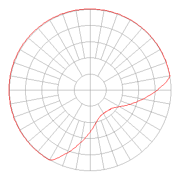 | ||||||||||||||||||
| Azimuth | Ratio | Azimuth | Ratio | Azimuth | Ratio | Azimuth | Ratio | ||||||||||||
| 0 | 1.000 | 10 | 1.000 | 20 | 1.000 | 30 | 1.000 | ||||||||||||
| 40 | 1.000 | 45 | 1.000 | 50 | 1.000 | 60 | 1.000 | ||||||||||||
| 70 | 1.000 | 80 | 1.000 | 90 | 0.832 | 100 | 0.661 | ||||||||||||
| 110 | 0.525 | 120 | 0.417 | 130 | 0.355 | 135 | 0.346 | ||||||||||||
| 140 | 0.336 | 150 | 0.336 | 160 | 0.355 | 170 | 0.417 | ||||||||||||
| 180 | 0.525 | 190 | 0.661 | 200 | 0.832 | 210 | 1.000 | ||||||||||||
| 220 | 1.000 | 225 | 1.000 | 230 | 1.000 | 240 | 1.000 | ||||||||||||
| 250 | 1.000 | 260 | 1.000 | 270 | 1.000 | 280 | 1.000 | ||||||||||||
| 290 | 1.000 | 300 | 1.000 | 310 | 1.000 | 315 | 1.000 | ||||||||||||
| 320 | 1.000 | 330 | 1.000 | 340 | 1.000 | 350 | 1.000 | ||||||||||||
Structure Registration Number 1002824 [ASR Heights Differ from WLPF Application] Structure Type: GTOWER Registered To: American Towers LLC Structure Address: Us129 & Ga158 (#205000) Ocilla, GA County Name: Berrien County ASR Issued: 08/03/2020 Date Built: 01/01/1992 Site Elevation: 96.6 m (317 ft.) Structure Height: 151.2 m (496 ft.) Height Overall: 151.4 m (497 ft.) Overall Height AMSL: 248 m (814 ft.) FAA Determination: 07/28/2020 FAA Study #: 2020-ASO-21876-OE FAA Circular #: 70/7460-1L Paint & Light FAA Chapters: 4, 8, 12 31-28-11.5 N 83-14-12.3 W (NAD 83) 31-28-10.8 N 83-14-12.7 W (Converted to NAD 27) |
2278 Wortham Lane Grovetown, GA 30813 Phone: 706-309-9610 Not-for-Profit | Date: 02/25/2009 Application Certifier AUGUSTA RADIO FELLOWSHIP INSTITUTE, INC. 2278 Wortham Lane Grovetown, GA 30813-5103 Applicant JEFFREY D. SOUTHMAYD Southmayd & Miller JEFFREY D SOUTHMAYD Southmayd & Miller 4 Ocean Ridge Boulevard South Palm Coast, FL 32137 ATTORNEY | |||||||||||||||||