
FCCInfo.com
A Service of Cavell, Mertz & Associates, Inc.
(855) FCC-INFO
|
|
K240DX from 08/22/1996 |
|
|
||||||||||||||||
|
|
K240DX Channel: 240D 95.9 MHz Eureka, California Service: FX - A translator or application for a translator. Facility ID: 79122 Fac. Service: FX Programming Delivery Method: Unspecified Status: License Application Accepted: 04/07/2015 Application Granted: 04/27/2015 File Number: BLFT-20150407ABB License Expires: 00/00/0000 Prefix Type: This is a license for a translator Application Type: License To Cover FCC Website Links: LMS Facility Details This Application CDBS Application Other K240DX Applications Other K240DX Applications in CDBS Including Superseded Applications Mailing Address Correspondence for K240DX Correspondence related to application BLFT-20150407ABB Service Contour - Open Street Map or USGS Map (60 dBu) Service Contour - KML / Google Earth (60 dBu) Class: D, A Noncommercial educational operating with no more than 10W Site Location: 40-49-31.5 N 124-00-09.2 W (NAD 83) Site Location: 40-49-32.0 N 124-00-05.0 W (Converted to NAD 27) Effective Radiated Power: 0 kW Horiz. ; 0.2 kW Vert. Transmitter Output Power: 0.055 kW Antenna Center HAAT: 0 m Antenna Center AMSL: 0 m Horiz.; 560 m Vert. Antenna Center HAG: 0 m Horiz.; 27 m Vert. Site Elevation: 533 m. (1749 ft.) Height Overall*: 52 m (171 ft.) (* As Filed In This Application, may differ from ASR Data, Below.) Directional Antenna Antenna Make/Model: None Antenna ID: 119264 Polarization:
| ||||||||||||||||||
| Antenna Data for Antenna Id: 119264 K240DX FX File: BLFT-20150407ABB None - Service: FX Pattern and Field Values Include a 280° Clockwise Rotation | 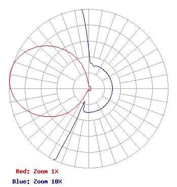 | ||||||||||||||||||
| Azimuth | Ratio | Azimuth | Ratio | Azimuth | Ratio | Azimuth | Ratio | ||||||||||||
| 0 | 0.050 | 10 | 0.030 | 20 | 0.030 | 30 | 0.030 | ||||||||||||
| 40 | 0.030 | 50 | 0.030 | 60 | 0.030 | 70 | 0.030 | ||||||||||||
| 80 | 0.030 | 90 | 0.030 | 100 | 0.030 | 110 | 0.030 | ||||||||||||
| 120 | 0.030 | 130 | 0.030 | 140 | 0.030 | 150 | 0.030 | ||||||||||||
| 160 | 0.030 | 170 | 0.030 | 180 | 0.030 | 190 | 0.030 | ||||||||||||
| 200 | 0.030 | 210 | 0.190 | 220 | 0.390 | 230 | 0.544 | ||||||||||||
| 240 | 0.690 | 250 | 0.817 | 260 | 0.916 | 270 | 0.980 | ||||||||||||
| 280 | 1.000 | 290 | 0.980 | 300 | 0.916 | 310 | 0.817 | ||||||||||||
| 320 | 0.690 | 330 | 0.544 | 340 | 0.390 | 350 | 0.190 | ||||||||||||
Structure Registration Number 1232199 Structure Type: Registered To: PWM, Inc. Structure Address: 6540 Fickle Hill Road Arcata, CA County Name: Humboldt County ASR Issued: 08/04/2021 Date Built: 01/01/1977 Site Elevation: 533.4 m (1750 ft.) Structure Height: 51.8 m (170 ft.) Height Overall: 51.8 m (170 ft.) Overall Height AMSL: 585.2 m (1920 ft.) FAA Determination: 03/29/2001 FAA Study #: 01-AWP-0971-OE Paint & Light FAA Chapters: NONE 40-49-31.4 N 124-00-09.2 W (NAD 83) 40-49-31.9 N 124-00-05.0 W (Converted to NAD 27) |
5700 West Oaks Blvd Rocklin, CA 95765 Phone: 916-251-1600 | Date: 04/07/2015 Application Certifier EDUCATIONAL MEDIA FOUNDATION 5700 West Oaks Blvd Rocklin, CA 95765 Applicant STEPHEN WILDE 5700 West Oaks Blvd Rocklin, CA 95765 BROADCAST ENGINEER MARY N. O'CONNOR Wilkinson Barker Knauer, Llp 2300 N Street, N.w. Suite 700 Washington, DC 20037-1128 | |||||||||||||||||