
FCCInfo.com
A Service of Cavell, Mertz & Associates, Inc.
(855) FCC-INFO
|
|
|
|
|
|||||||||||||||||||
|
|
WZZO Channel: 236B 95.1 MHz Bethlehem, Pennsylvania Service: FM - A full-service FM station or application. Facility ID: 14375 Fac. Service: FM Analog & Digital Status: License Application Accepted: 10/25/2011 Application Granted: 11/08/2011 File Number: BMLH-20111025AGT License Expires: 00/00/0000 Prefix Type: This is a modification of a license for a commecial FM station Application Type: Minor Modification FCC Website Links: LMS Facility Details This Application CDBS Application Other WZZO Applications Other WZZO Applications in CDBS Including Superseded Applications Mailing Address Correspondence for WZZO Correspondence related to application BMLH-20111025AGT Service Contour - Open Street Map or USGS Map (54 dBu) Service Contour - KML / Google Earth (54 dBu) Public Inspection Files History Cards for WZZO Facility Type: FM STATION Class: B, A Zone I or I-A station; with 25kW-50kW ERP and a class contour distance 39km-52km Site Location: 40-37-13.4 N 75-17-35.6 W (NAD 83) Site Location: 40-37-13.0 N 75-17-37.0 W (Converted to NAD 27) Effective Radiated Power: 30 kW Transmitter Output Power: 13.53 kW Antenna Center HAAT: 192 m (630 ft.) Antenna Center AMSL: 321 m (1053 ft.) Antenna Center HAG: 73 m (240 ft.) Calculated Site Elevation: 248 m. (814 ft.) Height Overall*: 77 m (253 ft.) (* As Filed In This Application, may differ from ASR Data, Below.) Directional Antenna Antenna Make/Model: Shivley 6810-3R-DA Antenna ID: 13994 Polarization: | |||||||||||||||||||||
| Antenna Data for Antenna Id: 13994 WZZO FM File: BMLH-20111025AGT Shivley - 6810-3R-DA Service: FM | 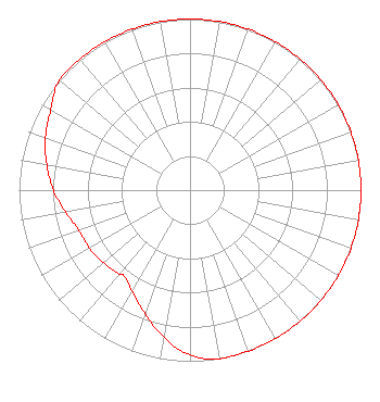 | |||||||||||||||||||||
| Azimuth | Ratio | Azimuth | Ratio | Azimuth | Ratio | Azimuth | Ratio | |||||||||||||||
| 0 | 1.000 | 10 | 1.000 | 20 | 1.000 | 30 | 1.000 | |||||||||||||||
| 40 | 1.000 | 50 | 1.000 | 60 | 1.000 | 70 | 1.000 | |||||||||||||||
| 80 | 1.000 | 90 | 1.000 | 100 | 1.000 | 110 | 1.000 | |||||||||||||||
| 120 | 1.000 | 130 | 1.000 | 140 | 1.000 | 150 | 1.000 | |||||||||||||||
| 160 | 1.000 | 170 | 1.000 | 180 | 0.965 | 190 | 0.875 | |||||||||||||||
| 200 | 0.770 | 210 | 0.680 | 218 | 0.632 | 220 | 0.640 | |||||||||||||||
| 230 | 0.660 | 240 | 0.680 | 250 | 0.690 | 260 | 0.740 | |||||||||||||||
| 270 | 0.800 | 280 | 0.850 | 290 | 0.900 | 300 | 0.940 | |||||||||||||||
| 310 | 1.000 | 320 | 1.000 | 330 | 1.000 | 340 | 1.000 | |||||||||||||||
| 350 | 1.000 | |||||||||||||||||||||
Structure Registration Number 1025306 [ASR Heights Differ from WZZO Application] Structure Type: TOWER Registered To: ADAMS, CHARLES F: WALTERS, WILLIAM D DBA ADAMS & WALTERS Structure Address: 4105 Sherry Hill Rd Lower Saucon Twp, PA County Name: Northampton County ASR Issued: 12/27/2017 Date Built: 01/01/1946 Site Elevation: 248 m (814 ft.) Structure Height: 76 m (249 ft.) Height Overall: 76 m (249 ft.) Overall Height AMSL: 324 m (1063 ft.) Paint & Light FAA Chapters: 1, 3, 12, 21 40-37-13.0 N 75-17-36.0 W (NAD 83) 40-37-12.6 N 75-17-37.4 W (Converted to NAD 27) |
7136 S. Yale Avenue Suite 501 Tulsa, OK 74136 Phone: 918-664-4581 | Date: 10/25/2011 Application Certifier CAPSTAR TX LLC 2625 S. Memorial Drive, Suite A Tulsa, OK 74129 Applicant CAPSTAR TX LLC Capstar Tx Llc STEVEN M. SLOCUM 2625 S Memorial Dr, Suite A Tulsa, OK 74129 STAFF ENGINEER | ||||||||||||||||||||
|
| |||||||||||||||||||||