
FCCInfo.com
A Service of Cavell, Mertz & Associates, Inc.
(855) FCC-INFO
|
|
K281CS from 11/22/2013 |
|
|
||||||||||||||||
|
|
K281CS Channel: 281D 104.1 MHz Mckinney, Texas Service: FX - A translator or application for a translator. Facility ID: 156828 Fac. Service: FX Programming Delivery Method: Unspecified Status: License Application Accepted: 04/19/2017 Application Granted: 04/28/2017 File Number: BLFT-20170419AHV License Expires: 00/00/0000 Prefix Type: This is a license for a translator Application Type: License To Cover FCC Website Links: LMS Facility Details This Application CDBS Application Other K281CS Applications Other K281CS Applications in CDBS Including Superseded Applications Mailing Address Correspondence for K281CS Correspondence related to application BLFT-20170419AHV Service Contour - Open Street Map or USGS Map (60 dBu) Service Contour - KML / Google Earth (60 dBu) Class: D, A Noncommercial educational operating with no more than 10W Site Location: 33-03-50.4 N 96-35-03.0 W (NAD 83) Site Location: 33-03-50.0 N 96-35-02.0 W (Converted to NAD 27) Effective Radiated Power: 0.25 kW Transmitter Output Power: 0.11 kW Antenna Center HAAT: 0 m Antenna Center AMSL: 285 m (935 ft.) Antenna Center HAG: 110 m (361 ft.) Site Elevation: 175 m. (574 ft.) Height Overall*: 145 m (476 ft.) (* As Filed In This Application, may differ from ASR Data, Below.) Directional Antenna Antenna Make/Model: None Antenna ID: 125307 Polarization:
| ||||||||||||||||||
| Antenna Data for Antenna Id: 125307 K281CS FX File: BLFT-20170419AHV None - Service: FX Pattern and Field Values Include a 270° Clockwise Rotation | 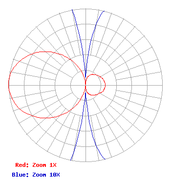 | ||||||||||||||||||
| Azimuth | Ratio | Azimuth | Ratio | Azimuth | Ratio | Azimuth | Ratio | ||||||||||||
| 0 | 0.010 | 10 | 0.080 | 20 | 0.130 | 30 | 0.160 | ||||||||||||
| 40 | 0.180 | 50 | 0.200 | 60 | 0.220 | 70 | 0.240 | ||||||||||||
| 80 | 0.250 | 90 | 0.260 | 100 | 0.250 | 110 | 0.240 | ||||||||||||
| 120 | 0.210 | 130 | 0.190 | 140 | 0.170 | 150 | 0.150 | ||||||||||||
| 160 | 0.120 | 170 | 0.080 | 180 | 0.010 | 190 | 0.090 | ||||||||||||
| 200 | 0.220 | 210 | 0.370 | 220 | 0.520 | 230 | 0.670 | ||||||||||||
| 240 | 0.800 | 250 | 0.910 | 260 | 0.970 | 270 | 1.000 | ||||||||||||
| 280 | 0.980 | 290 | 0.910 | 300 | 0.810 | 310 | 0.680 | ||||||||||||
| 320 | 0.530 | 330 | 0.380 | 340 | 0.230 | 350 | 0.100 | ||||||||||||
Structure Registration Number 1047140 [ASR Heights Differ from K281CS Application] Structure Type: GTOWER Registered To: American Towers LLC Structure Address: 1655 Stinson Road (lucas #90316) Allen, TX County Name: Collin County ASR Issued: 10/25/2022 Date Built: 10/04/2007 Site Elevation: 175.3 m (575 ft.) Structure Height: 138.4 m (454 ft.) Height Overall: 144.5 m (474 ft.) Overall Height AMSL: 319.8 m (1049 ft.) FAA Determination: 10/17/2022 FAA Study #: 2021-ASW-18151-OE FAA Circular #: 70/7460-1K Paint & Light FAA Chapters: 4, 8, 12 PRIOR STUDY 2008-ASW-6811-OE 33-03-50.4 N 96-35-03.0 W (NAD 83) 33-03-50.0 N 96-35-02.0 W (Converted to NAD 27) |
3304 Essex Dr. Richardson, TX 75082 Phone: 248-219-8851 Limited Liability Company | Date: 04/19/2017 Application Certifier HAMMOND BROADCASTING, LLC 6545 Crown Forest Dr. Plano, TX 75024 Applicant JOHN HAMMOND 6545 Crown Forest Dr. Plano, TX 75024 PRESIDENT DAN J. ALPERT The Law Office Of Dan J. Alpert 2120 N. 21st Rd. Arlington, VA 22201 | |||||||||||||||||