
FCCInfo.com
A Service of Cavell, Mertz & Associates, Inc.
(855) FCC-INFO
|
|
W245BK from 04/14/1997 |
|
|
||||||||||||||||
|
|
W245BK Channel: 245D 96.9 MHz Amherst, Massachusetts Service: FX - A translator or application for a translator. Facility ID: 84114 Fac. Service: FX Programming Delivery Method: Unspecified Status: License Application Accepted: 10/03/2014 Application Granted: 10/29/2014 File Number: BLFT-20141003AAT License Expires: 00/00/0000 Prefix Type: This is a license for a translator Application Type: License To Cover FCC Website Links: LMS Facility Details This Application CDBS Application Other W245BK Applications Other W245BK Applications in CDBS Including Superseded Applications Mailing Address Correspondence for W245BK Correspondence related to application BLFT-20141003AAT Service Contour - Open Street Map or USGS Map (60 dBu) Service Contour - KML / Google Earth (60 dBu) Class: D, A Noncommercial educational operating with no more than 10W Site Location: 42-22-25.3 N 72-40-24.3 W (NAD 83) Site Location: 42-22-25.0 N 72-40-26.0 W (Converted to NAD 27) Effective Radiated Power: 0.25 kW Transmitter Output Power: 0.65 kW Antenna Center HAAT: 0 m Antenna Center AMSL: 249 m (817 ft.) Antenna Center HAG: 59 m (194 ft.) Site Elevation: 190 m. (623 ft.) Height Overall*: 84 m (276 ft.) (* As Filed In This Application, may differ from ASR Data, Below.) Directional Antenna Antenna Make/Model: None Antenna ID: 119194 Polarization:
| ||||||||||||||||||
| Antenna Data for Antenna Id: 119194 W245BK FX File: BLFT-20141003AAT None - Service: FX | 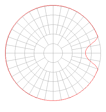 | ||||||||||||||||||
| Azimuth | Ratio | Azimuth | Ratio | Azimuth | Ratio | Azimuth | Ratio | ||||||||||||
| 0 | 1.000 | 10 | 1.000 | 20 | 1.000 | 30 | 1.000 | ||||||||||||
| 40 | 1.000 | 50 | 1.000 | 60 | 1.000 | 70 | 1.000 | ||||||||||||
| 80 | 0.750 | 90 | 0.680 | 100 | 0.750 | 110 | 1.000 | ||||||||||||
| 120 | 1.000 | 130 | 1.000 | 140 | 1.000 | 150 | 1.000 | ||||||||||||
| 160 | 1.000 | 170 | 1.000 | 180 | 1.000 | 190 | 1.000 | ||||||||||||
| 200 | 1.000 | 210 | 1.000 | 220 | 1.000 | 230 | 1.000 | ||||||||||||
| 240 | 1.000 | 250 | 1.000 | 260 | 1.000 | 270 | 1.000 | ||||||||||||
| 280 | 1.000 | 290 | 1.000 | 300 | 1.000 | 310 | 1.000 | ||||||||||||
| 320 | 1.000 | 330 | 1.000 | 340 | 1.000 | 350 | 1.000 | ||||||||||||
Structure Registration Number 1008868 Structure Type: TOWER Registered To: Saga Communications of New England, LLC Structure Address: On Horse Mountain 6 Km Nw Of Northampton Ma Williamsburg, MA County Name: Hampshire County ASR Issued: 04/27/2005 Date Built: 01/01/1993 Site Elevation: 189.9 m (623 ft.) Structure Height: 82.3 m (270 ft.) Height Overall: 83.8 m (275 ft.) Overall Height AMSL: 273.7 m (898 ft.) FAA Determination: 06/04/1997 FAA Study #: 97-ANE-0202-OE FAA Circular #: 70/7460-1H Paint & Light FAA Chapters: 3, 4, 5, 13 Removed expiration date from determination. Scenario 1./jjs/case#635066 42-22-25.0 N 72-40-24.0 W (NAD 83) 42-22-24.7 N 72-40-25.7 W (Converted to NAD 27) |
73 Kercheval Avenue Grosse Pointe Farms, MI 48236 Phone: 313-886-7070 | Date: 10/03/2014 Application Certifier SAGA COMMUNICATIONS OF NEW ENGLAND, LLC 73 Kercheval Avenue Grosse Pointe Farms, MI 48236 Applicant JUSTIN W. ASHER Munn-reese, Inc. Po Box 220, 385 Airport Drive Coldwater, MI 49036-0220 CONSULTING ENGINEER GARY S. SMITHWICK, ESQ. Smithwick & Belendiuk, P.c. 5028 Wisconsin Avenue, Nw Suite 301 Washington, DC 20016 | |||||||||||||||||