
FCCInfo.com
A Service of Cavell, Mertz & Associates, Inc.
(855) FCC-INFO
|
|
|
|
|
||||||||||||||||
|
|
WSRI Channel: 204A 88.7 MHz Sugar Grove, Illinois Service: FM - A full-service FM station or application. Facility ID: 93787 Fac. Service: FM Status: License Application Accepted: 04/10/2008 Application Granted: 06/17/2008 File Number: BLED-20080410ABW License Expires: 00/00/0000 Prefix Type: This is a license for a noncommercial educational FM station Application Type: Amendment FCC Website Links: LMS Facility Details This Application CDBS Application Other WSRI Applications Other WSRI Applications in CDBS Including Superseded Applications Mailing Address Correspondence for WSRI Correspondence related to application BLED-20080410ABW Service Contour - Open Street Map or USGS Map (60 dBu) Service Contour - KML / Google Earth (60 dBu) Public Inspection Files Facility Type: NON-COMMERCIAL EDUC. FM Class: A, A Zone I; I-A; or II station; with 0.1kW-6kW ERP and a class contour distance <=28km Site Location: 41-42-16.1 N 88-26-02.3 W (NAD 83) Site Location: 41-42-16.0 N 88-26-02.0 W (Converted to NAD 27) Effective Radiated Power: 0.6 kW Transmitter Output Power: 0.517 kW Antenna Center HAAT: 103 m (338 ft.) Antenna Center AMSL: 306 m (1004 ft.) Antenna Center HAG: 105 m (344 ft.) Site Elevation: 201 m. (659 ft.) Height Overall*: 122 m (400 ft.) (* As Filed In This Application, may differ from ASR Data, Below.) Directional Antenna Antenna Make/Model: Electronics Research Inc. LP-2E-DA-HW, 2 sections, 0.5 wavelength spacing Antenna ID: 76581 Polarization:
| ||||||||||||||||||
| Antenna Data for Antenna Id: 76581 WSRI FM File: BLED-20080410ABW Electronics Research Inc. - LP-2E-DA-HW, 2 sections, 0.5 wavelength spacing Service: FM | 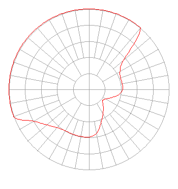 | ||||||||||||||||||
| Azimuth | Ratio | Azimuth | Ratio | Azimuth | Ratio | Azimuth | Ratio | ||||||||||||
| 0 | 1.000 | 10 | 1.000 | 20 | 1.000 | 30 | 1.000 | ||||||||||||
| 40 | 1.000 | 50 | 0.564 | 60 | 0.448 | 70 | 0.420 | ||||||||||||
| 80 | 0.420 | 90 | 0.420 | 100 | 0.377 | 110 | 0.299 | ||||||||||||
| 120 | 0.238 | 130 | 0.220 | 140 | 0.277 | 150 | 0.349 | ||||||||||||
| 160 | 0.439 | 170 | 0.553 | 180 | 0.593 | 190 | 0.593 | ||||||||||||
| 200 | 0.593 | 210 | 0.593 | 220 | 0.620 | 230 | 0.685 | ||||||||||||
| 240 | 0.794 | 250 | 1.000 | 260 | 1.000 | 270 | 1.000 | ||||||||||||
| 280 | 1.000 | 290 | 1.000 | 300 | 1.000 | 310 | 1.000 | ||||||||||||
| 320 | 1.000 | 330 | 1.000 | 340 | 1.000 | 350 | 1.000 | ||||||||||||
Structure Registration Number 1058390 Structure Type: GTOWER Registered To: Subcarrier Communications Inc Structure Address: 9274 Galena Blvd. Bristol, IL County Name: Kendall County ASR Issued: 12/21/2022 Date Built: 08/01/1999 Site Elevation: 200.6 m (658 ft.) Structure Height: 115.8 m (380 ft.) Height Overall: 121.9 m (400 ft.) Overall Height AMSL: 322.5 m (1058 ft.) FAA Determination: 11/23/1998 FAA Study #: 98-AGL-1515-OE FAA Circular #: 70/7460-1J Paint & Light FAA Chapters: 4, 6, 13 Removed expiration and final dates from determination. Scenario 2./jjs/case#635066 41-42-15.8 N 88-26-02.0 W (NAD 83) 41-42-15.7 N 88-26-01.7 W (Converted to NAD 27) |
5700 West Oaks Blvd Rocklin, CA 95765 Phone: 916-251-1600 Not-for-Profit | Date: 04/10/2008 Application Certifier EDUCATIONAL MEDIA FOUNDATION 5700 West Oaks Blvd Rocklin, CA 95765 Applicant SAM WALLINGTON 5700 West Oaks Blvd Rocklin, CA 95765 VP OF ENGINEERING DAVID D. OXENFORD, ESQ Davis Wright Tremaine Llp | |||||||||||||||||