
FCCInfo.com
A Service of Cavell, Mertz & Associates, Inc.
(855) FCC-INFO
|
|
|
|
|
||||||||||||||||
|
|
WYYD-FM1 Channel: 300D 107.9 MHz Roanoke, Virginia Service: FB - A booster station or application for a booster. Facility ID: 74283 Fac. Service: FB Programming Delivery Method: Unspecified Status: License Application Accepted: 10/07/2011 Application Granted: 12/18/2012 File Number: BLFTB-20111007ACD License Expires: 00/00/0000 Prefix Type: This is a license for a booster Application Type: License To Cover FCC Website Links: LMS Facility Details This Application CDBS Application Other WYYD-FM1 Applications Other WYYD-FM1 Applications in CDBS Including Superseded Applications Mailing Address Correspondence for WYYD-FM1 Correspondence related to application BLFTB-20111007ACD Service Contour - Open Street Map or USGS Map (60 dBu) Service Contour - KML / Google Earth (60 dBu) Facility Type: FM STATION Class: D, A Noncommercial educational operating with no more than 10W Site Location: 37-17-03.0 N 79-59-13.0 W (NAD 83) Site Location: 37-17-02.5 N 79-59-13.9 W (Converted to NAD 27) Effective Radiated Power: 2.5 kW Transmitter Output Power: 0.81 kW Antenna Center HAAT: 0 m Antenna Center AMSL: 384 m (1260 ft.) Antenna Center HAG: 70 m (230 ft.) Site Elevation: 314 m. (1030 ft.) Height Overall*: 117 m (384 ft.) (* As Filed In This Application, may differ from ASR Data, Below.) Directional Antenna Antenna Make/Model: None Antenna ID: 104255 Polarization:
| ||||||||||||||||||
| Antenna Data for Antenna Id: 104255 WYYD-FM1 FB File: BLFTB-20111007ACD None - Service: FB | 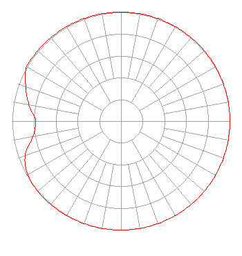 | ||||||||||||||||||
| Azimuth | Ratio | Azimuth | Ratio | Azimuth | Ratio | Azimuth | Ratio | ||||||||||||
| 0 | 1.000 | 10 | 1.000 | 20 | 1.000 | 30 | 1.000 | ||||||||||||
| 40 | 1.000 | 50 | 1.000 | 60 | 1.000 | 70 | 1.000 | ||||||||||||
| 80 | 1.000 | 90 | 1.000 | 100 | 1.000 | 110 | 1.000 | ||||||||||||
| 120 | 1.000 | 130 | 1.000 | 140 | 1.000 | 150 | 1.000 | ||||||||||||
| 160 | 1.000 | 170 | 1.000 | 180 | 1.000 | 190 | 1.000 | ||||||||||||
| 200 | 1.000 | 210 | 1.000 | 220 | 1.000 | 230 | 1.000 | ||||||||||||
| 240 | 0.989 | 250 | 0.937 | 260 | 0.822 | 270 | 0.783 | ||||||||||||
| 280 | 0.859 | 290 | 0.931 | 300 | 1.000 | 310 | 1.000 | ||||||||||||
| 320 | 1.000 | 330 | 1.000 | 340 | 1.000 | 350 | 1.000 | ||||||||||||
Structure Registration Number 1028277 Structure Type: TOWER Registered To: Vertical Bridge CC FM, LLC Structure Address: Shenandoah Road And Old Salem Road Roanoke, VA County Name: Roanoke city ASR Issued: 11/08/2018 Date Built: 10/20/1995 Site Elevation: 313.9 m (1030 ft.) Structure Height: 116.7 m (383 ft.) Height Overall: 117.4 m (385 ft.) Overall Height AMSL: 431.3 m (1415 ft.) FAA Determination: 07/29/1997 FAA Study #: 97-AEA-0774-OE FAA Circular #: 70/7460-1J Paint & Light FAA Chapters: 3, 4, 5, 13 37-17-03.0 N 79-59-13.0 W (NAD 83) 37-17-02.5 N 79-59-13.9 W (Converted to NAD 27) |
7136 S. Yale Avenue Suite 501 Tulsa, OK 74136 Phone: 918-664-4581 | Date: 10/07/2011 Application Certifier CAPSTAR TX LLC 2625 S. Memorial Drive, Suite A Tulsa, OK 74129 Applicant TROY G. LANGHAM 2625 S. Memorial Dr. Suite A Tulsa, OK 74129 FCC ENGINEERING SUPERVISOR CAPSTAR TX LLC Capstar Tx Llc 2625 S. Memorial Drive, Suite A Tulsa, OK 74129 | |||||||||||||||||