
FCCInfo.com
A Service of Cavell, Mertz & Associates, Inc.
(855) FCC-INFO
|
|
KPKL-FM1 from 09/05/2012 |
|
|
||||||||||||||||
|
|
KPKL-FM1 Channel: 296D 107.1 MHz Spokane, Washington Service: FB - A booster station or application for a booster. Facility ID: 190691 Fac. Service: FB Programming Delivery Method: Unspecified Status: License Application Accepted: 05/13/2019 Application Granted: 05/22/2019 File Number: BLFTB-20190513AAT License Expires: 00/00/0000 Prefix Type: This is a license for a booster Application Type: License To Cover FCC Website Links: LMS Facility Details This Application CDBS Application Other KPKL-FM1 Applications Other KPKL-FM1 Applications in CDBS Including Superseded Applications Mailing Address Correspondence for KPKL-FM1 Correspondence related to application BLFTB-20190513AAT Service Contour - Open Street Map or USGS Map (60 dBu) Service Contour - KML / Google Earth (60 dBu) Facility Type: FM STATION Class: D, A Noncommercial educational operating with no more than 10W Site Location: 47-41-51.6 N 117-31-10.8 W (NAD 83) Site Location: 47-41-52.0 N 117-31-07.0 W (Converted to NAD 27) Effective Radiated Power: 5 kW Transmitter Output Power: 0.55 kW Antenna Center HAAT: 0 m Antenna Center AMSL: 748 m (2454 ft.) Antenna Center HAG: 77 m (253 ft.) Site Elevation: 671 m. (2201 ft.) Height Overall*: 80 m (262 ft.) (* As Filed In This Application, may differ from ASR Data, Below.) Directional Antenna Antenna Make/Model: None Antenna ID: 126450 Polarization:
| ||||||||||||||||||
| Antenna Data for Antenna Id: 126450 KPKL-FM1 FB File: BLFTB-20190513AAT None - Service: FB Pattern and Field Values Include a 36° Clockwise Rotation | 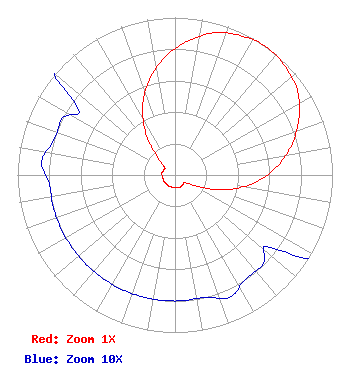 | ||||||||||||||||||
| Azimuth | Ratio | Azimuth | Ratio | Azimuth | Ratio | Azimuth | Ratio | ||||||||||||
| 6 | 0.860 | 16 | 0.940 | 26 | 0.980 | 36 | 1.000 | ||||||||||||
| 46 | 0.980 | 56 | 0.940 | 66 | 0.860 | 76 | 0.760 | ||||||||||||
| 86 | 0.640 | 96 | 0.500 | 106 | 0.340 | 116 | 0.170 | ||||||||||||
| 126 | 0.080 | 136 | 0.080 | 146 | 0.080 | 156 | 0.085 | ||||||||||||
| 166 | 0.080 | 176 | 0.080 | 186 | 0.080 | 196 | 0.080 | ||||||||||||
| 206 | 0.080 | 216 | 0.080 | 226 | 0.080 | 236 | 0.080 | ||||||||||||
| 246 | 0.080 | 256 | 0.080 | 266 | 0.080 | 276 | 0.085 | ||||||||||||
| 286 | 0.080 | 296 | 0.080 | 306 | 0.080 | 316 | 0.170 | ||||||||||||
| 326 | 0.340 | 336 | 0.500 | 346 | 0.640 | 356 | 0.760 | ||||||||||||
Structure Registration Number 1216657 Structure Type: Registered To: K2 Towers III, LLC Structure Address: 1.3 Km Nne Of Intersection Of Euclid And Dowdy Rd Airway Heights, WA County Name: Spokane County ASR Issued: 10/10/2022 Date Built: 01/01/1980 Site Elevation: 670.6 m (2200 ft.) Structure Height: 80.2 m (263 ft.) Height Overall: 80.2 m (263 ft.) Overall Height AMSL: 750.8 m (2463 ft.) FAA Determination: 08/04/2000 FAA Study #: 00-ANM-1139-OE FAA Circular #: 70/7460-1K Paint & Light FAA Chapters: 3, 4, 5, 12 Removed expiration date from determination. Scenario 1./jjs/case#635066 47-41-51.6 N 117-31-10.8 W (NAD 83) 47-41-52.0 N 117-31-07.0 W (Converted to NAD 27) |
Ewing Anderson P.s. 522 W. Riverside, Suite 800 Spokane, WA 99201-0519 Phone: 509-838-4261 | Date: 05/13/2019 Application Certifier SPOKANE BROADCASTING COMPANY LLC 400 South Jefferson St. Suite 304 Spokane, WA 99204 Applicant RANDY PUGSLEY 2669 Gloria Drive West Linn, OR 97068 CONSULTING ENGINEER BOB FOGAL Spokane Broadcasting Company Llc 400 South Jefferson St. Suite 304 Spokane, WA 99204 | |||||||||||||||||