
FCCInfo.com
A Service of Cavell, Mertz & Associates, Inc.
(855) FCC-INFO
|
|
|
|
|
||||||||||||||||
|
|
W241AO Channel: 241D 96.1 MHz Wye Mills, Maryland Service: FX - A translator or application for a translator. Facility ID: 154276 Fac. Service: FX Programming Delivery Method: Unspecified Status: License Application Accepted: 10/19/2015 Application Granted: 10/26/2015 File Number: BLFT-20151019AUB License Expires: 00/00/0000 Prefix Type: This is a license for a translator Application Type: License To Cover FCC Website Links: LMS Facility Details This Application CDBS Application Other W241AO Applications Other W241AO Applications in CDBS Including Superseded Applications Mailing Address Correspondence for W241AO Correspondence related to application BLFT-20151019AUB Service Contour - Open Street Map or USGS Map (60 dBu) Service Contour - KML / Google Earth (60 dBu) Class: D, A Noncommercial educational operating with no more than 10W Site Location: 39-06-47.4 N 76-00-56.8 W (NAD 83) Site Location: 39-06-47.0 N 76-00-58.0 W (Converted to NAD 27) Effective Radiated Power: 0.045 kW Transmitter Output Power: 0.018 kW Antenna Center HAAT: 85.9 m Horiz.; 0 m Vert. Antenna Center AMSL: 94 m (308 ft.) Antenna Center HAG: 80 m (262 ft.) Site Elevation: 14 m. (46 ft.) Height Overall*: 98 m (322 ft.) (* As Filed In This Application, may differ from ASR Data, Below.) Directional Antenna Antenna Make/Model: None Antenna ID: 16149 Polarization:
| ||||||||||||||||||
| Antenna Data for Antenna Id: 16149 W241AO FX File: BLFT-20151019AUB None - Service: FX Pattern and Field Values Include a 250° Clockwise Rotation | 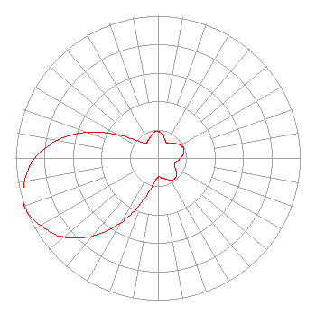 | ||||||||||||||||||
| Azimuth | Ratio | Azimuth | Ratio | Azimuth | Ratio | Azimuth | Ratio | ||||||||||||
| 0 | 0.187 | 10 | 0.171 | 20 | 0.140 | 30 | 0.123 | ||||||||||||
| 40 | 0.135 | 50 | 0.160 | 60 | 0.182 | 70 | 0.193 | ||||||||||||
| 80 | 0.182 | 90 | 0.160 | 100 | 0.135 | 110 | 0.123 | ||||||||||||
| 120 | 0.140 | 130 | 0.171 | 140 | 0.187 | 150 | 0.181 | ||||||||||||
| 160 | 0.157 | 170 | 0.142 | 180 | 0.134 | 190 | 0.190 | ||||||||||||
| 200 | 0.329 | 210 | 0.528 | 220 | 0.718 | 230 | 0.866 | ||||||||||||
| 240 | 0.952 | 250 | 1.000 | 260 | 0.952 | 270 | 0.866 | ||||||||||||
| 280 | 0.718 | 290 | 0.528 | 300 | 0.329 | 310 | 0.190 | ||||||||||||
| 320 | 0.134 | 330 | 0.142 | 340 | 0.157 | 350 | 0.181 | ||||||||||||
Structure Registration Number 1060047 [ASR Heights Differ from W241AO Application] Structure Type: TOWER Registered To: CTI Towers Assets II, LLC Structure Address: Rd. 213 1.5 Mi Sw Of Church Hill Starkey Corner, MD County Name: Queen Anne's County ASR Issued: 12/07/2022 Date Built: 10/26/1995 Site Elevation: 13.7 m (45 ft.) Structure Height: 91.4 m (300 ft.) Height Overall: 97.5 m (320 ft.) Overall Height AMSL: 111.2 m (365 ft.) FAA Determination: 05/20/1994 FAA Study #: 94-AEA-0605-OE FAA Circular #: 70/7460-1H Paint & Light FAA Chapters: 3, 4, 5, 13 39-06-47.0 N 76-00-57.0 W (NAD 83) 39-06-46.6 N 76-00-58.2 W (Converted to NAD 27) |
1308 Warren Avenue Williamsport, PA 17701 Phone: 570-327-1300 Limited Liability Company | Date: 10/19/2015 Application Certifier HOPE CHRISTIAN CHURCH OF MARLTON, INC. 55 East Main Street Marlton, NJ 08053 Applicant WILLIAM C. LUEBKEMANN, JR. 55 East Main Street Marlton, NJ 08053 PRESIDENT/CHIEF ENGINEER HARRY C. MARTIN, ESQUIRE Fletcher, Heald & Hildreth, Plc 1300 North 17th Street 11th Floor Arlington, VA 22209 | |||||||||||||||||