
FCCInfo.com
A Service of Cavell, Mertz & Associates, Inc.
(855) FCC-INFO
|
|
|
|
|
||||||||||||||||
|
|
W289BZ Channel: 289D 105.7 MHz Bristol, Tennessee Service: FX - A translator or application for a translator. Facility ID: 147709 Fac. Service: FX Programming Delivery Method: Unspecified Status: License Application Accepted: 04/23/2019 Application Granted: 05/01/2019 File Number: BLFT-20190423AAS License Expires: 00/00/0000 Prefix Type: This is a license for a translator Application Type: License To Cover FCC Website Links: LMS Facility Details This Application CDBS Application Other W289BZ Applications Other W289BZ Applications in CDBS Including Superseded Applications Mailing Address Correspondence for W289BZ Correspondence related to application BLFT-20190423AAS Service Contour - Open Street Map or USGS Map (60 dBu) Service Contour - KML / Google Earth (60 dBu) Class: D, A Noncommercial educational operating with no more than 10W Site Location: 36-25-53.4 N 82-08-15.5 W (NAD 83) Site Location: 36-25-53.0 N 82-08-16.0 W (Converted to NAD 27) Effective Radiated Power: 0 kW Horiz. ; 0.25 kW Vert. Transmitter Output Power: 0.244 kW Antenna Center HAAT: 0 m Antenna Center AMSL: 0 m Horiz.; 1298 m Vert. Antenna Center HAG: 0 m Horiz.; 26 m Vert. Site Elevation: 1272 m. (4173 ft.) Height Overall*: 69 m (226 ft.) (* As Filed In This Application, may differ from ASR Data, Below.) Directional Antenna Antenna Make/Model: None Antenna ID: 134661 Polarization:
| ||||||||||||||||||
| Antenna Data for Antenna Id: 134661 W289BZ FX File: BLFT-20190423AAS None - Service: FX | 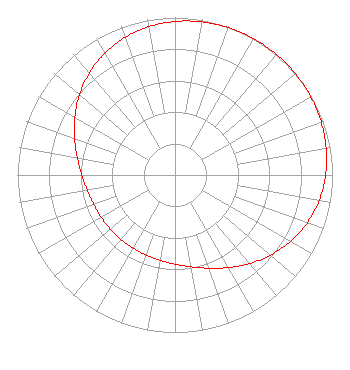 | ||||||||||||||||||
| Azimuth | Ratio | Azimuth | Ratio | Azimuth | Ratio | Azimuth | Ratio | ||||||||||||
| 0 | 0.975 | 10 | 0.987 | 20 | 0.995 | 30 | 0.999 | ||||||||||||
| 40 | 1.000 | 50 | 0.999 | 60 | 0.995 | 70 | 0.987 | ||||||||||||
| 80 | 0.975 | 90 | 0.956 | 100 | 0.929 | 110 | 0.892 | ||||||||||||
| 120 | 0.845 | 130 | 0.792 | 140 | 0.735 | 150 | 0.679 | ||||||||||||
| 160 | 0.630 | 170 | 0.592 | 180 | 0.566 | 190 | 0.549 | ||||||||||||
| 200 | 0.540 | 210 | 0.535 | 220 | 0.534 | 230 | 0.535 | ||||||||||||
| 240 | 0.540 | 250 | 0.549 | 260 | 0.566 | 270 | 0.592 | ||||||||||||
| 280 | 0.630 | 290 | 0.679 | 300 | 0.735 | 310 | 0.792 | ||||||||||||
| 320 | 0.845 | 330 | 0.892 | 340 | 0.929 | 350 | 0.956 | ||||||||||||
Structure Registration Number 1054538 Structure Type: TOWER Registered To: HOLSTON VALLEY BROADCASTING CORPORATION Structure Address: 6247 Panhandle Road Hunter, TN County Name: Carter County ASR Issued: 08/06/1998 Date Built: 10/01/1994 Site Elevation: 1271.9 m (4173 ft.) Structure Height: 51.6 m (169 ft.) Height Overall: 68.8 m (226 ft.) Overall Height AMSL: 1340.7 m (4399 ft.) FAA Determination: 07/14/1998 FAA Study #: 98-ASO-2328-OE FAA Circular #: 70/7460-1J Paint & Light FAA Chapters: 3, 4, 5, 13 36-25-53.0 N 82-08-15.0 W (NAD 83) 36-25-52.6 N 82-08-15.5 W (Converted to NAD 27) |
Po Box Wkpt Kingsport, TN 37662-1971 Phone: 423-246-9578 | Date: 04/23/2019 Application Certifier HOLSTON VALLEY BROADCASTING CORPORATION 222 Commerce Street Kingsport, TN 37660 Applicant DARRYL K. DELAWDER Delawder Communications, Inc. Post Office Box 1095 Ashburn, VA 20146-1095 ENGINEERING CONSULTANT DENNIS J. KELLY Law Office Of Dennis J. Kelly Post Office Box 41177 Washington, DC 20018-0577 | |||||||||||||||||