
FCCInfo.com
A Service of Cavell, Mertz & Associates, Inc.
(855) FCC-INFO
|
|
K207DQ from 10/29/1999 |
|
|
||||||||||||||||
|
|
K207DQ Channel: 207D 89.3 MHz Florence, Oregon Service: FX - A translator or application for a translator. Facility ID: 93077 Fac. Service: FX Programming Delivery Method: Unspecified Status: License Application Accepted: 05/28/2013 Application Granted: 06/12/2013 File Number: BLFT-20130528AEI License Expires: 00/00/0000 Prefix Type: This is a license for a translator Application Type: License To Cover FCC Website Links: LMS Facility Details This Application CDBS Application Other K207DQ Applications Other K207DQ Applications in CDBS Including Superseded Applications Mailing Address Correspondence for K207DQ Correspondence related to application BLFT-20130528AEI Service Contour - Open Street Map or USGS Map (60 dBu) Service Contour - KML / Google Earth (60 dBu) Class: D, A Noncommercial educational operating with no more than 10W Site Location: 43-57-19.4 N 124-04-30.4 W (NAD 83) Site Location: 43-57-20.0 N 124-04-26.0 W (Converted to NAD 27) Effective Radiated Power: 0 kW Horiz. ; 0.041 kW Vert. Transmitter Output Power: 0.027 kW Antenna Center HAAT: 164.9 m Horiz.; 0 m Vert. Antenna Center AMSL: 0 m Horiz.; 242 m Vert. Antenna Center HAG: 0 m Horiz.; 23 m Vert. Site Elevation: 219 m. (719 ft.) Height Overall*: 34 m (112 ft.) (* As Filed In This Application, may differ from ASR Data, Below.) Directional Antenna Antenna Make/Model: None Antenna ID: 16130 Polarization:
| ||||||||||||||||||
| Antenna Data for Antenna Id: 16130 K207DQ FX File: BLFT-20130528AEI None - Service: FX Pattern and Field Values Include a 320° Clockwise Rotation | 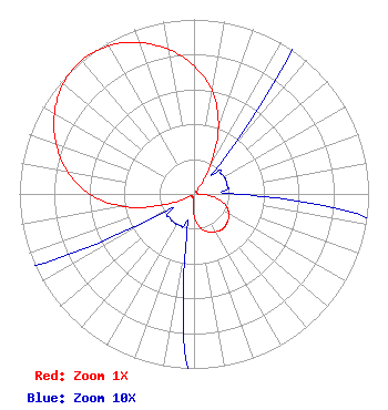 | ||||||||||||||||||
| Azimuth | Ratio | Azimuth | Ratio | Azimuth | Ratio | Azimuth | Ratio | ||||||||||||
| 0 | 0.735 | 10 | 0.600 | 20 | 0.410 | 30 | 0.185 | ||||||||||||
| 40 | 0.030 | 50 | 0.020 | 60 | 0.020 | 70 | 0.020 | ||||||||||||
| 80 | 0.020 | 90 | 0.025 | 100 | 0.125 | 110 | 0.195 | ||||||||||||
| 120 | 0.230 | 130 | 0.250 | 140 | 0.260 | 150 | 0.250 | ||||||||||||
| 160 | 0.230 | 170 | 0.195 | 180 | 0.125 | 190 | 0.025 | ||||||||||||
| 200 | 0.020 | 210 | 0.020 | 220 | 0.020 | 230 | 0.020 | ||||||||||||
| 240 | 0.030 | 250 | 0.185 | 260 | 0.410 | 270 | 0.600 | ||||||||||||
| 280 | 0.735 | 290 | 0.840 | 300 | 0.923 | 310 | 0.980 | ||||||||||||
| 320 | 1.000 | 330 | 0.980 | 340 | 0.923 | 350 | 0.840 | ||||||||||||
Structure Registration Number 1061293 [ASR Heights Differ from K207DQ Application] Structure Type: TOWER Registered To: VB-S1 Assets, LLC Structure Address: Top Of Glenada Hill Florence, OR County Name: Lane County ASR Issued: 08/24/2021 Date Built: 10/03/1990 Site Elevation: 219.4 m (720 ft.) Structure Height: 30.4 m (100 ft.) Height Overall: 33.5 m (110 ft.) Overall Height AMSL: 252.9 m (830 ft.) FAA Determination: 09/09/1996 FAA Study #: 90-ANM-0524-OE Paint & Light FAA Chapters: NONE 43-57-19.0 N 124-04-30.0 W (NAD 83) 43-57-19.6 N 124-04-25.6 W (Converted to NAD 27) |
P.o. Box 391 4002 N. 3300 E. Twin Falls, ID 83303 Phone: 208-733-3133 | Date: 05/28/2013 Application Certifier CALVARY CHAPEL OF TWIN FALLS, INC. Po Box 391 Twin Falls, ID 83303 Applicant LOIS MILLS Po Box 391 Twin Falls, ID 83303 APPLICATION TECHNICIAN CARY TEPPER Booth, Freret, Imlay And Tepper, Pc 7900 Wisconsin Ave, Suite 304 Bethesda, MD 20814-3628 | |||||||||||||||||