
FCCInfo.com
A Service of Cavell, Mertz & Associates, Inc.
(855) FCC-INFO
|
|
|
|
|
||||||||||||||||
|
|
KSLT-FM1 Channel: 296D 107.1 MHz Rapid City, South Dakota Service: FB - A booster station or application for a booster. Facility ID: 161668 Fac. Service: FB Programming Delivery Method: Unspecified Status: License Application Accepted: 10/26/2011 Application Granted: 11/03/2011 File Number: BLFTB-20111026AEZ License Expires: 00/00/0000 Prefix Type: This is a license for a booster Application Type: License To Cover FCC Website Links: LMS Facility Details This Application CDBS Application Other KSLT-FM1 Applications Other KSLT-FM1 Applications in CDBS Including Superseded Applications Mailing Address Correspondence for KSLT-FM1 Correspondence related to application BLFTB-20111026AEZ Service Contour - Open Street Map or USGS Map (60 dBu) Service Contour - KML / Google Earth (60 dBu) Facility Type: FM STATION Class: D, A Noncommercial educational operating with no more than 10W Site Location: 44-05-33.0 N 103-14-54.7 W (NAD 83) Site Location: 44-05-33.0 N 103-14-53.0 W (Converted to NAD 27) Effective Radiated Power: 2.4 kW Transmitter Output Power: 0.885 kW Antenna Center HAAT: 0 m Antenna Center AMSL: 1198 m (3930 ft.) Antenna Center HAG: 52 m (171 ft.) Site Elevation: 1146 m. (3760 ft.) Height Overall*: 163 m (535 ft.) (* As Filed In This Application, may differ from ASR Data, Below.) Directional Antenna Antenna Make/Model: None Antenna ID: 106761 Polarization:
| ||||||||||||||||||
| Antenna Data for Antenna Id: 106761 KSLT-FM1 FB File: BLFTB-20111026AEZ None - Service: FB | 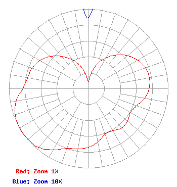 | ||||||||||||||||||
| Azimuth | Ratio | Azimuth | Ratio | Azimuth | Ratio | Azimuth | Ratio | ||||||||||||
| 0 | 0.089 | 10 | 0.183 | 20 | 0.329 | 30 | 0.442 | ||||||||||||
| 40 | 0.549 | 50 | 0.642 | 60 | 0.715 | 70 | 0.761 | ||||||||||||
| 80 | 0.776 | 90 | 0.761 | 100 | 0.715 | 110 | 0.642 | ||||||||||||
| 120 | 0.607 | 130 | 0.639 | 140 | 0.649 | 150 | 0.613 | ||||||||||||
| 160 | 0.611 | 170 | 0.682 | 180 | 0.741 | 190 | 0.771 | ||||||||||||
| 200 | 0.803 | 210 | 0.890 | 220 | 0.969 | 230 | 0.994 | ||||||||||||
| 235 | 1.000 | 240 | 0.998 | 250 | 0.978 | 260 | 0.923 | ||||||||||||
| 270 | 0.824 | 280 | 0.774 | 290 | 0.753 | 300 | 0.702 | ||||||||||||
| 310 | 0.624 | 320 | 0.528 | 330 | 0.419 | 340 | 0.303 | ||||||||||||
| 350 | 0.160 | ||||||||||||||||||
Structure Registration Number 1048502 Structure Type: TOWER Registered To: RAPID BROADCASTING DBA = KNBN TV Structure Address: Cowboy Hill Rapid City, SD County Name: Pennington County ASR Issued: 09/25/2000 Date Built: 10/05/2001 Site Elevation: 1146 m (3760 ft.) Structure Height: 146.6 m (481 ft.) Height Overall: 163.1 m (535 ft.) Overall Height AMSL: 1309.1 m (4295 ft.) FAA Determination: 08/15/2000 FAA Study #: 00-AGL-1087-OE FAA Circular #: 70/7460-1J Paint & Light FAA Chapters: 3, 4, 5, 13 Removed expiration and final dates from determination. Scenario 2./jjs/case#635066 44-05-33.0 N 103-14-55.0 W (NAD 83) 44-05-33.0 N 103-14-53.3 W (Converted to NAD 27) |
3003 Snelling Ave N Saint Paul, MN 55113 Phone: 651-631-5009 Not-for-Profit | Date: 10/26/2011 Application Certifier BETHESDA CHRISTIAN BROADCASTING 1723 Michigan Street Sturgeon Bay, WI 54235 Applicant JOSEPH G STANDISH 1853 Fountain Plaza Dr Rapid City, SD 57702 STATION ENGINEER J. DOMINIC MONAHAN Luvaas Cobb Suite 300 777 High Street Eugene, OR 97401-2787 | |||||||||||||||||