
FCCInfo.com
A Service of Cavell, Mertz & Associates, Inc.
(855) FCC-INFO
|
|
|
|
|
||||||||||||||||
|
|
K222AQ Channel: 222D 92.3 MHz Oroville, California Service: FX - A translator or application for a translator. Facility ID: 148348 Fac. Service: FX Programming Delivery Method: Unspecified Status: License Application Accepted: 09/13/2006 Application Granted: 10/12/2006 File Number: BLFT-20060913ACI License Expires: 00/00/0000 Prefix Type: This is a license for a translator Application Type: License To Cover FCC Website Links: LMS Facility Details This Application CDBS Application Other K222AQ Applications Other K222AQ Applications in CDBS Including Superseded Applications Mailing Address Correspondence for K222AQ Correspondence related to application BLFT-20060913ACI Service Contour - Open Street Map or USGS Map (60 dBu) Service Contour - KML / Google Earth (60 dBu) Class: D, A Noncommercial educational operating with no more than 10W Site Location: 39-27-46.0 N 121-34-53.0 W (NAD 83) Site Location: 39-27-46.4 N 121-34-49.1 W (Converted to NAD 27) Effective Radiated Power: 0.25 kW Transmitter Output Power: 0.091 kW Antenna Center HAAT: -12.2 m Horiz.; 0 m Vert. Antenna Center AMSL: 87 m (285 ft.) Antenna Center HAG: 15 m (49 ft.) Site Elevation: 72 m. (236 ft.) Height Overall*: 30 m (98 ft.) (* As Filed In This Application, may differ from ASR Data, Below.) Directional Antenna Antenna Make/Model: None Antenna ID: 65985 Polarization:
| ||||||||||||||||||
| Antenna Data for Antenna Id: 65985 K222AQ FX File: BLFT-20060913ACI None - Service: FX Pattern and Field Values Include a 34° Clockwise Rotation | 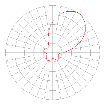 | ||||||||||||||||||
| Azimuth | Ratio | Azimuth | Ratio | Azimuth | Ratio | Azimuth | Ratio | ||||||||||||
| 4 | 0.718 | 14 | 0.866 | 24 | 0.952 | 34 | 1.000 | ||||||||||||
| 44 | 0.952 | 54 | 0.866 | 64 | 0.718 | 74 | 0.528 | ||||||||||||
| 84 | 0.329 | 94 | 0.190 | 104 | 0.134 | 114 | 0.142 | ||||||||||||
| 124 | 0.157 | 134 | 0.181 | 144 | 0.187 | 154 | 0.171 | ||||||||||||
| 164 | 0.140 | 174 | 0.123 | 184 | 0.135 | 194 | 0.160 | ||||||||||||
| 204 | 0.182 | 214 | 0.193 | 224 | 0.182 | 234 | 0.160 | ||||||||||||
| 244 | 0.135 | 254 | 0.123 | 264 | 0.140 | 274 | 0.171 | ||||||||||||
| 284 | 0.187 | 294 | 0.181 | 304 | 0.157 | 314 | 0.142 | ||||||||||||
| 324 | 0.134 | 334 | 0.190 | 344 | 0.329 | 354 | 0.528 | ||||||||||||
Structure Registration Number 1063515 Structure Type: TOWER Registered To: Sinclair Television of California, LLC Structure Address: Hwy 70 Approx 5 Km Sw Oroville, CA County Name: Butte County ASR Issued: 03/05/2024 Date Built: 08/01/1999 Site Elevation: 72.5 m (238 ft.) Structure Height: 30.5 m (100 ft.) Height Overall: 30.5 m (100 ft.) Overall Height AMSL: 103 m (338 ft.) FAA Determination: 04/02/1999 FAA Study #: 99-AWP-0302-OE Paint & Light FAA Chapters: NONE 39-27-46.0 N 121-34-53.0 W (NAD 83) 39-27-46.4 N 121-34-49.1 W (Converted to NAD 27) |
North State Public Radio 35 Main Street, Suite 101 Chico, CA 95928 Phone: 530-898-6100 | Date: 09/13/2006 Application Certifier THE RESEARCH FOUNDATION California State University Chico, CA 95929-0500 Applicant MICHAEL R. BIRDSILL Kcho Radio California State University Chico, CA 95929-0500 CHIEF ENGINEER JEROLD L. JACOBS, ESQ. Cohn And Marks Llp 1920 N Street, N.w. Suite 300 Washington, DC 20036-1622 | |||||||||||||||||