
FCCInfo.com
A Service of Cavell, Mertz & Associates, Inc.
(855) FCC-INFO
|
|
KCJH from 08/15/1999 |
|  |
|
|||||||||||||||
|
|
KCJH Channel: 206B1 89.1 MHz Livingston, California Service: FM - A full-service FM station or application. Facility ID: 63466 Fac. Service: FM Status: License Application Accepted: 06/28/2019 Application Granted: 08/26/2019 File Number: BLED-20190628AAS License Expires: 00/00/0000 Prefix Type: This is a license for a noncommercial educational FM station Application Type: Amendment FCC Website Links: LMS Facility Details This Application CDBS Application Other KCJH Applications Other KCJH Applications in CDBS Including Superseded Applications Mailing Address Correspondence for KCJH Correspondence related to application BLED-20190628AAS Service Contour - Open Street Map or USGS Map (60 dBu) Service Contour - KML / Google Earth (60 dBu) Public Inspection Files Facility Type: NON-COMMERCIAL EDUC. FM Class: B1, A Zone I or I-A station; with 6kW-25kW ERP and a class contour distance 28km-39km Site Location: 37-34-45.8 N 120-50-51.7 W (NAD 83) Site Location: 37-34-46.0 N 120-50-48.0 W (Converted to NAD 27) Effective Radiated Power: 0 kW Horiz. ; 13 kW Vert. Transmitter Output Power: 2.483 kW Antenna Center HAAT: 0 m Horiz.; 95 m Vert. Antenna Center AMSL: 0 m Horiz.; 129 m Vert. Antenna Center HAG: 0 m Horiz.; 92 m Vert. Site Elevation: 37 m. (121 ft.) Height Overall*: 123 m (404 ft.) (* As Filed In This Application, may differ from ASR Data, Below.) Directional Antenna Antenna Make/Model: Propagation System Inc PSIFMV-3E-DA, 3 bays, 1 wavelength, V only Antenna ID: 133705 Polarization: | ||||||||||||||||||
| Antenna Data for Antenna Id: 133705 KCJH FM File: BLED-20190628AAS Propagation System Inc - PSIFMV-3E-DA, 3 bays, 1 wavelength, V only Service: FM | 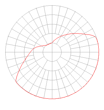 | ||||||||||||||||||
| Azimuth | Ratio | Azimuth | Ratio | Azimuth | Ratio | Azimuth | Ratio | ||||||||||||
| 0 | 0.198 | 10 | 0.248 | 20 | 0.311 | 30 | 0.390 | ||||||||||||
| 40 | 0.489 | 50 | 0.614 | 60 | 0.771 | 70 | 0.968 | ||||||||||||
| 80 | 1.000 | 90 | 1.000 | 100 | 1.000 | 110 | 1.000 | ||||||||||||
| 120 | 1.000 | 130 | 1.000 | 140 | 1.000 | 150 | 1.000 | ||||||||||||
| 160 | 1.000 | 170 | 1.000 | 180 | 1.000 | 190 | 1.000 | ||||||||||||
| 200 | 1.000 | 210 | 1.000 | 220 | 1.000 | 230 | 1.000 | ||||||||||||
| 240 | 0.818 | 250 | 0.652 | 260 | 0.534 | 270 | 0.458 | ||||||||||||
| 280 | 0.403 | 290 | 0.326 | 300 | 0.260 | 310 | 0.215 | ||||||||||||
| 320 | 0.189 | 330 | 0.182 | 340 | 0.180 | 350 | 0.187 | ||||||||||||
Structure Registration Number 1015786 Structure Type: TOWER Registered To: GOLDEN PEGASUS FINANCIAL SERVICES, INC. Structure Address: 4043 Geer Rd Hughson, CA County Name: Stanislaus County ASR Issued: 03/20/1999 Date Built: 02/28/1987 Site Elevation: 36.6 m (120 ft.) Structure Height: 121.9 m (400 ft.) Height Overall: 122.8 m (403 ft.) Overall Height AMSL: 159.4 m (523 ft.) FAA Study #: N/A Paint & Light FAA Chapters: 1, 3, 12, 21 37-34-46.0 N 120-50-52.0 W (NAD 83) 37-34-46.2 N 120-50-48.3 W (Converted to NAD 27) |
9019 West Lane Stockton, CA 95210 | Date: 06/28/2019 Application Certifier YOUR CHRISTIAN COMPANION NETWORK, INC. 9019 West Lane Stockton, CA 95210 Applicant TIMOTHY WOODROW PARISH 316 Roundtre Court Sacramento, CA 95831 CONTRACT ENGINEER MARY N. O'CONNOR Wilkinson Barker Knauer, Llp | |||||||||||||||||