
FCCInfo.com
A Service of Cavell, Mertz & Associates, Inc.
(855) FCC-INFO
|
|
KDLE from 02/15/2001 KDLE from 06/01/1994 KDLE from 10/14/1992 |
|
|
||||||||||||||||
|
|
KDLE Channel: 276A 103.1 MHz Newport Beach, California Service: FM - A full-service FM station or application. Facility ID: 33904 Fac. Service: FM Analog & Digital Status: License 73.215 Station Application Accepted: 12/15/2004 Application Granted: 05/19/2005 File Number: BLH-20041215AAA License Expires: 00/00/0000 Prefix Type: This is a license for a commercial FM station Application Type: Amendment FCC Website Links: LMS Facility Details This Application CDBS Application Other KDLE Applications Other KDLE Applications in CDBS Including Superseded Applications Mailing Address Correspondence for KDLE Correspondence related to application BLH-20041215AAA Service Contour - Open Street Map or USGS Map (60 dBu) Service Contour - KML / Google Earth (60 dBu) Public Inspection Files History Cards for KDLE Facility Type: FM STATION Class: A, A Zone I; I-A; or II station; with 0.1kW-6kW ERP and a class contour distance <=28km Site Location: 33-36-19.1 N 117-48-41.2 W (NAD 83) Site Location: 33-36-19.0 N 117-48-38.0 W (Converted to NAD 27) Effective Radiated Power: 0.3 kW Transmitter Output Power: 0.311 kW Antenna Center HAAT: 294 m (965 ft.) Antenna Center AMSL: 374 m (1227 ft.) Antenna Center HAG: 20 m (66 ft.) Calculated Site Elevation: 354 m. (1161 ft.) Height Overall*: 40 m (131 ft.) (* As Filed In This Application, may differ from ASR Data, Below.) Directional Antenna Antenna Make/Model: Shivley 6015-1/2-DA, one section Antenna ID: 59861 Polarization: | ||||||||||||||||||
| Antenna Data for Antenna Id: 59861 KDLE FM File: BLH-20041215AAA Shivley - 6015-1/2-DA, one section Service: FM | 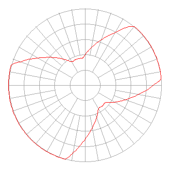 | ||||||||||||||||||
| Azimuth | Ratio | Azimuth | Ratio | Azimuth | Ratio | Azimuth | Ratio | ||||||||||||
| 0 | 0.398 | 10 | 0.501 | 20 | 0.631 | 30 | 0.794 | ||||||||||||
| 40 | 1.000 | 50 | 1.000 | 60 | 1.000 | 70 | 1.000 | ||||||||||||
| 80 | 1.000 | 85 | 1.000 | 90 | 0.891 | 100 | 0.708 | ||||||||||||
| 110 | 0.562 | 120 | 0.447 | 130 | 0.355 | 140 | 0.355 | ||||||||||||
| 150 | 0.355 | 160 | 0.447 | 170 | 0.562 | 180 | 0.708 | ||||||||||||
| 190 | 0.891 | 195 | 1.000 | 200 | 1.000 | 210 | 1.000 | ||||||||||||
| 220 | 1.000 | 230 | 1.000 | 240 | 1.000 | 250 | 1.000 | ||||||||||||
| 260 | 1.000 | 270 | 1.000 | 280 | 1.000 | 285 | 1.000 | ||||||||||||
| 290 | 0.891 | 300 | 0.708 | 310 | 0.562 | 320 | 0.447 | ||||||||||||
| 330 | 0.355 | 340 | 0.355 | 350 | 0.355 | 355 | 0.355 | ||||||||||||
Structure Registration Number 1224018 [ASR Heights Differ from KDLE Application] Structure Type: LTOWER Registered To: Pinnacle Towers LLC Structure Address: 21474 Vista Ridge Road Irvine, CA County Name: Orange County ASR Issued: 10/13/2022 Date Built: 09/03/1998 Site Elevation: 353.6 m (1160 ft.) Structure Height: 24.4 m (80 ft.) Height Overall: 27.1 m (89 ft.) Overall Height AMSL: 380.7 m (1249 ft.) FAA Determination: 05/01/2019 FAA Study #: 2019-AWP-4110-OE Paint & Light FAA Chapters: NONE PRIOR STUDY 2016-AWP-9507-OE 33-36-19.2 N 117-48-41.2 W (NAD 83) 33-36-19.1 N 117-48-38.0 W (Converted to NAD 27) |
2425 Olympic Blvd Ste 6000 W Santa Monica, CA 90404-4030 Phone: 310-447-3870 | Date: 12/15/2004 Application Certifier ENTRAVISION HOLDINGS, LLC Suite 6000 West 2425 Olympic Boulevard Santa Monica, CA 90404 Applicant ERIK C. SWANSON Hatfield & Dawson Consulting Engineers 9500 Greenwood Ave N Seattle, WA 98103 TECHNICAL CONSULTANT BARRY A. FRIEDMAN Thompson Hine Llp | |||||||||||||||||