
FCCInfo.com
A Service of Cavell, Mertz & Associates, Inc.
(855) FCC-INFO
|
|
W227DD from 08/02/2004 |
|
|
||||||||||||||||
|
|
W227DD Channel: 227D 93.3 MHz Brent, Alabama Service: FX - A translator or application for a translator. Facility ID: 157152 Fac. Service: FX Programming Delivery Method: Unspecified Status: License Application Accepted: 10/18/2016 Application Granted: 10/25/2016 File Number: BLFT-20161018AAJ License Expires: 00/00/0000 Prefix Type: This is a license for a translator Application Type: License To Cover FCC Website Links: LMS Facility Details This Application CDBS Application Other W227DD Applications Other W227DD Applications in CDBS Including Superseded Applications Mailing Address Correspondence for W227DD Correspondence related to application BLFT-20161018AAJ Service Contour - Open Street Map or USGS Map (60 dBu) Service Contour - KML / Google Earth (60 dBu) Class: D, A Noncommercial educational operating with no more than 10W Site Location: 33-09-36.4 N 87-30-54.0 W (NAD 83) Site Location: 33-09-36.0 N 87-30-54.0 W (Converted to NAD 27) Effective Radiated Power: 0.25 kW Transmitter Output Power: 0.16 kW Antenna Center HAAT: 0 m Antenna Center AMSL: 246 m (807 ft.) Antenna Center HAG: 127 m (417 ft.) Site Elevation: 119 m. (390 ft.) Height Overall*: 152 m (499 ft.) (* As Filed In This Application, may differ from ASR Data, Below.) Directional Antenna Antenna Make/Model: None Antenna ID: 123392 Polarization:
| ||||||||||||||||||
| Antenna Data for Antenna Id: 123392 W227DD FX File: BLFT-20161018AAJ None - Service: FX | 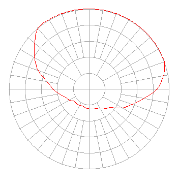 | ||||||||||||||||||
| Azimuth | Ratio | Azimuth | Ratio | Azimuth | Ratio | Azimuth | Ratio | ||||||||||||
| 0 | 1.000 | 10 | 1.000 | 20 | 1.000 | 30 | 1.000 | ||||||||||||
| 40 | 1.000 | 50 | 1.000 | 60 | 1.000 | 70 | 1.000 | ||||||||||||
| 80 | 0.944 | 90 | 0.851 | 100 | 0.694 | 110 | 0.574 | ||||||||||||
| 120 | 0.476 | 130 | 0.363 | 140 | 0.321 | 150 | 0.288 | ||||||||||||
| 160 | 0.262 | 170 | 0.255 | 180 | 0.248 | 190 | 0.241 | ||||||||||||
| 200 | 0.229 | 210 | 0.235 | 220 | 0.241 | 230 | 0.242 | ||||||||||||
| 240 | 0.282 | 250 | 0.310 | 260 | 0.372 | 270 | 0.452 | ||||||||||||
| 280 | 0.535 | 290 | 0.675 | 300 | 0.785 | 310 | 0.887 | ||||||||||||
| 320 | 0.988 | 330 | 1.000 | 340 | 1.000 | 350 | 1.000 | ||||||||||||
Structure Registration Number 1065251 [ASR Heights Differ from W227DD Application] Structure Type: GTOWER Registered To: Clearview Tower Company II, LLC Structure Address: 1700 Jug Factory Road Tuscaloosa, AL County Name: Tuscaloosa County ASR Issued: 09/11/2020 Date Built: 09/01/1984 Site Elevation: 120.7 m (396 ft.) Structure Height: 152.4 m (500 ft.) Height Overall: 152.4 m (500 ft.) Overall Height AMSL: 273.1 m (896 ft.) FAA Determination: 08/20/2020 FAA Study #: 2020-ASO-23330-OE FAA Circular #: 70/7460-1J Paint & Light FAA Chapters: 3, 4, 5, 13 OM&L to remain the same as prior studies = PAINT/RED LIGHTS 33-09-29.7 N 87-30-56.8 W (NAD 83) 33-09-29.3 N 87-30-56.8 W (Converted to NAD 27) |
1 Manhattanville Road Suite 202 Purchase, NY 10577 Phone: 203-861-0900 Limited Liability Company | Date: 10/18/2016 Application Certifier TOWNSQUARE MEDIA TUSCALOOSA LICENSE, LLC 240 Greenwich Avenue Greenwich, CT 06830 Applicant FRED W. GREAVES JR. 321 Kormit Dr Red Lion, PA 17356-8927 TECHNICAL CONSULTANT HOWARD M. LIBERMAN Wilkinson Barker Knauer Llp 1800 M Street, N.w. Suite 800n Washington, DC 20036 | |||||||||||||||||