
FCCInfo.com
A Service of Cavell, Mertz & Associates, Inc.
(855) FCC-INFO
|
|
W228CX from 12/04/2009 W228CX from 04/13/2004 |
|
|
||||||||||||||||
|
|
W228CX Channel: 228D 93.5 MHz Indianapolis, Indiana Service: FX - A translator or application for a translator. Facility ID: 150595 Fac. Service: FX Programming Delivery Method: Unspecified Status: License Application Accepted: 07/18/2019 Application Granted: 07/29/2019 File Number: BLFT-20190718AAG License Expires: 00/00/0000 Prefix Type: This is a license for a translator Application Type: License To Cover FCC Website Links: LMS Facility Details This Application CDBS Application Other W228CX Applications Other W228CX Applications in CDBS Including Superseded Applications Mailing Address Correspondence for W228CX Correspondence related to application BLFT-20190718AAG Service Contour - Open Street Map or USGS Map (60 dBu) Service Contour - KML / Google Earth (60 dBu) Class: D, A Noncommercial educational operating with no more than 10W Site Location: 39-46-03.2 N 86-00-11.9 W (NAD 83) Site Location: 39-46-03.0 N 86-00-12.0 W (Converted to NAD 27) Effective Radiated Power: 0.25 kW Transmitter Output Power: 0.254 kW Antenna Center HAAT: 0 m Antenna Center AMSL: 541 m (1775 ft.) Antenna Center HAG: 280 m (919 ft.) Site Elevation: 261 m. (856 ft.) Height Overall*: 303 m (994 ft.) (* As Filed In This Application, may differ from ASR Data, Below.) Directional Antenna Antenna Make/Model: None Antenna ID: 134038 Polarization:
| ||||||||||||||||||
| Antenna Data for Antenna Id: 134038 W228CX FX File: BLFT-20190718AAG None - Service: FX Pattern and Field Values Include a 280° Clockwise Rotation | 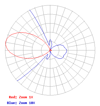 | ||||||||||||||||||
| Azimuth | Ratio | Azimuth | Ratio | Azimuth | Ratio | Azimuth | Ratio | ||||||||||||
| 0 | 0.023 | 10 | 0.018 | 20 | 0.011 | 30 | 0.002 | ||||||||||||
| 40 | 0.005 | 50 | 0.013 | 60 | 0.023 | 70 | 0.030 | ||||||||||||
| 80 | 0.033 | 90 | 0.037 | 100 | 0.036 | 110 | 0.033 | ||||||||||||
| 120 | 0.033 | 130 | 0.029 | 140 | 0.020 | 150 | 0.013 | ||||||||||||
| 160 | 0.006 | 170 | 0.002 | 180 | 0.011 | 190 | 0.017 | ||||||||||||
| 200 | 0.021 | 210 | 0.010 | 220 | 0.036 | 230 | 0.142 | ||||||||||||
| 240 | 0.319 | 250 | 0.537 | 260 | 0.758 | 270 | 0.933 | ||||||||||||
| 280 | 1.000 | 290 | 0.944 | 300 | 0.776 | 310 | 0.549 | ||||||||||||
| 320 | 0.323 | 330 | 0.146 | 340 | 0.036 | 350 | 0.011 | ||||||||||||
Structure Registration Number 1030144 Structure Type: TOWER Registered To: Subcarrier Communications Inc Structure Address: 9301 Burk Road Indianapolis, IN County Name: Marion County ASR Issued: 04/13/2022 Date Built: 01/01/1979 Site Elevation: 260.6 m (855 ft.) Structure Height: 302.3 m (992 ft.) Height Overall: 303.3 m (995 ft.) Overall Height AMSL: 563.9 m (1850 ft.) FAA Determination: 01/10/1978 FAA Study #: 77-GL-1673-OE Paint & Light FAA Chapters: 1, 3, 7, 16, 21 RED LIGHTS/PAINT 39-46-03.0 N 86-00-12.0 W (NAD 83) 39-46-02.8 N 86-00-12.1 W (Converted to NAD 27) |
1010 Wayne Avenue 14th Floor Silver Spring, MD 20910 Phone: 301-266-8476 Limited Liability Company | Date: 07/18/2019 Application Certifier EMMIS RADIO LICENSE, LLC One Emmis Plaza 40 Monument Circle, Suite 700 Indianapolis, IN 46204 Applicant DONALD LYNCH 111 Sam Houston Drive Kerrville, TX 78028 TECHNICAL CONSULTANT GREGORY L. MASTERS Wiley Rein Llp 1776 K Street, N.w. Washington, DC 20006 | |||||||||||||||||