
FCCInfo.com
A Service of Cavell, Mertz & Associates, Inc.
(855) FCC-INFO
|
|
|
|
|
||||||||||||||||
|
|
K290AG Channel: 290D 105.9 MHz Stockton, California Service: FX - A translator or application for a translator. Facility ID: 86382 Fac. Service: FX Programming Delivery Method: Unspecified Status: License Application Accepted: 03/06/2014 Application Granted: 04/16/2014 File Number: BLFT-20140306AAE License Expires: 00/00/0000 Prefix Type: This is a license for a translator Application Type: License To Cover FCC Website Links: LMS Facility Details This Application CDBS Application Other K290AG Applications Other K290AG Applications in CDBS Including Superseded Applications Mailing Address Correspondence for K290AG Correspondence related to application BLFT-20140306AAE Service Contour - Open Street Map or USGS Map (60 dBu) Service Contour - KML / Google Earth (60 dBu) Class: D, A Noncommercial educational operating with no more than 10W Site Location: 37-57-29.7 N 121-16-58.8 W (NAD 83) Site Location: 37-57-30.0 N 121-16-55.0 W (Converted to NAD 27) Effective Radiated Power: 0.25 kW Transmitter Output Power: 0.585 kW Antenna Center HAAT: 94.3 m Horiz.; 0 m Vert. Antenna Center AMSL: 104 m (341 ft.) Antenna Center HAG: 99 m (325 ft.) Site Elevation: 5 m. (16 ft.) Height Overall*: 123 m (404 ft.) (* As Filed In This Application, may differ from ASR Data, Below.) Directional Antenna Antenna Make/Model: None Antenna ID: 113632 Polarization:
| ||||||||||||||||||
| Antenna Data for Antenna Id: 113632 K290AG FX File: BLFT-20140306AAE None - Service: FX Pattern and Field Values Include a 80° Clockwise Rotation | 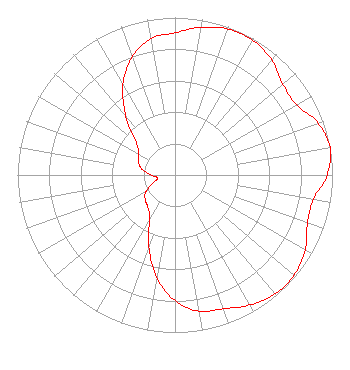 | ||||||||||||||||||
| Azimuth | Ratio | Azimuth | Ratio | Azimuth | Ratio | Azimuth | Ratio | ||||||||||||
| 0 | 0.904 | 10 | 0.952 | 20 | 0.986 | 30 | 0.987 | ||||||||||||
| 40 | 0.955 | 50 | 0.895 | 60 | 0.891 | 70 | 0.966 | ||||||||||||
| 80 | 1.000 | 90 | 0.966 | 100 | 0.891 | 110 | 0.895 | ||||||||||||
| 120 | 0.955 | 130 | 0.987 | 140 | 0.986 | 150 | 0.952 | ||||||||||||
| 160 | 0.904 | 170 | 0.878 | 180 | 0.798 | 190 | 0.662 | ||||||||||||
| 200 | 0.485 | 210 | 0.321 | 220 | 0.268 | 230 | 0.247 | ||||||||||||
| 240 | 0.215 | 250 | 0.150 | 260 | 0.112 | 270 | 0.150 | ||||||||||||
| 280 | 0.215 | 290 | 0.247 | 300 | 0.268 | 310 | 0.321 | ||||||||||||
| 320 | 0.485 | 330 | 0.662 | 340 | 0.798 | 350 | 0.878 | ||||||||||||
Structure Registration Number 1064433 [ASR Heights Differ from K290AG Application] Structure Type: TOWER Registered To: Bank of Stockton Trustee of the Ann Matlow Trust Structure Address: 721 E. Lindsay Street Stockton, CA County Name: San Joaquin County ASR Issued: 01/15/2018 Date Built: 04/12/1999 Site Elevation: 4.5 m (15 ft.) Structure Height: 121.9 m (400 ft.) Height Overall: 122.5 m (402 ft.) Overall Height AMSL: 127 m (417 ft.) FAA Determination: 03/13/2006 FAA Study #: 2006-AWP-880-OE FAA Circular #: 70/7460-1K Paint & Light FAA Chapters: 3, 4, 5, 12 PRIOR STUDY 1998-AWP-2582-OE 37-57-29.8 N 121-16-58.6 W (NAD 83) 37-57-30.1 N 121-16-54.8 W (Converted to NAD 27) |
P.o. Box 31477 Stockton, CA 95213 Phone: 209-948-5786 | Date: 03/06/2014 Application Certifier KNOX, INC. P.o. Box 31477 Stockton, CA 95213 Applicant ROBERT LARUE P.o. Box 31477 Stockton, CA 95213 APPLICANT RICHARD A. HELMICK Cohn And Marks Llp 1920 N Street, N.w. Suite 300 Washington, DC 20036-1622 | |||||||||||||||||