
FCCInfo.com
A Service of Cavell, Mertz & Associates, Inc.
(855) FCC-INFO
|
|
WRBT from 08/01/1995 WRBT from 09/14/1989 WRBT from 10/15/1988 |
|
|
|||||||||||||||||||
|
|
WRBT Channel: 235B 94.9 MHz Harrisburg, Pennsylvania Service: FM - A full-service FM station or application. Facility ID: 54019 Fac. Service: FM Analog & Digital Status: License Application Accepted: 01/31/2002 Application Granted: 04/01/2003 File Number: BMLH-20020131AAD License Expires: 00/00/0000 Prefix Type: This is a modification of a license for a commecial FM station Application Type: Minor Amendment FCC Website Links: LMS Facility Details This Application CDBS Application Other WRBT Applications Other WRBT Applications in CDBS Including Superseded Applications Mailing Address Correspondence for WRBT Correspondence related to application BMLH-20020131AAD Service Contour - Open Street Map or USGS Map (54 dBu) Service Contour - KML / Google Earth (54 dBu) Public Inspection Files History Cards for WRBT Facility Type: FM STATION Class: B, A Zone I or I-A station; with 25kW-50kW ERP and a class contour distance 39km-52km Site Location: 40-18-58.3 N 76-56-59.9 W (NAD 83) Site Location: 40-18-58.0 N 76-57-01.0 W (Converted to NAD 27) Effective Radiated Power: 25 kW Horiz. ; 24.5 kW Vert. Transmitter Output Power: 7.5 kW Antenna Center HAAT: 213 m (699 ft.) Antenna Center AMSL: 370 m (1214 ft.) Antenna Center HAG: 41 m (135 ft.) Calculated Site Elevation: 329 m. (1079 ft.) Height Overall*: 186 m (610 ft.) (* As Filed In This Application, may differ from ASR Data, Below.) Directional Antenna Antenna Make/Model: Shivley 6810-4D-DA Antenna ID: 13825 Polarization: | |||||||||||||||||||||
| Antenna Data for Antenna Id: 13825 WRBT FM File: BMLH-20020131AAD Shivley - 6810-4D-DA Service: FM | 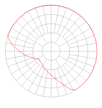 | |||||||||||||||||||||
| Azimuth | Ratio | Azimuth | Ratio | Azimuth | Ratio | Azimuth | Ratio | |||||||||||||||
| 0 | 1.000 | 10 | 1.000 | 20 | 1.000 | 30 | 1.000 | |||||||||||||||
| 40 | 1.000 | 50 | 1.000 | 60 | 1.000 | 70 | 1.000 | |||||||||||||||
| 80 | 1.000 | 90 | 1.000 | 100 | 1.000 | 110 | 1.000 | |||||||||||||||
| 120 | 1.000 | 130 | 1.000 | 140 | 1.000 | 150 | 0.975 | |||||||||||||||
| 160 | 0.770 | 170 | 0.620 | 180 | 0.520 | 190 | 0.450 | |||||||||||||||
| 200 | 0.400 | 210 | 0.360 | 220 | 0.335 | 230 | 0.320 | |||||||||||||||
| 236 | 0.315 | 240 | 0.340 | 250 | 0.430 | 260 | 0.550 | |||||||||||||||
| 270 | 0.690 | 280 | 0.860 | 290 | 1.000 | 300 | 1.000 | |||||||||||||||
| 310 | 1.000 | 320 | 1.000 | 330 | 1.000 | 340 | 1.000 | |||||||||||||||
| 350 | 1.000 | |||||||||||||||||||||
Structure Registration Number 1033740 [ASR Heights Differ from WRBT Application] Structure Type: LTOWER Registered To: Nexstar Media Inc. Structure Address: Tower Road On Blue Mountain Summerdale, PA County Name: Cumberland County ASR Issued: 05/28/2021 Date Built: 03/01/1996 Site Elevation: 329.2 m (1080 ft.) Structure Height: 167.7 m (550 ft.) Height Overall: 187 m (614 ft.) Overall Height AMSL: 516.2 m (1694 ft.) FAA Determination: 02/27/2015 FAA Study #: 2014-AEA-7355-OE FAA Circular #: 70/7460-1J Paint & Light FAA Chapters: 3, 4, 5, 13 OM&L to remain the same as prior study = PAINT/RED LIGHTS 40-18-57.8 N 76-57-01.0 W (NAD 83) 40-18-57.5 N 76-57-02.1 W (Converted to NAD 27) |
7136 S. Yale Avenue Tulsa, OK 74136 Phone: 918-664-4581 | Date: 01/31/2002 Application Certifier CLEAR CHANNEL BROADCASTING LICENSES, INC. 7136 S. Yale Avenue Suite 501 Tulsa, OK 74136-2623 Applicant TROY G. LANGHAM 2625 S. Memorial Drive Suite A Tulsa, OK 74129 FCC APPLICATIONS SPECIALIST MARISSA G. REPP Hogan & Hartson L.l.p. | ||||||||||||||||||||
|
| |||||||||||||||||||||