
FCCInfo.com
A Service of Cavell, Mertz & Associates, Inc.
(855) FCC-INFO
|
|
W203BY from 01/07/1997 |
|
|
||||||||||||||||
|
|
W203BY Channel: 203D 88.5 MHz Warner Robins, Georgia Service: FX - A translator or application for a translator. Facility ID: 77535 Fac. Service: FX Programming Delivery Method: Unspecified Status: License Application Accepted: 06/02/2016 Application Granted: 06/20/2016 File Number: BLFT-20160602AAQ License Expires: 00/00/0000 Prefix Type: This is a license for a translator Application Type: License To Cover FCC Website Links: LMS Facility Details This Application CDBS Application Other W203BY Applications Other W203BY Applications in CDBS Including Superseded Applications Mailing Address Correspondence for W203BY Correspondence related to application BLFT-20160602AAQ Service Contour - Open Street Map or USGS Map (60 dBu) Service Contour - KML / Google Earth (60 dBu) Class: D, A Noncommercial educational operating with no more than 10W Site Location: 32-36-26.5 N 83-36-07.7 W (NAD 83) Site Location: 32-36-26.0 N 83-36-08.0 W (Converted to NAD 27) Effective Radiated Power: 0 kW Horiz. ; 0.019 kW Vert. Transmitter Output Power: 0.021 kW Antenna Center HAAT: 0 m Antenna Center AMSL: 0 m Horiz.; 186 m Vert. Antenna Center HAG: 0 m Horiz.; 95 m Vert. Site Elevation: 91 m. (299 ft.) Height Overall*: 106 m (348 ft.) (* As Filed In This Application, may differ from ASR Data, Below.) Directional Antenna Antenna Make/Model: None Antenna ID: 31326 Polarization:
| ||||||||||||||||||
| Antenna Data for Antenna Id: 31326 W203BY FX File: BLFT-20160602AAQ None - Service: FX Pattern and Field Values Include a 255° Clockwise Rotation | 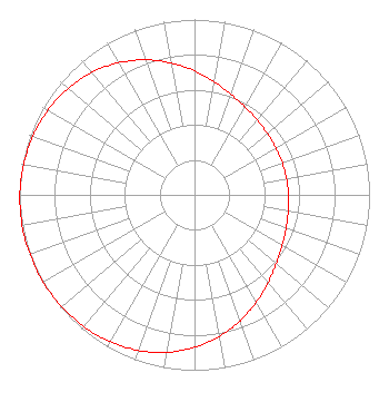 | ||||||||||||||||||
| Azimuth | Ratio | Azimuth | Ratio | Azimuth | Ratio | Azimuth | Ratio | ||||||||||||
| 5 | 0.679 | 15 | 0.630 | 25 | 0.592 | 35 | 0.566 | ||||||||||||
| 45 | 0.549 | 55 | 0.540 | 65 | 0.535 | 75 | 0.534 | ||||||||||||
| 85 | 0.535 | 95 | 0.540 | 105 | 0.549 | 115 | 0.566 | ||||||||||||
| 125 | 0.592 | 135 | 0.630 | 145 | 0.679 | 155 | 0.735 | ||||||||||||
| 165 | 0.792 | 175 | 0.845 | 185 | 0.892 | 195 | 0.929 | ||||||||||||
| 205 | 0.956 | 215 | 0.975 | 225 | 0.987 | 235 | 0.995 | ||||||||||||
| 245 | 0.999 | 255 | 1.000 | 265 | 0.999 | 275 | 0.995 | ||||||||||||
| 285 | 0.987 | 295 | 0.975 | 305 | 0.956 | 315 | 0.929 | ||||||||||||
| 325 | 0.892 | 335 | 0.845 | 345 | 0.792 | 355 | 0.735 | ||||||||||||
Structure Registration Number 1054179 [ASR Heights Differ from W203BY Application] Structure Type: GTOWER Registered To: Crown Castle Towers 06-2 LLC Structure Address: 108 Wellborn Rd Warner Robins, GA County Name: Houston County ASR Issued: 11/22/2016 Date Built: 01/05/1999 Site Elevation: 93.9 m (308 ft.) Structure Height: 101.2 m (332 ft.) Height Overall: 106.9 m (351 ft.) Overall Height AMSL: 200.8 m (659 ft.) FAA Determination: 11/21/2016 FAA Study #: 2016-ASO-23753-OE FAA Circular #: 70/7460-1J Paint & Light FAA Chapters: 4, 6, 13 PRIOR STUDY 1998-ASO-7283-OE 32-36-26.8 N 83-36-08.3 W (NAD 83) 32-36-26.3 N 83-36-08.6 W (Converted to NAD 27) |
P.o. Box 391 4002 N. 3300 E. Twin Falls, ID 83303 Phone: 208-733-3133 | Date: 06/02/2016 Application Certifier CALVARY CHAPEL OF TWIN FALLS, INC. Po Box 391 Twin Falls, ID 83303 Applicant LOIS MILLS Po Box 391 Twin Falls, ID 83301 APPLICATION TECHNICIAN CARY TEPPER Tepper Law Firm, Llc 4900 Auburn Avenue, Suite 100 Bethesda, MD 20814-2632 | |||||||||||||||||