
FCCInfo.com
A Service of Cavell, Mertz & Associates, Inc.
(855) FCC-INFO
|
|
KRRN from 12/10/2002 KRRN from 10/24/1989 KRRN from 04/25/1985 |
|
|
||||||||||||||||
|
|
KRRN Channel: 224C 92.7 MHz Moapa Valley, Nevada Service: FS - A full service FM station auxiliary transmitting antenna or application. Facility ID: 27982 Fac. Service: FM Status: License Application Accepted: 04/22/2014 Application Granted: 05/01/2014 File Number: BXLH-20140422AAD License Expires: 00/00/0000 Prefix Type: This is BXLH Application Type: License To Cover FCC Website Links: LMS Facility Details This Application CDBS Application Other KRRN Applications Other KRRN Applications in CDBS Including Superseded Applications Mailing Address Correspondence for KRRN Correspondence related to application BXLH-20140422AAD Service Contour - Open Street Map or USGS Map (60 dBu) Service Contour - KML / Google Earth (60 dBu) Public Inspection Files Facility Type: FM STATION Class: C, A Zone II station; with exactly 100kW ERP and a class contour distance 72km-92km Site Location: 36-19-59.9 N 115-21-44.0 W (NAD 83) Site Location: 36-20-00.0 N 115-21-41.0 W (Converted to NAD 27) Effective Radiated Power: 20 kW Transmitter Output Power: 5.37 kW Antenna Center HAAT: 6 m (20 ft.) Antenna Center AMSL: 1079 m (3540 ft.) Antenna Center HAG: 92 m (302 ft.) Calculated Site Elevation: 987 m. (3238 ft.) Height Overall*: 122 m (400 ft.) (* As Filed In This Application, may differ from ASR Data, Below.) Directional Antenna Antenna Make/Model: Propagation System Inc PSIFMP-2-DA, two sections Antenna ID: 118156 Polarization:
| ||||||||||||||||||
| Antenna Data for Antenna Id: 118156 KRRN FS File: BXLH-20140422AAD Propagation System Inc - PSIFMP-2-DA, two sections Service: FS | 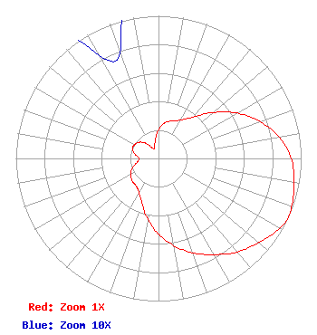 | ||||||||||||||||||
| Azimuth | Ratio | Azimuth | Ratio | Azimuth | Ratio | Azimuth | Ratio | ||||||||||||
| 0 | 0.202 | 10 | 0.254 | 20 | 0.280 | 30 | 0.311 | ||||||||||||
| 40 | 0.379 | 50 | 0.501 | 60 | 0.635 | 70 | 0.757 | ||||||||||||
| 80 | 0.859 | 90 | 0.931 | 100 | 0.964 | 110 | 0.993 | ||||||||||||
| 115 | 1.000 | 120 | 0.979 | 130 | 0.918 | 140 | 0.857 | ||||||||||||
| 150 | 0.779 | 160 | 0.705 | 170 | 0.620 | 180 | 0.531 | ||||||||||||
| 190 | 0.435 | 200 | 0.336 | 210 | 0.275 | 220 | 0.247 | ||||||||||||
| 230 | 0.242 | 240 | 0.226 | 250 | 0.195 | 260 | 0.152 | ||||||||||||
| 270 | 0.135 | 280 | 0.167 | 290 | 0.195 | 300 | 0.193 | ||||||||||||
| 310 | 0.177 | 320 | 0.139 | 330 | 0.084 | 340 | 0.079 | ||||||||||||
| 350 | 0.131 | ||||||||||||||||||
Structure Registration Number 1255600 Structure Type: TOWER Registered To: Entravision Communications Corporation Structure Address: 3 Miles West Of Intersection Of Highway 95 And Kyle Canyon Rd. Las Vegas, NV County Name: Clark County ASR Issued: 07/21/2012 Date Built: 03/28/2008 Site Elevation: 987.2 m (3239 ft.) Structure Height: 121.9 m (400 ft.) Height Overall: 121.9 m (400 ft.) Overall Height AMSL: 1109.1 m (3639 ft.) FAA Determination: 04/25/2011 FAA Study #: 2011-AWP-2038-OE FAA Circular #: 70/7460-1K Paint & Light FAA Chapters: 4, 6, 12 PRIOR STUDY 2008-AWP-1172-OE 36-20-00.0 N 115-21-44.0 W (NAD 83) 36-20-00.1 N 115-21-41.0 W (Converted to NAD 27) |
2425 Olympic Blvd, Suite 6000 W Santa Monica, CA 90404-4030 Phone: 310-447-3870 | Date: 04/22/2014 Application Certifier ENTRAVISION HOLDINGS, LLC Suite 6000 West 2425 Olympic Boulevard Santa Monica, CA 90404 Applicant RICHARD HUNT 5700 Wilshire Blvd Suite 250 Los Angeles, CA 90036 VP OF ENGINEERING - WEST BARRY A. FRIEDMAN Thompson Hine Llp | |||||||||||||||||