
FCCInfo.com
A Service of Cavell, Mertz & Associates, Inc.
(855) FCC-INFO
|
|
|
|
|
||||||||||||||||
|
|
W276DT Channel: 276D 103.1 MHz Falls Church, Virginia Service: FX - A translator or application for a translator. Facility ID: 202256 Fac. Service: FX Programming Delivery Method: Unspecified Status: License Application Accepted: 09/16/2019 Application Granted: 10/04/2019 File Number: BLFT-20190916ABK License Expires: 00/00/0000 Prefix Type: This is a license for a translator Application Type: License To Cover FCC Website Links: LMS Facility Details This Application CDBS Application Other W276DT Applications Other W276DT Applications in CDBS Including Superseded Applications Mailing Address Correspondence for W276DT Correspondence related to application BLFT-20190916ABK Service Contour - Open Street Map or USGS Map (60 dBu) Service Contour - KML / Google Earth (60 dBu) Class: D, A Noncommercial educational operating with no more than 10W Site Location: 38-52-20.0 N 77-13-50.9 W (NAD 83) Site Location: 38-52-19.6 N 77-13-52.0 W (Converted to NAD 27) Effective Radiated Power: 0.1 kW Transmitter Output Power: 0.05 kW Antenna Center HAAT: 0 m Antenna Center AMSL: 190 m (623 ft.) Antenna Center HAG: 85 m (279 ft.) Site Elevation: 105 m. (344 ft.) Height Overall*: 97 m (318 ft.) (* As Filed In This Application, may differ from ASR Data, Below.) Directional Antenna Antenna Make/Model: None Antenna ID: 134167 Polarization:
| ||||||||||||||||||
| Antenna Data for Antenna Id: 134167 W276DT FX File: BLFT-20190916ABK None - Service: FX Pattern and Field Values Include a 130° Clockwise Rotation | 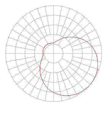 | ||||||||||||||||||
| Azimuth | Ratio | Azimuth | Ratio | Azimuth | Ratio | Azimuth | Ratio | ||||||||||||
| 0 | 0.220 | 10 | 0.250 | 20 | 0.290 | 30 | 0.360 | ||||||||||||
| 40 | 0.440 | 50 | 0.530 | 60 | 0.630 | 70 | 0.730 | ||||||||||||
| 80 | 0.810 | 90 | 0.880 | 100 | 0.930 | 110 | 0.970 | ||||||||||||
| 120 | 0.990 | 130 | 1.000 | 140 | 0.990 | 150 | 0.970 | ||||||||||||
| 160 | 0.930 | 170 | 0.880 | 180 | 0.810 | 190 | 0.730 | ||||||||||||
| 200 | 0.630 | 210 | 0.530 | 220 | 0.440 | 230 | 0.360 | ||||||||||||
| 240 | 0.290 | 250 | 0.250 | 260 | 0.220 | 270 | 0.220 | ||||||||||||
| 280 | 0.220 | 290 | 0.230 | 300 | 0.230 | 310 | 0.230 | ||||||||||||
| 320 | 0.230 | 330 | 0.230 | 340 | 0.220 | 350 | 0.220 | ||||||||||||
Structure Registration Number 1035358 Structure Type: TOWER Registered To: American Towers LLC Structure Address: 2917 Eskridge Road Merrifield, VA County Name: Fairfax County ASR Issued: 01/05/2021 Date Built: 06/01/1983 Site Elevation: 105.2 m (345 ft.) Structure Height: 93 m (305 ft.) Height Overall: 96.9 m (318 ft.) Overall Height AMSL: 202.1 m (663 ft.) FAA Determination: 06/11/1997 FAA Study #: 97-AEA-1018-OE FAA Circular #: 70/7460-1J Paint & Light FAA Chapters: 3, 4, 5, 13 38-52-20.0 N 77-13-51.0 W (NAD 83) 38-52-19.6 N 77-13-52.1 W (Converted to NAD 27) |
1406 E. Garden Lane Midland, TX 79701 Phone: 432-682-1485 | Date: 09/16/2019 Application Certifier LA PROMESA FOUNDATION 1406 E. Garden Lane Midland, TX 79701 Applicant TIMOTHY Z. SAWYER T Z Sawyer Technical Consultants 2130 Hutchison Grove Court, Suite 100 Falls Church, VA 22043 CONSULTING ENGINEER DENNIS J. KELLY Law Office Of Dennis J. Kelly Post Office Box 41177 Washington, DC 20018-0577 | |||||||||||||||||