
FCCInfo.com
A Service of Cavell, Mertz & Associates, Inc.
(855) FCC-INFO
|
|
|
|
|
||||||||||||||||
|
|
W273DH Channel: 273D 102.5 MHz High Point, North Carolina Service: FX - A translator or application for a translator. Facility ID: 201317 Fac. Service: FX Programming Delivery Method: Unspecified Status: License Application Accepted: 03/15/2019 Application Granted: 03/27/2019 File Number: BLFT-20190315AAZ License Expires: 00/00/0000 Prefix Type: This is a license for a translator Application Type: License To Cover FCC Website Links: LMS Facility Details This Application CDBS Application Other W273DH Applications Other W273DH Applications in CDBS Including Superseded Applications Mailing Address Correspondence for W273DH Correspondence related to application BLFT-20190315AAZ Service Contour - Open Street Map or USGS Map (60 dBu) Service Contour - KML / Google Earth (60 dBu) Class: D, A Noncommercial educational operating with no more than 10W Site Location: 35-55-11.5 N 80-01-46.1 W (NAD 83) Site Location: 35-55-11.0 N 80-01-47.0 W (Converted to NAD 27) Effective Radiated Power: 0.04 kW Transmitter Output Power: 0.082 kW Antenna Center HAAT: 0 m Antenna Center AMSL: 379 m (1243 ft.) Antenna Center HAG: 87 m (285 ft.) Site Elevation: 257 m. (843 ft.) Height Overall*: 114 m (374 ft.) (* As Filed In This Application, may differ from ASR Data, Below.) Directional Antenna Antenna Make/Model: None Antenna ID: 130060 Polarization:
| ||||||||||||||||||
| Antenna Data for Antenna Id: 130060 W273DH FX File: BLFT-20190315AAZ None - Service: FX | 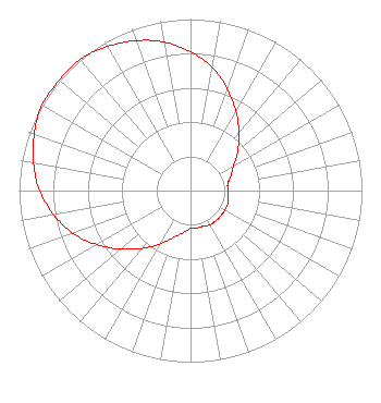 | ||||||||||||||||||
| Azimuth | Ratio | Azimuth | Ratio | Azimuth | Ratio | Azimuth | Ratio | ||||||||||||
| 0 | 0.810 | 10 | 0.730 | 20 | 0.630 | 30 | 0.530 | ||||||||||||
| 40 | 0.440 | 50 | 0.360 | 60 | 0.290 | 70 | 0.250 | ||||||||||||
| 80 | 0.220 | 90 | 0.220 | 100 | 0.220 | 110 | 0.230 | ||||||||||||
| 120 | 0.230 | 130 | 0.230 | 140 | 0.230 | 150 | 0.230 | ||||||||||||
| 160 | 0.220 | 170 | 0.220 | 180 | 0.220 | 190 | 0.250 | ||||||||||||
| 200 | 0.290 | 210 | 0.360 | 220 | 0.440 | 230 | 0.530 | ||||||||||||
| 240 | 0.630 | 250 | 0.730 | 260 | 0.810 | 270 | 0.880 | ||||||||||||
| 280 | 0.930 | 290 | 0.970 | 300 | 1.000 | 310 | 1.000 | ||||||||||||
| 320 | 1.000 | 330 | 0.970 | 340 | 0.930 | 350 | 0.880 | ||||||||||||
Structure Registration Number 1007022 Structure Type: Registered To: American Towers LLC Structure Address: 1655 Kersey Valley Road (#90243) High Point, NC County Name: Guilford County ASR Issued: 06/15/2016 Date Built: 02/06/1998 Site Elevation: 256.6 m (842 ft.) Structure Height: 109.1 m (358 ft.) Height Overall: 114.3 m (375 ft.) Overall Height AMSL: 370.9 m (1217 ft.) FAA Determination: 03/14/2006 FAA Study #: 2006-ASO-1083-OE FAA Circular #: 70/7460-1K Paint & Light FAA Chapters: 4, 8, 12 PRIOR STUDY 1991-ASO-2145-OE 35-55-36.0 N 79-56-03.9 W (NAD 83) 35-55-35.5 N 79-56-04.8 W (Converted to NAD 27) |
4405 Providence Lane Suite D Winston-salem, NC 27106 Phone: 336-759-0363 Corporation | Date: 03/15/2019 Application Certifier TRUTH BROADCASTING CORPORATION 4405 Providence Lane Suite D Winston-salem, NC 27106 Applicant CARL E GLUCK Carl T Jones Corp 7901 Yarnwood Court Springfield, VA 22153-2899 TECHNICAL CONSULTANT DAVINA SASHKIN, ESQ. Fletcher, Heald & Hildreth, Plc 1300 North 17th Street 11th Floor Arlington, VA 22209 | |||||||||||||||||