
FCCInfo.com
A Service of Cavell, Mertz & Associates, Inc.
(855) FCC-INFO
|
|
|
|
|
||||||||||||||||
|
|
K220HE Channel: 220D 91.9 MHz Chehalis, Washington Service: FX - A translator or application for a translator. Facility ID: 91974 Fac. Service: FX Programming Delivery Method: Unspecified Status: License Application Accepted: 06/28/2016 Application Granted: 07/11/2016 File Number: BLFT-20160628AAB License Expires: 00/00/0000 Prefix Type: This is a license for a translator Application Type: License To Cover FCC Website Links: LMS Facility Details This Application CDBS Application Other K220HE Applications Other K220HE Applications in CDBS Including Superseded Applications Mailing Address Correspondence for K220HE Correspondence related to application BLFT-20160628AAB Service Contour - Open Street Map or USGS Map (60 dBu) Service Contour - KML / Google Earth (60 dBu) Class: D, A Noncommercial educational operating with no more than 10W Site Location: 46-33-15.4 N 123-03-30.5 W (NAD 83) Site Location: 46-33-16.0 N 123-03-26.0 W (Converted to NAD 27) Effective Radiated Power: 0 kW Horiz. ; 0.016 kW Vert. Transmitter Output Power: 0.016 kW Antenna Center HAAT: 0 m Antenna Center AMSL: 0 m Horiz.; 480 m Vert. Antenna Center HAG: 0 m Horiz.; 39 m Vert. Site Elevation: 441 m. (1447 ft.) Height Overall*: 71 m (233 ft.) (* As Filed In This Application, may differ from ASR Data, Below.) Directional Antenna Antenna Make/Model: None Antenna ID: 31326 Polarization:
| ||||||||||||||||||
| Antenna Data for Antenna Id: 31326 K220HE FX File: BLFT-20160628AAB None - Service: FX Pattern and Field Values Include a 70° Clockwise Rotation | 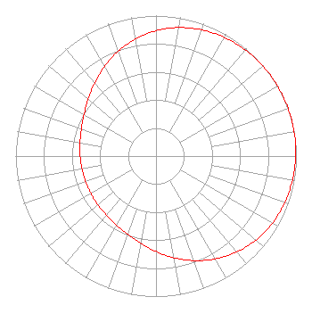 | ||||||||||||||||||
| Azimuth | Ratio | Azimuth | Ratio | Azimuth | Ratio | Azimuth | Ratio | ||||||||||||
| 0 | 0.892 | 10 | 0.929 | 20 | 0.956 | 30 | 0.975 | ||||||||||||
| 40 | 0.987 | 50 | 0.995 | 60 | 0.999 | 70 | 1.000 | ||||||||||||
| 80 | 0.999 | 90 | 0.995 | 100 | 0.987 | 110 | 0.975 | ||||||||||||
| 120 | 0.956 | 130 | 0.929 | 140 | 0.892 | 150 | 0.845 | ||||||||||||
| 160 | 0.792 | 170 | 0.735 | 180 | 0.679 | 190 | 0.630 | ||||||||||||
| 200 | 0.592 | 210 | 0.566 | 220 | 0.549 | 230 | 0.540 | ||||||||||||
| 240 | 0.535 | 250 | 0.534 | 260 | 0.535 | 270 | 0.540 | ||||||||||||
| 280 | 0.549 | 290 | 0.566 | 300 | 0.592 | 310 | 0.630 | ||||||||||||
| 320 | 0.679 | 330 | 0.735 | 340 | 0.792 | 350 | 0.845 | ||||||||||||
Structure Registration Number 1033564 Structure Type: TOWER Registered To: CENTRALIA SCHOOL DISTRICT Structure Address: On Crego Hill 12 Mi S Centralia Chehalis, WA County Name: Lewis County ASR Issued: 11/14/1997 Date Built: 06/20/1982 Site Elevation: 441 m (1447 ft.) Structure Height: 51 m (167 ft.) Height Overall: 71 m (233 ft.) Overall Height AMSL: 512 m (1680 ft.) FAA Determination: 03/11/1982 FAA Study #: 82-ANM-068-OE FAA Circular #: 70/7460-1F Paint & Light FAA Chapters: 3, 5, 9 RED LIGHTS/PAINT 46-33-15.0 N 123-03-30.0 W (NAD 83) 46-33-15.6 N 123-03-25.5 W (Converted to NAD 27) |
P.o. Box 391 4002 N. 3300 E. Twin Falls, ID 83303 Phone: 208-733-3133 | Date: 06/28/2016 Application Certifier CALVARY CHAPEL OF TWIN FALLS, INC. Po Box 391 Twin Falls, ID 83303 Applicant LOIS MILLS Po Box 391 Twin Falls, ID 83303 APPLICATION TECHNICIAN CARY TEPPER Tepper Law Firm, Llc 4900 Auburn Avenue, Suite 100 Bethesda, MD 20814-2632 | |||||||||||||||||