
FCCInfo.com
A Service of Cavell, Mertz & Associates, Inc.
(855) FCC-INFO
|
|
|
|
|
||||||||||||||||
|
|
W246CS Channel: 246D 97.1 MHz Chester Springs, Pennsylvania Service: FX - A translator or application for a translator. Facility ID: 140819 Fac. Service: FX Programming Delivery Method: Unspecified Status: License Application Accepted: 10/20/2016 Application Granted: 10/28/2016 File Number: BLFT-20161020ACG License Expires: 00/00/0000 Prefix Type: This is a license for a translator Application Type: License To Cover FCC Website Links: LMS Facility Details This Application CDBS Application Other W246CS Applications Other W246CS Applications in CDBS Including Superseded Applications Mailing Address Correspondence for W246CS Correspondence related to application BLFT-20161020ACG Service Contour - Open Street Map or USGS Map (60 dBu) Service Contour - KML / Google Earth (60 dBu) Class: D, A Noncommercial educational operating with no more than 10W Site Location: 40-03-31.4 N 75-35-52.7 W (NAD 83) Site Location: 40-03-31.0 N 75-35-54.0 W (Converted to NAD 27) Effective Radiated Power: 0.01 kW Transmitter Output Power: 0.032 kW Antenna Center HAAT: 0 m Antenna Center AMSL: 346 m (1135 ft.) Antenna Center HAG: 127 m (417 ft.) Site Elevation: 219 m. (719 ft.) Height Overall*: 137 m (449 ft.) (* As Filed In This Application, may differ from ASR Data, Below.) Directional Antenna Antenna Make/Model: None Antenna ID: 124933 Polarization:
| ||||||||||||||||||
| Antenna Data for Antenna Id: 124933 W246CS FX File: BLFT-20161020ACG None - Service: FX | 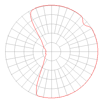 | ||||||||||||||||||
| Azimuth | Ratio | Azimuth | Ratio | Azimuth | Ratio | Azimuth | Ratio | ||||||||||||
| 0 | 1.000 | 10 | 1.000 | 20 | 1.000 | 30 | 1.000 | ||||||||||||
| 40 | 1.000 | 50 | 0.915 | 60 | 1.000 | 70 | 1.000 | ||||||||||||
| 80 | 1.000 | 90 | 1.000 | 100 | 1.000 | 110 | 1.000 | ||||||||||||
| 120 | 1.000 | 130 | 1.000 | 140 | 1.000 | 150 | 1.000 | ||||||||||||
| 160 | 1.000 | 170 | 1.000 | 180 | 1.000 | 190 | 1.000 | ||||||||||||
| 200 | 0.950 | 210 | 0.410 | 220 | 0.240 | 230 | 0.180 | ||||||||||||
| 240 | 0.135 | 250 | 0.135 | 260 | 0.125 | 270 | 0.120 | ||||||||||||
| 280 | 0.125 | 290 | 0.145 | 300 | 0.195 | 310 | 0.250 | ||||||||||||
| 320 | 0.390 | 330 | 0.900 | 340 | 1.000 | 350 | 1.000 | ||||||||||||
Structure Registration Number 1030858 Structure Type: LTOWER Registered To: American Towers LLC Structure Address: 67-d Valley Hill Rd. Charlestown Twp. 3 Phase (010100) Malvern, PA County Name: Chester County ASR Issued: 10/03/2022 Date Built: 05/01/2006 Site Elevation: 219.2 m (719 ft.) Structure Height: 132 m (433 ft.) Height Overall: 137.2 m (450 ft.) Overall Height AMSL: 356.4 m (1169 ft.) FAA Determination: 09/30/2022 FAA Study #: 2021-AEA-15689-OE FAA Circular #: 70/7460-1K Paint & Light FAA Chapters: 4, 8, 12 PRIOR STUDY 2011-AEA-3228-OE 40-03-31.6 N 75-35-52.8 W (NAD 83) 40-03-31.2 N 75-35-54.1 W (Converted to NAD 27) |
55 East Main Street Marlton, NJ 08053 Phone: 856-983-8844 | Date: 10/20/2016 Application Certifier HOPE CHRISTIAN CHURCH OF MARLTON, INC. 55 East Main Street Marlton, NJ 08053 Applicant WILLIAM C. LUEBKEMANN, JR. 55 East Main Street Marlton, NJ 08053 PRESIDENT/CHIEF ENGINEER MATTHEW MCCORMICK Fletcher, Heald & Hildreth, Plc 1300 North 17th Street 11th Floor Arlington, VA 22209 | |||||||||||||||||