
FCCInfo.com
A Service of Cavell, Mertz & Associates, Inc.
(855) FCC-INFO
|
|
|
|  |
|
||||||||||||||||||
|
|
WSNC Channel: 213C3 90.5 MHz Winston-salem, North Carolina Service: FM - A full-service FM station or application. Facility ID: 72969 Fac. Service: FM Status: License Application Accepted: 02/18/1993 Application Granted: 12/28/1993 File Number: BLED-19930218KA License Expires: 12/01/1995 Prefix Type: This is a license for a noncommercial educational FM station Application Type: License To Cover FCC Website Links: LMS Facility Details This Application CDBS Application Other WSNC Applications Other WSNC Applications in CDBS Including Superseded Applications Mailing Address Correspondence for WSNC Correspondence related to application BLED-19930218KA Service Contour - Open Street Map or USGS Map (60 dBu) Service Contour - KML / Google Earth (60 dBu) Public Inspection Files Facility Type: NON-COMMERCIAL EDUC. FM Class: C3, A Zone II station; with 6kW-25kW ERP and a class contour distance 28km-39km Site Location: 36-05-24.5 N 80-13-19.2 W (NAD 83) Site Location: 36-05-24.0 N 80-13-20.0 W (Converted to NAD 27) Effective Radiated Power: 10 kW Antenna Center HAAT: 59 m (194 ft.) Antenna Center AMSL: 319 m (1047 ft.) Antenna Center HAG: 81 m (266 ft.) Calculated Site Elevation: 238 m. (781 ft.) Height Overall*: 98 m (322 ft.) (* As Filed In This Application, may differ from ASR Data, Below.) Directional Antenna Antenna Make/Model: Oddball; usually designed by Applicant ODD870424MA Antenna ID: 13770 Polarization: | |||||||||||||||||||||
| Antenna Data for Antenna Id: 13770 WSNC FM File: BLED-19930218KA Oddball; usually designed by Applicant - ODD870424MA Service: FM | 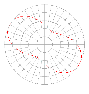 | |||||||||||||||||||||
| Azimuth | Ratio | Azimuth | Ratio | Azimuth | Ratio | Azimuth | Ratio | |||||||||||||||
| 0 | 0.490 | 10 | 0.420 | 20 | 0.380 | 30 | 0.370 | |||||||||||||||
| 40 | 0.380 | 50 | 0.420 | 60 | 0.490 | 70 | 0.580 | |||||||||||||||
| 80 | 0.690 | 90 | 0.810 | 100 | 0.910 | 110 | 0.980 | |||||||||||||||
| 120 | 1.000 | 130 | 0.980 | 140 | 0.910 | 150 | 0.810 | |||||||||||||||
| 160 | 0.690 | 170 | 0.580 | 180 | 0.490 | 190 | 0.420 | |||||||||||||||
| 200 | 0.380 | 210 | 0.370 | 220 | 0.380 | 230 | 0.420 | |||||||||||||||
| 240 | 0.490 | 250 | 0.580 | 260 | 0.690 | 270 | 0.810 | |||||||||||||||
| 280 | 0.910 | 290 | 0.980 | 300 | 1.000 | 310 | 0.980 | |||||||||||||||
| 320 | 0.910 | 330 | 0.810 | 340 | 0.690 | 350 | 0.580 | |||||||||||||||
Structure Registration Number 1004638 [ASR Heights Differ from WSNC Application] Structure Type: LTOWER Registered To: Crown Castle GT Company LLC Structure Address: 2095 E 1st St Winston Salem, NC County Name: Forsyth County ASR Issued: 08/25/2021 Date Built: 10/29/1999 Site Elevation: 248.1 m (814 ft.) Structure Height: 76.2 m (250 ft.) Height Overall: 79.2 m (260 ft.) Overall Height AMSL: 327.3 m (1074 ft.) FAA Determination: 07/28/2021 FAA Study #: 2021-ASO-18952-OE FAA Circular #: 70/7460-1K Paint & Light FAA Chapters: 4, 8, 12 OM&L to remain the same as prior study = A MED-DUAL SYSTEM 36-05-46.3 N 80-12-58.0 W (NAD 83) 36-05-45.8 N 80-12-58.8 W (Converted to NAD 27) |
P.o. Box 13095 Winston-salem, NC 27110 Not-for-Profit | Date: 02/18/1993 Application Certifier WINSTON-SALEM STATE UNIVERSITY Winston-salem State University P.o. Box 13095 Winston-salem, NC 27110 Applicant | ||||||||||||||||||||
| ||||||||||||||||||||||