
FCCInfo.com
A Service of Cavell, Mertz & Associates, Inc.
(855) FCC-INFO
|
|
WRZK from 02/10/1993 |
|  |
|
|||||||||||||||
|
|
WRZK Channel: 240C2 95.9 MHz Colonial Heights, Tennessee Service: FM - A full-service FM station or application. Facility ID: 47076 Fac. Service: FM Status: License 73.215 Station Application Accepted: 11/25/2003 Application Granted: 04/14/2004 File Number: BLH-20031125ALT License Expires: 00/00/0000 Prefix Type: This is a license for a commercial FM station Application Type: License To Cover FCC Website Links: LMS Facility Details This Application CDBS Application Other WRZK Applications Other WRZK Applications in CDBS Including Superseded Applications Mailing Address Correspondence for WRZK Correspondence related to application BLH-20031125ALT Service Contour - Open Street Map or USGS Map (60 dBu) Service Contour - KML / Google Earth (60 dBu) Public Inspection Files Facility Type: FM STATION Class: C2, A Zone II station; with 25kW-50kW ERP and a class contour distance 39km-52km Site Location: 36-31-36.4 N 82-35-12.5 W (NAD 83) Site Location: 36-31-36.0 N 82-35-13.0 W (Converted to NAD 27) Effective Radiated Power: 7.4 kW Transmitter Output Power: 9.3 kW Antenna Center HAAT: 382 m (1253 ft.) Antenna Center AMSL: 841 m (2759 ft.) Antenna Center HAG: 146 m (479 ft.) Calculated Site Elevation: 695 m. (2280 ft.) Height Overall*: 154 m (505 ft.) (* As Filed In This Application, may differ from ASR Data, Below.) Directional Antenna Antenna Make/Model: Electronics Research Inc. LP-2E-DA-HW Antenna ID: 44267 Polarization: | ||||||||||||||||||
| Antenna Data for Antenna Id: 44267 WRZK FM File: BLH-20031125ALT Electronics Research Inc. - LP-2E-DA-HW Service: FM | 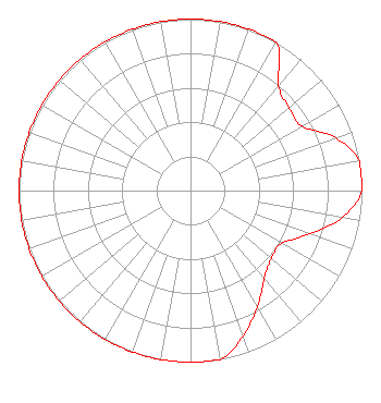 | ||||||||||||||||||
| Azimuth | Ratio | Azimuth | Ratio | Azimuth | Ratio | Azimuth | Ratio | ||||||||||||
| 0 | 1.000 | 10 | 1.000 | 20 | 1.000 | 30 | 1.000 | ||||||||||||
| 40 | 0.800 | 50 | 0.750 | 60 | 0.750 | 70 | 0.900 | ||||||||||||
| 80 | 1.000 | 90 | 1.000 | 100 | 0.900 | 110 | 0.740 | ||||||||||||
| 120 | 0.615 | 130 | 0.615 | 140 | 0.670 | 150 | 0.780 | ||||||||||||
| 160 | 0.900 | 170 | 1.000 | 180 | 1.000 | 190 | 1.000 | ||||||||||||
| 200 | 1.000 | 210 | 1.000 | 220 | 1.000 | 230 | 1.000 | ||||||||||||
| 240 | 1.000 | 250 | 1.000 | 260 | 1.000 | 270 | 1.000 | ||||||||||||
| 280 | 1.000 | 290 | 1.000 | 300 | 1.000 | 310 | 1.000 | ||||||||||||
| 320 | 1.000 | 330 | 1.000 | 340 | 1.000 | 350 | 1.000 | ||||||||||||
Structure Registration Number 1017996 Structure Type: GTOWER Registered To: HOLSTON VALLEY BROADCASTING CORPORATION Structure Address: 1631 Bays Mountain Park Road Kingsport, TN County Name: Sullivan County ASR Issued: 03/14/2024 Date Built: 03/12/2024 Site Elevation: 694.9 m (2280 ft.) Structure Height: 152.4 m (500 ft.) Height Overall: 154.2 m (506 ft.) Overall Height AMSL: 849.1 m (2786 ft.) FAA Determination: 01/29/2024 FAA Study #: 2023-ASO-31407-OE FAA Circular #: 70/7460-1M Paint & Light FAA Chapters: 4, 6, 15 PRIOR STUDY 2012-ASO-11552-OE 36-31-36.8 N 82-35-12.7 W (NAD 83) 36-31-36.4 N 82-35-13.2 W (Converted to NAD 27) |
222 Commerce Street Kingsport, TN 37660 Phone: 423-246-9578 | Date: 11/25/2003 Application Certifier MURRAY COMMUNICATIONS 1028 Woodstone Drive Kingsport, TN 37663 Applicant DAVID T. MURRAY 1028 Woodstone Drive Kingsport, TN 37663-2930 GENERAL PARTNER JOHN F. GARZIGLIA, ESQ. Womble Carlyle Sandridge & Rice, Pllc | |||||||||||||||||
| |||||||||||||||||||