
FCCInfo.com
A Service of Cavell, Mertz & Associates, Inc.
(855) FCC-INFO
|
|
K212AK from 05/17/2002 K212AK from 04/03/1986 |
|
|
||||||||||||||||
|
|
K212AK Channel: 212D 90.3 MHz Corvallis, Oregon Service: FX - A translator or application for a translator. Facility ID: 72002 Fac. Service: FX Programming Delivery Method: Unspecified Status: License Application Accepted: 10/11/2005 Application Granted: 12/20/2005 File Number: BLFT-20051011ABY License Expires: 00/00/0000 Prefix Type: This is a license for a translator Application Type: License To Cover FCC Website Links: LMS Facility Details This Application CDBS Application Other K212AK Applications Other K212AK Applications in CDBS Including Superseded Applications Mailing Address Correspondence for K212AK Correspondence related to application BLFT-20051011ABY Service Contour - Open Street Map or USGS Map (60 dBu) Service Contour - KML / Google Earth (60 dBu) Class: D, A Noncommercial educational operating with no more than 10W Site Location: 44-38-45.4 N 123-16-15.4 W (NAD 83) Site Location: 44-38-46.0 N 123-16-11.0 W (Converted to NAD 27) Effective Radiated Power: 0 kW Horiz. ; 0.01 kW Vert. Transmitter Output Power: 0.004 kW Antenna Center HAAT: 0 m Horiz.; 333.5 m Vert. Antenna Center AMSL: 0 m Horiz.; 478 m Vert. Antenna Center HAG: 0 m Horiz.; 21 m Vert. Site Elevation: 457 m. (1499 ft.) Height Overall*: 65 m (213 ft.) (* As Filed In This Application, may differ from ASR Data, Below.) Directional Antenna Antenna Make/Model: None Antenna ID: 70656 Polarization:
| ||||||||||||||||||
| Antenna Data for Antenna Id: 70656 K212AK FX File: BLFT-20051011ABY None - Service: FX Pattern and Field Values Include a 200° Clockwise Rotation | 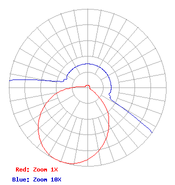 | ||||||||||||||||||
| Azimuth | Ratio | Azimuth | Ratio | Azimuth | Ratio | Azimuth | Ratio | ||||||||||||
| 0 | 0.030 | 10 | 0.030 | 20 | 0.030 | 30 | 0.030 | ||||||||||||
| 40 | 0.030 | 50 | 0.030 | 60 | 0.030 | 70 | 0.030 | ||||||||||||
| 80 | 0.030 | 90 | 0.030 | 100 | 0.030 | 110 | 0.030 | ||||||||||||
| 120 | 0.050 | 130 | 0.190 | 140 | 0.390 | 150 | 0.544 | ||||||||||||
| 160 | 0.690 | 170 | 0.817 | 180 | 0.916 | 190 | 0.980 | ||||||||||||
| 200 | 1.000 | 210 | 0.980 | 220 | 0.916 | 230 | 0.817 | ||||||||||||
| 240 | 0.690 | 250 | 0.544 | 260 | 0.390 | 270 | 0.190 | ||||||||||||
| 280 | 0.050 | 290 | 0.030 | 300 | 0.030 | 310 | 0.030 | ||||||||||||
| 320 | 0.030 | 330 | 0.030 | 340 | 0.030 | 350 | 0.030 | ||||||||||||
Structure Registration Number 1227466 Structure Type: TOWER Registered To: American Towers LLC Structure Address: Vineyard Mtn #40999--pnw Corvallis, OR County Name: Benton County ASR Issued: 01/15/2013 Date Built: 02/25/1999 Site Elevation: 456.9 m (1499 ft.) Structure Height: 61.6 m (202 ft.) Height Overall: 64.6 m (212 ft.) Overall Height AMSL: 521.5 m (1711 ft.) FAA Determination: 07/05/2001 FAA Study #: 01-ANM-1483-OE FAA Circular #: 70/7460-1K Paint & Light FAA Chapters: 4, 8, 12 Removed expiration date from determination. Scenario 1./jjs/case#635066 44-38-45.0 N 123-16-14.9 W (NAD 83) 44-38-45.6 N 123-16-10.5 W (Converted to NAD 27) |
4002 N. 3300 E. Twin Falls, ID 83303 Phone: 208-734-6633 Not-for-Profit | Date: 10/11/2005 Application Certifier CALVARY CHAPEL OF TWIN FALLS, INC. 4002 N. 3300 E. Twin Falls, ID 83301 Applicant LOIS MILLS 4002 N. 3300 E. Twin Falls, ID 83301 APPLICATIONS TECHNICIAN CARY S. TEPPER, ESQ Booth, Freret, Imlay & Tepper, P.c. 7900 Wisconsin Ave Bethesda, MD 20814 | |||||||||||||||||