
FCCInfo.com
A Service of Cavell, Mertz & Associates, Inc.
(855) FCC-INFO
|
|
|
|
|
||||||||||||||||
|
|
W235AK Channel: 235D 94.9 MHz Lexington, Kentucky Service: FX - A translator or application for a translator. Facility ID: 150275 Fac. Service: FX Programming Delivery Method: Unspecified Status: License Application Accepted: 08/15/2011 Application Granted: 08/31/2011 File Number: BLFT-20110815ABB License Expires: 00/00/0000 Prefix Type: This is a license for a translator Application Type: License To Cover FCC Website Links: LMS Facility Details This Application CDBS Application Other W235AK Applications Other W235AK Applications in CDBS Including Superseded Applications Mailing Address Correspondence for W235AK Correspondence related to application BLFT-20110815ABB Service Contour - Open Street Map or USGS Map (60 dBu) Service Contour - KML / Google Earth (60 dBu) Class: D, A Noncommercial educational operating with no more than 10W Site Location: 38-03-56.3 N 84-29-12.8 W (NAD 83) Site Location: 38-03-56.0 N 84-29-13.0 W (Converted to NAD 27) Effective Radiated Power: 0.25 kW Transmitter Output Power: 0.459 kW Antenna Center HAAT: 142.7 m Horiz.; 0 m Vert. Antenna Center AMSL: 427 m (1401 ft.) Antenna Center HAG: 137 m (449 ft.) Site Elevation: 290 m. (951 ft.) Height Overall*: 204 m (669 ft.) (* As Filed In This Application, may differ from ASR Data, Below.) Directional Antenna Antenna Make/Model: None Antenna ID: 102930 Polarization:
| ||||||||||||||||||
| Antenna Data for Antenna Id: 102930 W235AK FX File: BLFT-20110815ABB None - Service: FX | 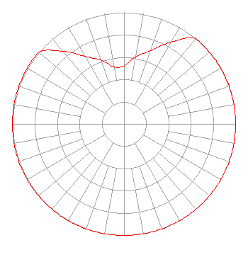 | ||||||||||||||||||
| Azimuth | Ratio | Azimuth | Ratio | Azimuth | Ratio | Azimuth | Ratio | ||||||||||||
| 0 | 0.520 | 10 | 0.610 | 20 | 0.700 | 30 | 0.850 | ||||||||||||
| 40 | 1.000 | 50 | 1.000 | 60 | 1.000 | 70 | 1.000 | ||||||||||||
| 80 | 1.000 | 90 | 1.000 | 100 | 1.000 | 110 | 1.000 | ||||||||||||
| 120 | 1.000 | 130 | 1.000 | 140 | 1.000 | 150 | 1.000 | ||||||||||||
| 160 | 1.000 | 170 | 1.000 | 180 | 1.000 | 190 | 1.000 | ||||||||||||
| 200 | 1.000 | 210 | 1.000 | 220 | 1.000 | 230 | 1.000 | ||||||||||||
| 240 | 1.000 | 250 | 1.000 | 260 | 1.000 | 270 | 1.000 | ||||||||||||
| 280 | 1.000 | 290 | 1.000 | 300 | 1.000 | 310 | 1.000 | ||||||||||||
| 320 | 0.850 | 330 | 0.700 | 340 | 0.610 | 350 | 0.520 | ||||||||||||
Structure Registration Number 1043247 Structure Type: TOWER Registered To: Scripps Broadcasting Holdings LLC Structure Address: 1065 Russell Cave Road Lexington, KY County Name: Fayette County ASR Issued: 05/02/2019 Date Built: 01/01/1959 Site Elevation: 289.6 m (950 ft.) Structure Height: 183.1 m (601 ft.) Height Overall: 204.3 m (670 ft.) Overall Height AMSL: 493.9 m (1620 ft.) Paint & Light FAA Chapters: 1, 3, 5, 14, 21 38-03-56.0 N 84-29-13.0 W (NAD 83) 38-03-55.7 N 84-29-13.2 W (Converted to NAD 27) |
680 Barclay Boulevard Lincolnshire, IL 60069 Phone: 877-291-0123 | Date: 08/15/2011 Application Certifier THY KINGDOM COME NETWORK, INC. 195 Moore Drive Lexington, KY 40503 Applicant CHARLES M. ANDERSON 1519 Euclid Avenue Bowling Green, KY 42103 BROADCAST CONSULTANT JOHN F. GARZIGLIA, ESQ. Womble Carlyle Sandridge & Rice, Pllc 1401 Eye Street, N.w. Seventh Floor Washington, DC 20005 | |||||||||||||||||